Greetings Card > Europe > Poland > Maps
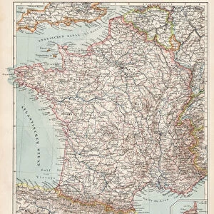
Greetings Card : Map of Moscow (Russia), the Kingdom of Sweden, the Baltic Provinces and Part of Poland
, the Kingdom of Sweden, the Baltic Provinces and Part of Poland")


, the Kingdom of Sweden, the Baltic Provinces and Part of Poland")


![]()
Cards from Fine Art Finder
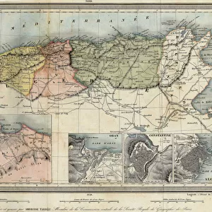
Map of Moscow (Russia), the Kingdom of Sweden, the Baltic Provinces and Part of Poland
LRI4711219 Map of Moscow (Russia), the Kingdom of Sweden, the Baltic Provinces and Part of Poland (etching, 1717) by Nolin, Jean-Baptiste (c.1657-1708); Private Collection; (add.info.: Map of Moscow (Russia), the Kingdom of Sweden, the Baltic Provinces and Part of Poland - Engraving from the atlas The Theatre of the World, 1717, by Jean Baptiste Nolin (1686-1762) - Map of Russia, Sweden and Baltics - From " Le Theatre du Monde" 1717 by Jean-Baptiste Nolin); Luisa Ricciarini; French, out of copyright
Media ID 22278596
© Luisa Ricciarini / Bridgeman Images
Atlas Book Baltic Countries Nordic Countries Poland Polish Suede Geographical Map
Greetings Card (A5)
Add a touch of history and culture to your greetings with our exquisite selection from the Media Storehouse range. Featuring an intricately detailed etching of a map by Luisa Ricciarini, this card showcases the historic territories of Moscow (Russia), the Kingdom of Sweden, the Baltic Provinces, and Part of Poland, as depicted in the 1717 map by Nolin. Share the rich heritage of these regions with your loved ones through this beautifully designed, fine art greeting card.
Create your own greetings card. Size when folded is A5 (14.5x21cm or 5.7x8.3 inches)
Greetings Cards suitable for Birthdays, Weddings, Anniversaries, Graduations, Thank You and much more
Estimated Image Size (if not cropped) is 21cm x 14.5cm (8.3" x 5.7")
Estimated Product Size is 21cm x 29cm (8.3" x 11.4")
These are individually made so all sizes are approximate
Artwork printed orientated as per the preview above, with landscape (horizontal) orientation to match the source image.
FEATURES IN THESE COLLECTIONS
> Fine Art Finder
> Artists
> Jean-Baptiste Nolin
> Fine Art Finder
> Artists
> Unknown Artist
> Europe
> Poland
> Related Images
> Europe
> Russia
> Related Images
EDITORS COMMENTS
This print showcases a historical map titled "Map of Moscow (Russia), the Kingdom of Sweden, the Baltic Provinces and Part of Poland". Created in 1717 by Jean-Baptiste Nolin, this etching is part of his renowned atlas, The Theatre of the World. The intricate details depicted on this map transport us back to a time when Russia, Sweden, and the Baltic countries were at the forefront of European politics and power struggles. With its precise geographical markings, one can trace the borders that defined these nations during the 18th century. Nolin's expertise in cartography shines through as he meticulously captures not only political boundaries but also key cities and landmarks across this vast region. The viewer is invited to explore Moscow's grandeur, witness Sweden's influence over neighboring territories, and appreciate Poland's significant presence within this dynamic landscape. As we delve into history through this beautifully preserved engraving from Luisa Ricciarini's private collection, we are reminded of how maps have always been essential tools for understanding our world. They provide valuable insights into past civilizations' ambitions and territorial conquests while offering glimpses into their cultural identities. Whether you are an avid historian or simply fascinated by geography, this remarkable artwork invites you to embark on a visual journey through centuries-old landscapes that continue to shape our present-day narratives.
MADE IN THE UK
Safe Shipping with 30 Day Money Back Guarantee
FREE PERSONALISATION*
We are proud to offer a range of customisation features including Personalised Captions, Color Filters and Picture Zoom Tools
SECURE PAYMENTS
We happily accept a wide range of payment options so you can pay for the things you need in the way that is most convenient for you
* Options may vary by product and licensing agreement. Zoomed Pictures can be adjusted in the Basket.