Greetings Card > Fine Art Finder > Artists > Robert Morden
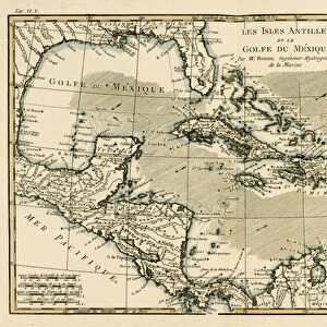
Greetings Card : A New Map of the English Plantations in America, 1673 (coloured engraving)
")

")

Please select a smaller print size for this image
![]()
Cards from Fine Art Finder
A New Map of the English Plantations in America, 1673 (coloured engraving)
XYC281179 A New Map of the English Plantations in America, 1673 (coloured engraving) by Morden, Robert (fl.1682-1703); 43.3x53.2 cm; Yale Center for British Art, Paul Mellon Collection, USA; English, out of copyright
Media ID 12794653
© www.bridgemanart.com
Atlantic Ocean British Colonies Caribbean Cartouche Central America Colonies Continent Deep South Gulf Of Mexico Islands Layout Panama Plantation West Indies English Colony
Greetings Card Large (A4)
Add a touch of historical charm to your greetings with Media Storehouse's range of cards featuring the intricately detailed engraving, "A New Map of the English Plantations in America, 1673." This beautiful coloured image, taken from the Yale Center for British Art's Paul Mellon Collection, showcases Robert Morden's (fl.1682-1703) impressive cartographic skills. The vibrant colours and meticulous detailing bring the English colonies in America to life, making this card an exquisite and thoughtful choice for any occasion.
Create your own large greetings card. Size when folded is A4 (21x30cm or 8.3x11.7 inches)
Greetings Cards suitable for Birthdays, Weddings, Anniversaries, Graduations, Thank You and much more
Estimated Image Size (if not cropped) is 29.7cm x 21cm (11.7" x 8.3")
Estimated Product Size is 29.7cm x 42cm (11.7" x 16.5")
These are individually made so all sizes are approximate
Artwork printed orientated as per the preview above, with landscape (horizontal) orientation to match the source image.
EDITORS COMMENTS
This print showcases "A New Map of the English Plantations in America, 1673" a beautifully colored engraving by Robert Morden. Measuring at 43.3x53.2 cm, this historic map is housed at the Yale Center for British Art as part of the esteemed Paul Mellon Collection in the USA. The map presents an intricate depiction of North America and its surrounding regions during the colonial era. It highlights various English colonies, stretching from the Gulf of Mexico to the Caribbean and across the Atlantic Ocean. The layout encompasses numerous islands within these territories, including those found in Central America and Panama. Meticulously crafted with attention to detail, this cartographic masterpiece provides invaluable insight into British colonization efforts during that time period. The presence of plantation symbols signifies their significance within these colonies. Notably, a striking cartouche adorns one corner of the map, adding an artistic touch to its overall composition. This particular print captures both historical accuracy and aesthetic appeal. As we gaze upon this remarkable piece from www. bridgemanart. com's collection, we are transported back to a pivotal moment in history when European powers were vying for dominance over new lands and resources. It serves as a reminder of our complex past while also celebrating human curiosity and exploration that has shaped our world today.
MADE IN THE UK
Safe Shipping with 30 Day Money Back Guarantee
FREE PERSONALISATION*
We are proud to offer a range of customisation features including Personalised Captions, Color Filters and Picture Zoom Tools
SECURE PAYMENTS
We happily accept a wide range of payment options so you can pay for the things you need in the way that is most convenient for you
* Options may vary by product and licensing agreement. Zoomed Pictures can be adjusted in the Basket.