Greetings Card > Arts > Artists > B > Charles Marie Rigobert Bonne
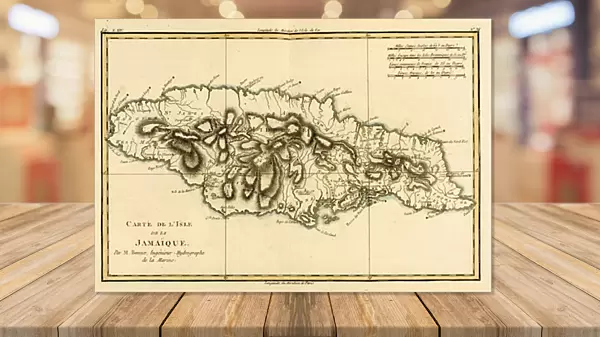
Greetings Card : The Island of Jamaica, from Atlas de Toutes les Parties Connues du Globe Terrestre


![]()
Cards from Fine Art Finder
The Island of Jamaica, from Atlas de Toutes les Parties Connues du Globe Terrestre
KW206601 The Island of Jamaica, from Atlas de Toutes les Parties Connues du Globe Terrestre by Guillaume Raynal (1713-96) published 1780 (coloured engraving) by Bonne, Charles Marie Rigobert (1727-95); Private Collection; Ken Welsh; French, out of copyright
Media ID 12755733
© www.bridgemanimages.com
Antilles Caribbean Jamaican West Indian West Indies
Greetings Card (A5)
Transport yourself to the vibrant shores of Jamaica with our exquisite range of greeting cards. Featuring a captivating image from Atlas de Toutes les Parties Connues du Globe Terrestre by Guillaume Raynal, published in 1780, these cards bring the rich history and natural beauty of the island right to your doorstep. Perfect for expressing warmth, friendship, or simply sending a touch of tropical paradise, our Jamaica greeting cards are a thoughtful and unique way to connect with loved ones.
Create your own greetings card. Size when folded is A5 (14.5x21cm or 5.7x8.3 inches)
Greetings Cards suitable for Birthdays, Weddings, Anniversaries, Graduations, Thank You and much more
Estimated Image Size (if not cropped) is 21cm x 14.5cm (8.3" x 5.7")
Estimated Product Size is 21cm x 29cm (8.3" x 11.4")
These are individually made so all sizes are approximate
Artwork printed orientated as per the preview above, with landscape (horizontal) orientation to match the source image.
FEATURES IN THESE COLLECTIONS
> Fine Art Finder
> Artists
> Charles Marie Rigobert Bonne
> Fine Art Finder
> Maps (celestial & Terrestrial)
> Arts
> Artists
> B
> Charles Marie Rigobert Bonne
> Maps and Charts
> Related Images
> North America
> Jamaica
> Maps
> North America
> Jamaica
> Related Images
EDITORS COMMENTS
This print showcases "The Island of Jamaica" from the renowned Atlas de Toutes les Parties Connues du Globe Terrestre by Guillaume Raynal. Published in 1780, this beautifully colored engraving is a true masterpiece that takes us back to the Caribbean paradise during the West Indian era. The image transports us to an enchanting world where lush greenery meets crystal-clear turquoise waters. The map depicts every intricate detail of Jamaica, capturing its unique shape and geographical features with precision. From its stunning coastline to its majestic mountains, this print encapsulates the island's natural beauty. As we delve into this historical piece, it becomes evident that it holds immense cultural significance. It provides a glimpse into Jamaica's rich history and heritage as part of the Antilles and West Indies regions. This artwork serves as a testament to Charles Marie Rigobert Bonne's exceptional cartographic skills and his dedication to documenting the known world. Displayed in a private collection, this exquisite print offers viewers an opportunity to appreciate both artistry and geography simultaneously. Its vibrant colors breathe life into every corner of the island, evoking a sense of wanderlust within us all. Through this photographical treasure trove from Fine Art Finder via Bridgeman Images, we are reminded of Jamaica's allure - not just as a tourist destination but also as an integral part of our global history.
MADE IN THE UK
Safe Shipping with 30 Day Money Back Guarantee
FREE PERSONALISATION*
We are proud to offer a range of customisation features including Personalised Captions, Color Filters and Picture Zoom Tools
SECURE PAYMENTS
We happily accept a wide range of payment options so you can pay for the things you need in the way that is most convenient for you
* Options may vary by product and licensing agreement. Zoomed Pictures can be adjusted in the Basket.