Glass Place Mat > Europe > United Kingdom > England > Sussex > Chidham
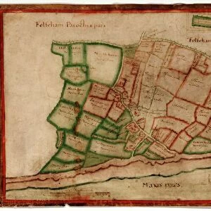
Glass Place Mat : Chidham Tithe Map, 1846


![]()
Home Decor from West Sussex County Council
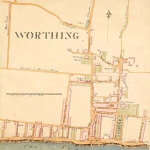
Chidham Tithe Map, 1846
By E. Fuller, Chichester. 13.3 in. to 1m. Original map size 54in. × 37in.
Tithe Award Map Collection
West Sussex Record Office Ref No: TD/W30
West Sussex County Council Record Office contains a fascinating history of the county of West Sussex, England
Media ID 7915672
© West Sussex County Council - All Rights Reserved
Glass Place Mat (Set of 4)
Set of 4 Glass Place Mats. Stylish and elegant polished safety glass, toughened and heat resistant (275x225mm, 7mm thick). Matching Coasters also available.
Set of 4 Glass Place Mats. Elegant polished safety glass and heat resistant. Matching Coasters may also be available
Estimated Image Size (if not cropped) is 17.7cm x 25.4cm (7" x 10")
Estimated Product Size is 22.5cm x 27.5cm (8.9" x 10.8")
These are individually made so all sizes are approximate
FEATURES IN THESE COLLECTIONS
> Europe
> United Kingdom
> England
> Sussex
> Chichester
> Europe
> United Kingdom
> England
> Sussex
> Chidham
> Europe
> United Kingdom
> England
> Sussex
> Related Images
> Europe
> United Kingdom
> England
> West Sussex
> Chichester
> Europe
> United Kingdom
> England
> West Sussex
> Related Images
> Maps and Charts
> Early Maps
> Maps and Charts
> Related Images
> West Sussex County Council
> West Sussex Record Office
> Tithe Award Maps, 1808-1859
EDITORS COMMENTS
This print showcases the Chidham Tithe Map of 1846, a remarkable piece of historical mapping created by E. Fuller from Chichester. Measuring an impressive 13.3 inches to 1 meter, this print is a faithful reproduction of the original map which spanned an astounding size of 54 inches by 37 inches. Part of the esteemed Tithe Award Map Collection housed at the West Sussex Record Office, this artifact offers a fascinating glimpse into the past and provides valuable insights into land ownership and usage during the mid-19th century in Chidham. The intricate details captured in this print unveil a wealth of information about rural life and agricultural practices prevalent at that time. From delineated boundaries to meticulously labeled fields, farms, and homesteads, every element on this map tells its own story. Preserved with utmost care by West Sussex County Council, this photograph serves as a testament to their commitment towards safeguarding our heritage for future generations. It stands as a reminder of our collective history and allows us to appreciate how landscapes have evolved over time. While it's important not to mention commercial use for legal reasons surrounding copyright restrictions or licensing agreements associated with these materials – we can instead focus on celebrating the invaluable educational value they hold for researchers, historians, genealogists, or anyone passionate about exploring our local history.
MADE IN THE UK
Safe Shipping with 30 Day Money Back Guarantee
FREE PERSONALISATION*
We are proud to offer a range of customisation features including Personalised Captions, Color Filters and Picture Zoom Tools
SECURE PAYMENTS
We happily accept a wide range of payment options so you can pay for the things you need in the way that is most convenient for you
* Options may vary by product and licensing agreement. Zoomed Pictures can be adjusted in the Basket.

![Royal Engineers bomb disposal team at work, [Mar 1941]](/sq/479/royal-engineers-bomb-disposal-team-work-8359434.jpg.webp)


![Chichester St. Peter the Great [Subdeanery] tithe map, 1846-1847](/sq/479/chichester-st-peter-great-subdeanery-tithe-10701869.jpg.webp)