Home > Europe > United Kingdom > England > Sussex > Middleton-on-Sea
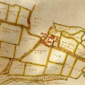
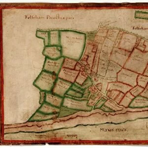
Map of the Manor of Middleton, 1606

![]()
Wall Art and Photo Gifts from West Sussex County Council
Map of the Manor of Middleton, 1606
Map of the Manor of Middleton, surveyed by John Norden, showing land in the south-west of the Parish of Middleton, including buildings such as St Nicholas Church that are now under the sea
Additional Manuscript Collection
West Sussex Record Office Ref No: Add Mss 2030
West Sussex County Council Record Office contains a fascinating history of the county of West Sussex, England
Media ID 5977911
Bognor Regis Church Coast Local History Sussex Coastal Erosion Felpham
FEATURES IN THESE COLLECTIONS
> Arts
> Artists
> N
> John Norden
> Europe
> United Kingdom
> England
> Sussex
> Bognor Regis
> Europe
> United Kingdom
> England
> Sussex
> Felpham
> Europe
> United Kingdom
> England
> Sussex
> Middleton-on-Sea
> Europe
> United Kingdom
> England
> West Sussex
> Bognor Regis
> Maps and Charts
> Early Maps
> Religious Art
> Religious Architecture
> Churches and Cathedrals
> West Sussex County Council
> Urban
> West Sussex County Council
> West Sussex Record Office
> Additional Manuscript
EDITORS COMMENTS
This print showcases a remarkable piece of history - the "Map of the Manor of Middleton, 1606". Surveyed by John Norden, this map provides a glimpse into the past, revealing land in the south-west of the Parish of Middleton. However, what makes this map truly intriguing is that it depicts buildings such as St Nicholas Church that are now submerged beneath the sea. The image captures an era long gone, with its rich historical significance evident in every detail. The Latin inscriptions and intricate design highlight the craftsmanship involved in creating this estate map. Its vibrant colors add depth to our understanding of how these lands were once divided and utilized. Located along the Sussex coast near Bognor Regis, Middleton-on-Sea has witnessed coastal erosion over centuries. This photograph serves as a poignant reminder of how nature's relentless forces can reshape our landscapes and erase tangible links to our past. Preserved within West Sussex Record Office's Additional Manuscript Collection under Ref No: Add Mss 2030, this valuable artifact offers invaluable insights into local history. It allows us to explore Felpham's heritage and understand its evolution through time. While commercial use is not permitted for this image, its educational value cannot be understated. Through careful examination and study, we can appreciate both the beauty captured within this colored map and gain a deeper appreciation for our ancestors' lives on these now-submerged lands off England's southern coast.
MADE IN THE UK
Safe Shipping with 30 Day Money Back Guarantee
FREE PERSONALISATION*
We are proud to offer a range of customisation features including Personalised Captions, Color Filters and Picture Zoom Tools
SECURE PAYMENTS
We happily accept a wide range of payment options so you can pay for the things you need in the way that is most convenient for you
* Options may vary by product and licensing agreement. Zoomed Pictures can be adjusted in the Basket.