Glass Place Mat > Arts > Pop art > Satire > Humorous artworks
Glass Place Mat : ANTI-RUSSIAN MAP, 1904. A Humorous Diplomatic Atlas of Europe and Asia


![]()
Home Decor from Granger
ANTI-RUSSIAN MAP, 1904. A Humorous Diplomatic Atlas of Europe and Asia
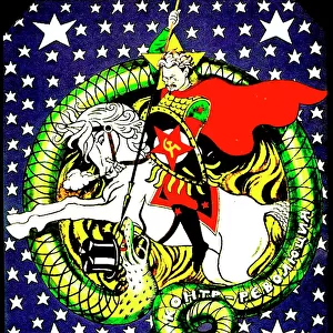
ANTI-RUSSIAN MAP, 1904. A Humorous Diplomatic Atlas of Europe and Asia. Japanese propaganda handbill of 1904 portraying Russia as a grasping octopus, strangling every European and Asian nation within reach of its tentacles, inspired by Frederick W. Roses satirical map of 1877
Granger holds millions of images spanning more than 25,000 years of world history, from before the Stone Age to the dawn of the Space Age
Media ID 6620101
1904 Allegory Anti Colonialism Calligraphy Cartouche Colonialism Diplomacy Empire Handbill Japan Japanese Meiji Octopus Personification Politics Propaganda Russia Russian Satire Tentacle Anti Russian
Glass Place Mat (Set of 4)
Set of 4 Glass Place Mats. Stylish and elegant polished safety glass, toughened and heat resistant (275x225mm, 7mm thick). Matching Coasters also available.
Set of 4 Glass Place Mats. Elegant polished safety glass and heat resistant. Matching Coasters may also be available
Estimated Image Size (if not cropped) is 25.4cm x 15.7cm (10" x 6.2")
Estimated Product Size is 27.5cm x 22.5cm (10.8" x 8.9")
These are individually made so all sizes are approximate
FEATURES IN THESE COLLECTIONS
> Arts
> Pop art
> Satire
> Humorous artworks
> Arts
> Pop art
> Satire
> Satirical artwork
> Asia
> Japan
> Related Images
> Asia
> Related Images
> Europe
> Russia
> Related Images
> Maps and Charts
> Early Maps
> Granger Art on Demand
> Maps
ANTI-RUSSIAN MAP, 1904 - Unveiling the Tentacles of Imperialism
EDITORS COMMENTS
. This print takes us back to a pivotal moment in history - the year 1904. A Humorous Diplomatic Atlas of Europe and Asia, this Japanese propaganda handbill serves as a powerful visual representation of geopolitical tensions during that time. Inspired by Frederick W. Roses' satirical map from 1877, it portrays Russia as an insatiable octopus with its tentacles wrapped around every European and Asian nation within reach. The intricate details showcased in this allegorical masterpiece are truly remarkable. Each tentacle represents Russia's expanding influence through colonialism, while simultaneously strangling the sovereignty of other nations. The clever use of personification breathes life into this political satire, revealing Japan's perspective on Russian aggression. From the elegant calligraphy to the meticulously designed cartouche, every element in this artwork speaks volumes about Meiji-era politics and propaganda. It sheds light on Japan's growing empire and their anti-colonialist stance against Russian dominance. As we delve into history through this thought-provoking image, let us reflect upon how art can be employed as a tool for diplomacy and social commentary. This ANTI-RUSSIAN MAP stands as a testament to the power of visuals in shaping public opinion and highlighting global conflicts at critical junctures in time.
MADE IN THE UK
Safe Shipping with 30 Day Money Back Guarantee
FREE PERSONALISATION*
We are proud to offer a range of customisation features including Personalised Captions, Color Filters and Picture Zoom Tools
SECURE PAYMENTS
We happily accept a wide range of payment options so you can pay for the things you need in the way that is most convenient for you
* Options may vary by product and licensing agreement. Zoomed Pictures can be adjusted in the Basket.