Glass Place Mat > North America > United States of America > Massachusetts > Boston
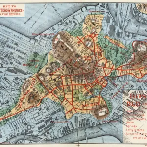
Glass Place Mat : MAP: BOSTON, 1883. Map of Boston, Massachusetts, and environs, published by Cupples, Upham & Co. 1883


![]()
Home Decor from Granger
MAP: BOSTON, 1883. Map of Boston, Massachusetts, and environs, published by Cupples, Upham & Co. 1883
Granger holds millions of images spanning more than 25,000 years of world history, from before the Stone Age to the dawn of the Space Age
Media ID 7548725
1883 Boston Boston Harbor Chromo Lithograph Dorchester Harbor Roxbury Suburb Town Upham
Glass Place Mat (Set of 4)
Set of 4 Glass Place Mats. Stylish and elegant polished safety glass, toughened and heat resistant (275x225mm, 7mm thick). Matching Coasters also available.
Set of 4 Glass Place Mats. Elegant polished safety glass and heat resistant. Matching Coasters may also be available
Estimated Image Size (if not cropped) is 25.4cm x 16.5cm (10" x 6.5")
Estimated Product Size is 27.5cm x 22.5cm (10.8" x 8.9")
These are individually made so all sizes are approximate
FEATURES IN THESE COLLECTIONS
> Animals
> Mammals
> Muridae
> Plains Mouse
> Maps and Charts
> Related Images
> North America
> Jamaica
> Maps
> North America
> Jamaica
> Related Images
> North America
> United States of America
> Massachusetts
> Boston
> Granger Art on Demand
> Boston Maps and Views
EDITORS COMMENTS
This print takes us back in time to the bustling city of Boston in 1883. The meticulously detailed map, published by Cupples, Upham & Co. , offers a fascinating glimpse into the layout and environs of this vibrant American town during that era. The chromo lithograph showcases the intricate engravings and text that bring life to every street, river, and suburb captured on the map. From the iconic Boston Harbor to the meandering river cutting through its heart, this historical document provides a comprehensive view of the city's geography. As we examine this piece closely, we are transported to neighborhoods like Dorchester, Roxbury, Jamaica Plain – each with their own unique charm and character. The map not only serves as a navigational tool but also as a window into Boston's past; it allows us to imagine what life was like for its residents over a century ago. The Granger Collection has beautifully preserved this artifact from history through their expert printing techniques. This print is more than just an image; it represents an invaluable connection between our present-day fascination with nostalgia and our desire to understand how cities evolve over time. Whether you're a history enthusiast or simply appreciate artful depictions of urban landscapes, this stunning print will undoubtedly captivate your imagination as you explore every intricacy within its borders.
MADE IN THE UK
Safe Shipping with 30 Day Money Back Guarantee
FREE PERSONALISATION*
We are proud to offer a range of customisation features including Personalised Captions, Color Filters and Picture Zoom Tools
SECURE PAYMENTS
We happily accept a wide range of payment options so you can pay for the things you need in the way that is most convenient for you
* Options may vary by product and licensing agreement. Zoomed Pictures can be adjusted in the Basket.