
Boston Harbor Collection
"Boston Harbor: Where History and Beauty Converge" As the sun begins to rise, casting a golden glow over the city


All Professionally Made to Order for Quick Shipping
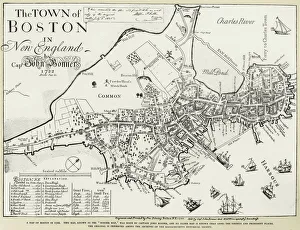
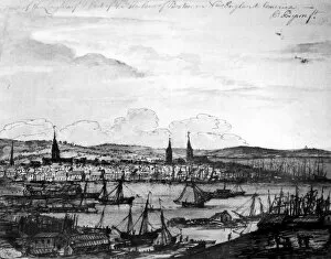
"Boston Harbor: Where History and Beauty Converge" As the sun begins to rise, casting a golden glow over the city, the skyline of Boston's Financial District emerges across the tranquil waters of Boston Harbor. The dawn paints a breathtaking picture that epitomizes the charm and allure of this iconic harbor. Looking back in time, we glimpse into Boston's rich history through ancient maps. A facsimile of John Bonner's 1722 map reveals how the city's topography has evolved over centuries. Cupples, Upham & Co. 's 1883 map showcases an expanding metropolis on the cusp of modernization. Standing at Rowes Wharf by Boston Harbor, one can't help but feel connected to both past and present. This historic site serves as a gateway between old-world charm and contemporary vibrancy, and is here that you can witness Bunker Hill Monument proudly standing tall alongside USS Constitution – reminders of America's revolutionary spirit. The inner harbor unfolds before our eyes like a masterpiece painted with hues of blue and silver at dawn. The reflection of towering skyscrapers dances on gentle waves, creating an ethereal ambiance unique to this enchanting place. Boston Harbor is not just any harbor; it is where stories are woven into its very fabric. From its role in shaping American history to being a bustling hub for trade and commerce today – it encapsulates resilience and progress. So come explore this captivating destination where land meets sea – from picturesque views along its shores to vibrant neighborhoods waiting to be discovered. Immerse yourself in all that Boston Harbor has to offer because within these waters lies a world full of wonderment awaiting your arrival.