Glass Place Mat > Aerial Photography > Related Images
Glass Place Mat : Sioux Falls South Dakota US City Street Map


![]()
Home Decor from Fine Art Storehouse
Sioux Falls South Dakota US City Street Map
Vector Illustration of a City Street Map of Sioux Falls, South Dakota, USA. Scale 1:60, 000.
All source data is in the public domain.
U.S. Geological Survey, US Topo
Used Layers:
USGS The National Map: National Hydrography Dataset (NHD)
USGS The National Map: National Transportation Dataset (NTD)
Unleash your creativity and transform your space into a visual masterpiece!
Frank Ramspott
Media ID 15215798
© Frank Ramspott, all rights reserved
Aerial View City Map Computer Graphic Directly Above Downtown District Gray Road Map South Dakota Text Digitally Generated Image Green Color Sioux Falls White Color
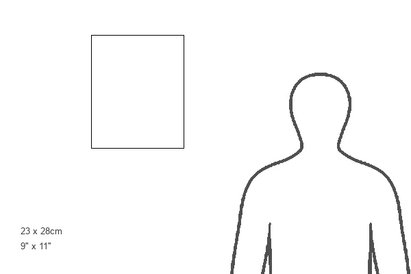
Glass Place Mat (Set of 4)
Set of 4 Glass Place Mats. Stylish and elegant polished safety glass, toughened and heat resistant (275x225mm, 7mm thick). Matching Coasters also available.
Set of 4 Glass Place Mats. Elegant polished safety glass and heat resistant. Matching Coasters may also be available
Estimated Image Size (if not cropped) is 22.5cm x 25.4cm (8.9" x 10")
Estimated Product Size is 22.5cm x 27.5cm (8.9" x 10.8")
These are individually made so all sizes are approximate
FEATURES IN THESE COLLECTIONS
> Fine Art Storehouse
> Map
> Street Maps
> Fine Art Storehouse
> Map
> USA Maps
> Aerial Photography
> Related Images
> Animals
> Insects
> Hemiptera
> Green Scale
> Arts
> Contemporary art
> Digital artwork
> Street art
> Arts
> Landscape paintings
> Waterfall and river artworks
> River artworks
> Arts
> Portraits
> Pop art gallery
> Street art portraits
> Arts
> Street art graffiti
> Digital art
> Digital paintings
> Arts
> Street art graffiti
> Digital art
> Vector illustrations
> Maps and Charts
> Geological Map
> Maps and Charts
> Related Images
> North America
> United States of America
> Lakes
> Related Images
EDITORS COMMENTS
This print showcases a meticulously detailed city street map of Sioux Falls, South Dakota, USA. With a scale of 1:60,000, every intricate detail is brought to life in this vector illustration. The source data used for this artwork is all in the public domain and comes from the U. S. Geological Survey's National Map, including the National Hydrography Dataset (NHD) and National Transportation Dataset (NTD). The image captures the essence of Sioux Falls' downtown district with its bustling streets and vibrant energy. A beautiful lake and river add to the charm of this cityscape, creating a harmonious blend between urban development and natural beauty. The digitally generated image features an aerial view directly above Sioux Falls, allowing viewers to appreciate its layout from a unique perspective. The color palette includes shades of gray, blue, white, and green that enhance the visual appeal while maintaining clarity. Designed by Frank Ramspott exclusively for Fine Art Storehouse, this stunning piece of cartography art is perfect for those who appreciate both design aesthetics and geographical accuracy. It serves as a testament to the rich history and modernity coexisting within Sioux Falls' boundaries
MADE IN THE UK
Safe Shipping with 30 Day Money Back Guarantee
FREE PERSONALISATION*
We are proud to offer a range of customisation features including Personalised Captions, Color Filters and Picture Zoom Tools
SECURE PAYMENTS
We happily accept a wide range of payment options so you can pay for the things you need in the way that is most convenient for you
* Options may vary by product and licensing agreement. Zoomed Pictures can be adjusted in the Basket.