Glass Place Mat > Arts > Landscape paintings > Landscape art > Landscape paintings
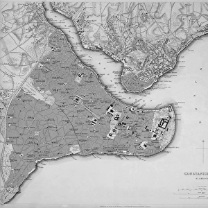
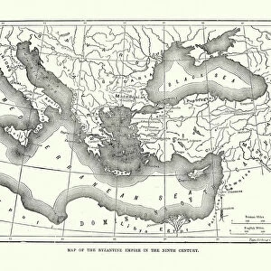
Glass Place Mat : City map of Constantinople (Istanbul, Turkey), lithograph, published in 1897
, lithograph, published in 1897")
, lithograph, published in 1897")


![]()
Home Decor from Fine Art Storehouse
City map of Constantinople (Istanbul, Turkey), lithograph, published in 1897
City map of Constantinople (Istanbul, Turkey). Lithograph, published in 1897
Unleash your creativity and transform your space into a visual masterpiece!
Media ID 15372263
© This content is subject to copyright
Bosphorus City Map Constantinople Downtown District Istanbul Ottoman Empire Turkey Turkish Culture Multi Colored
Glass Place Mat (Set of 4)
Set of 4 Glass Place Mats. Stylish and elegant polished safety glass, toughened and heat resistant (275x225mm, 7mm thick). Matching Coasters also available.
Set of 4 Glass Place Mats. Elegant polished safety glass and heat resistant. Matching Coasters may also be available
Estimated Image Size (if not cropped) is 25.4cm x 16.2cm (10" x 6.4")
Estimated Product Size is 27.5cm x 22.5cm (10.8" x 8.9")
These are individually made so all sizes are approximate
FEATURES IN THESE COLLECTIONS
> Fine Art Storehouse
> Map
> Historical Maps
> Arts
> Landscape paintings
> Landscape art
> Landscape paintings
> Asia
> Related Images
> Asia
> Turkey
> Related Images
> Europe
> Related Images
> Maps and Charts
> Early Maps
> Maps and Charts
> Related Images
EDITORS COMMENTS
This lithograph print from 1897 showcases the city map of Constantinople, now known as Istanbul, Turkey. A true testament to the rich history and cultural significance of this ancient metropolis, the print takes us on a journey back in time to the vibrant streets and bustling downtown district of the Ottoman Empire. The intricate details captured in this artwork highlight not only the geographical layout but also offer glimpses into Turkish culture during that era. The propontis, sea of Marmara, and Bosphorus are beautifully depicted with shades of blue reflecting their proximity to water bodies. The coastline is adorned with bays and harbors while red accents mark important landmarks throughout the city. Spanning across both Europe and Asia, Constantinople's strategic location has made it a melting pot of diverse influences over centuries. This print serves as a visual reminder of its unique position bridging two continents. With its horizontal landscape format and multi-colored engravings, this antique lithograph transports us back to an era long gone by. It evokes nostalgia for an old world charm that still lingers amidst modernity. As we gaze upon this historical treasure, we can't help but marvel at how much Istanbul has transformed since then while cherishing its timeless beauty that continues to captivate visitors from around the globe.
MADE IN THE UK
Safe Shipping with 30 Day Money Back Guarantee
FREE PERSONALISATION*
We are proud to offer a range of customisation features including Personalised Captions, Color Filters and Picture Zoom Tools
SECURE PAYMENTS
We happily accept a wide range of payment options so you can pay for the things you need in the way that is most convenient for you
* Options may vary by product and licensing agreement. Zoomed Pictures can be adjusted in the Basket.