Glass Place Mat > Maps and Charts > Turkey
Glass Place Mat : Map of Turkey, c.1900 (engraving)
")
")


![]()
Home Decor from Fine Art Finder
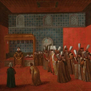
Map of Turkey, c.1900 (engraving)
532998 Map of Turkey, c.1900 (engraving); (add.info.: Map showing historical boundaries of the European portion of Turkey, circa 1902, from the 10th edition of Encyclopaedia Britannica.); Encyclopaedia Britannica/UIG
Media ID 38208744
© Encyclopaedia Britannica/UIG / Bridgeman Images
1902 19th Century Style Boundary Geographical Border Guidance Illustration Technique Meridian Navigational Equipment Old Fashioned Part Of Physical Geography The Past Turkish Culture Western Script Central Turkey Turk
Glass Place Mat (Set of 4)
Set of 4 Glass Place Mats. Stylish and elegant polished safety glass, toughened and heat resistant (275x225mm, 7mm thick). Matching Coasters also available.
Set of 4 Glass Place Mats. Elegant polished safety glass and heat resistant. Matching Coasters may also be available
Estimated Image Size (if not cropped) is 17.9cm x 25.4cm (7" x 10")
Estimated Product Size is 22.5cm x 27.5cm (8.9" x 10.8")
These are individually made so all sizes are approximate
FEATURES IN THESE COLLECTIONS
> Asia
> Turkey
> Related Images
> Maps and Charts
> Early Maps
> Maps and Charts
> Related Images
EDITORS COMMENTS
This engraving of a Map of Turkey from around 1900 offers a glimpse into the historical boundaries of the European portion of this culturally rich country. The intricate details and old-fashioned charm of this map, sourced from the 10th edition of Encyclopaedia Britannica, showcase the artistry and precision that went into cartography during that era.
The map not only highlights geographical features such as coastlines and boundaries but also serves as a window into the past, providing insight into Turkey's place in history. It is a testament to the importance of exploration and navigation in understanding our world.
As we study this piece, we are reminded of Turkey's unique position at the crossroads between Europe and Asia, blending elements from both continents to create its own distinct identity. The vertical orientation adds an interesting perspective to this historical artifact, inviting us to delve deeper into its significance.
Overall, this Map of Turkey is not just a visual representation but a gateway to learning about Turkish culture, history, and geography. It serves as a reminder of how maps have played a crucial role in shaping our understanding of different countries and regions throughout time.
MADE IN THE UK
Safe Shipping with 30 Day Money Back Guarantee
FREE PERSONALISATION*
We are proud to offer a range of customisation features including Personalised Captions, Color Filters and Picture Zoom Tools
SECURE PAYMENTS
We happily accept a wide range of payment options so you can pay for the things you need in the way that is most convenient for you
* Options may vary by product and licensing agreement. Zoomed Pictures can be adjusted in the Basket.