Glass Place Mat > Arts > Artists > G > Giovanni Xenodocus da Corfu
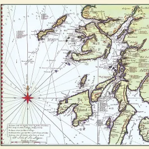
Glass Place Mat : The French Coast, England, Scotland and Ireland, from a nautical atlas, 1520 (ink on vellum)
")
")


![]()
Home Decor from Fine Art Finder
The French Coast, England, Scotland and Ireland, from a nautical atlas, 1520 (ink on vellum)
XOT330911 The French Coast, England, Scotland and Ireland, from a nautical atlas, 1520 (ink on vellum) (detail from 330910) by Giovanni Xenodocus da Corfu (fl. 16th Century); Museo Correr, Venice, Italy; Greek, out of copyright
Media ID 12852561
© www.bridgemanart.com
Chart Compass Mapping Portolan
Glass Place Mat (Set of 4)
Set of 4 Glass Place Mats. Stylish and elegant polished safety glass, toughened and heat resistant (275x225mm, 7mm thick). Matching Coasters also available.
Set of 4 Glass Place Mats. Elegant polished safety glass and heat resistant. Matching Coasters may also be available
Estimated Image Size (if not cropped) is 25.4cm x 19.8cm (10" x 7.8")
Estimated Product Size is 27.5cm x 22.5cm (10.8" x 8.9")
These are individually made so all sizes are approximate
FEATURES IN THESE COLLECTIONS
> Fine Art Finder
> Artists
> G
> Giovanni Xenodocus da Corfu Giovanni
> Fine Art Finder
> Artists
> Giovanni Xenodocus da Corfu
> Fine Art Finder
> Maps (celestial & Terrestrial)
> Arts
> Artists
> G
> Giovanni Xenodocus da Corfu
> Europe
> Greece
> Related Images
> Europe
> Italy
> Related Images
> Europe
> Italy
> Veneto
> Venice
> Europe
> Republic of Ireland
> Maps
EDITORS COMMENTS
This print takes us back in time to the 16th century, showcasing a detailed nautical atlas created by Giovanni Xenodocus da Corfu. The ink on vellum masterpiece depicts "The French Coast, England, Scotland and Ireland" offering a glimpse into the intricate world of cartography during this era. As we examine this exquisite detail from the larger artwork, our eyes are immediately drawn to the precision with which each coastline is depicted. The delicate lines and careful shading bring forth an air of authenticity that transports us to these distant lands. The artist's mastery is evident in his skillful use of portolan charts and compasses, which were essential tools for navigators at that time. Through their meticulous application, da Corfu has successfully captured not only the geographical features but also the spirit of exploration prevalent during this period. Displayed within Museo Correr in Venice, Italy, this piece serves as a testament to both artistic talent and historical significance. It reminds us of the invaluable role that maps played in shaping our understanding of the world centuries ago. Intriguingly timeless yet firmly rooted in its historical context, this photograph invites viewers to appreciate not only its aesthetic beauty but also its contribution to our collective knowledge about geography and navigation throughout history.
MADE IN THE UK
Safe Shipping with 30 Day Money Back Guarantee
FREE PERSONALISATION*
We are proud to offer a range of customisation features including Personalised Captions, Color Filters and Picture Zoom Tools
SECURE PAYMENTS
We happily accept a wide range of payment options so you can pay for the things you need in the way that is most convenient for you
* Options may vary by product and licensing agreement. Zoomed Pictures can be adjusted in the Basket.