Glass Place Mat > Arts > Artists > H > Franz Hogenberg
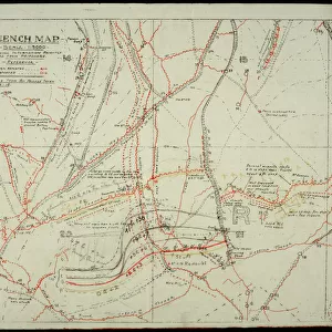
Glass Place Mat : Map of Lubeck (engraving, 16th century)
")
")


![]()
Home Decor From Fine Art Finder
Map of Lubeck (engraving, 16th century)
LRI4647056 Map of Lubeck (engraving, 16th century) by Hogenberg, Franz (1540-c.1590); Private Collection; (add.info.: Map of Lubeck - engraving from " Civitates Orbis Terrarum" by Georg Braun (1541-1622) and Frans Hogenberg (1535-1590).); Luisa Ricciarini; Netherlandish, out of copyright
Media ID 23016370
© Luisa Ricciarini / Bridgeman Images
Glass Place Mat (Set of 4)
Set of 4 Glass Place Mats. Stylish and elegant polished safety glass, toughened and heat resistant (275x225mm, 7mm thick). Matching Coasters also available.
Set of 4 Glass Place Mats. Elegant polished safety glass and heat resistant. Matching Coasters may also be available
Estimated Image Size (if not cropped) is 25.4cm x 9.7cm (10" x 3.8")
Estimated Product Size is 27.5cm x 22.5cm (10.8" x 8.9")
These are individually made so all sizes are approximate
FEATURES IN THESE COLLECTIONS
> Arts
> Artists
> H
> Franz Hogenberg
> Maps and Charts
> Related Images
EDITORS COMMENTS
This print showcases a remarkable piece of history - the "Map of Lubeck" engraved by Franz Hogenberg in the 16th century. The intricate details and precision of this engraving transport us back in time, offering a glimpse into the geographical landscape of Lubeck during that era. Taken from the renowned book "Civitates Orbis Terrarum" created by Georg Braun and Frans Hogenberg, this map is an invaluable treasure for cartography enthusiasts. It not only serves as a navigational tool but also provides insights into the cultural and architectural aspects of Lubeck at that time. The artist behind this stunning photograph, Luisa Ricciarini, has skillfully captured every minute detail with utmost clarity. From its delicate lines to its meticulous labeling, each element on this map comes alive through her lens. As we gaze upon this print, we are transported to a world where exploration was still in its infancy. We can almost imagine sailors plotting their voyages using maps like these or scholars studying them to gain knowledge about distant lands. Luisa Ricciarini's work reminds us of the importance of preserving historical artifacts like these engravings. They serve as windows into our past and allow us to appreciate how far we have come in terms of geographical understanding. In summary, this print offers more than just an image; it encapsulates centuries-old craftsmanship and invites us on a journey through time.
MADE IN THE UK
Safe Shipping with 30 Day Money Back Guarantee
FREE PERSONALISATION*
We are proud to offer a range of customisation features including Personalised Captions, Color Filters and Picture Zoom Tools
SECURE PAYMENTS
We happily accept a wide range of payment options so you can pay for the things you need in the way that is most convenient for you
* Options may vary by product and licensing agreement. Zoomed Pictures can be adjusted in the Basket.