Glass Place Mat > Europe > United Kingdom > Northern Ireland > Maps
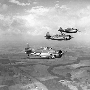
Glass Place Mat : Irish Free State And Northern Ireland. From Bacons Excelsior Atlas Of The World, Published Circa 1930


![]()
Home Decor from Design Pics
Irish Free State And Northern Ireland. From Bacons Excelsior Atlas Of The World, Published Circa 1930
Design Pics offers Distinctively Different Imagery representing over 1,500 contributors
Media ID 18191538
© Ken Welsh / Design Pics
Atlas Between Cartography First Free Irish North Northern Second State Wars World
Glass Place Mat (Set of 4)
Set of 4 Glass Place Mats. Stylish and elegant polished safety glass, toughened and heat resistant (275x225mm, 7mm thick). Matching Coasters also available.
Set of 4 Glass Place Mats. Elegant polished safety glass and heat resistant. Matching Coasters may also be available
Estimated Image Size (if not cropped) is 19.9cm x 25.4cm (7.8" x 10")
Estimated Product Size is 22.5cm x 27.5cm (8.9" x 10.8")
These are individually made so all sizes are approximate
FEATURES IN THESE COLLECTIONS
> Europe
> Republic of Ireland
> Maps
> Europe
> United Kingdom
> Northern Ireland
> Maps
> Europe
> United Kingdom
> Northern Ireland
> Posters
> Europe
> United Kingdom
> Northern Ireland
> Related Images
> Historic
> World War I and II
> World War I
> Historic
> World War I and II
> World War II
> Maps and Charts
> Related Images
> Maps and Charts
> World
EDITORS COMMENTS
This print showcases a historical map titled "Irish Free State And Northern Ireland" from the renowned Bacons Excelsior Atlas Of The World, published around 1930. A true gem of cartography, this vintage piece offers a fascinating glimpse into the intricate geopolitical landscape of Ireland during that era. The map is divided into two distinct regions: Irish Free State and Northern Ireland. It beautifully illustrates the complex political dynamics that emerged after the First World War and subsequent conflicts in the region. With meticulous detail, it outlines borders, cities, rivers, and other geographical features with precision. As we delve into this remarkable artifact by Ken Welsh, we are transported back to a time when Ireland was grappling with its newfound independence and partitioned identity. The Irish Free State represented one part of the island's struggle for self-governance while Northern Ireland remained under British rule. This photograph print not only captures an important moment in history but also serves as a reminder of how maps can tell powerful stories about our world's past. It invites us to reflect on the impact of war and colonialism on nations' boundaries and people's lives. Whether you are an avid collector or simply intrigued by history, this extraordinary image will undoubtedly spark curiosity and ignite conversations about Ireland's rich heritage.
MADE IN THE UK
Safe Shipping with 30 Day Money Back Guarantee
FREE PERSONALISATION*
We are proud to offer a range of customisation features including Personalised Captions, Color Filters and Picture Zoom Tools
SECURE PAYMENTS
We happily accept a wide range of payment options so you can pay for the things you need in the way that is most convenient for you
* Options may vary by product and licensing agreement. Zoomed Pictures can be adjusted in the Basket.