Glass Frame > Africa > Morocco > Maps
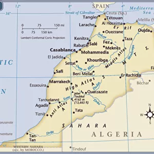
Glass Frame : Map of Spain and Morocco coast, by Diego Homen, from Portolan chart, 1557


![]()
Mounted Prints from Universal Images Group (UIG)
Map of Spain and Morocco coast, by Diego Homen, from Portolan chart, 1557
Cartography, 16th century. Map of Spain and Morocco coast, from a portolan chart by Diego Homen, 1557
Universal Images Group (UIG) manages distribution for many leading specialist agencies worldwide
Media ID 9501767
© DEA / A. DAGLI ORTI
16th Century Coastline Compass Rose Flag Morocco Peninsula Spain Tent Western Script Portolan Chart
7"x5" Glass Mount
Wall mounted or free-standing, these black edged glass frames feature a smooth chamfered edge and a stylish black border (on back face of the glass). Manufactured from 4mm thick glass, Glass Mounts are a durable, professional way of displaying and protecting your prints. Your 7x5 print is slotted into the back of the frame so can easily be changed if needed.
Tempered Glass Mounts are ideal for wall display, plus the smaller sizes can also be used free-standing via an integral stand
Estimated Image Size (if not cropped) is 12.7cm x 17.7cm (5" x 7")
Estimated Product Size is 16.2cm x 20.3cm (6.4" x 8")
These are individually made so all sizes are approximate
Artwork printed orientated as per the preview above, with portrait (vertical) orientation to match the source image.
FEATURES IN THESE COLLECTIONS
> Africa
> Morocco
> Related Images
> Maps and Charts
> Related Images
> Maps and Charts
> Spain
> Universal Images Group (UIG)
> Art
> Painting, Sculpture & Prints
> Cartography
EDITORS COMMENTS
This print showcases a remarkable piece of cartographic history, the "Map of Spain and Morocco coast" by Diego Homen. Created in 1557, this exquisite portolan chart provides an intriguing glimpse into the world of 16th-century navigation and exploration. The image depicts a vertical composition, capturing every intricate detail with precision. The map itself is adorned with Western script and features an elaborate compass rose, indicating the cardinal directions. Its vibrant colors bring to life the diverse landscapes along the Spanish and Moroccan coastlines. In this studio shot, we are transported back in time as we observe this ancient artifact. A tent-like structure serves as a backdrop for the map, evoking images of explorers embarking on daring journeys across uncharted territories. The building exterior adds to the historical ambiance while proudly displaying flags representing both Spain and Morocco. With no people present in this photograph, our focus is solely on appreciating this masterpiece from centuries past. This artful creation seamlessly combines craftsmanship and scientific accuracy to provide invaluable insights into early maritime navigation. As we gaze upon this print from Universal Images Group (UIG), we can't help but marvel at how far cartography has come since Diego Homen meticulously crafted his portolan chart over four centuries ago. It serves as a testament to human curiosity and determination to explore new frontiers—a timeless reminder that history continues to shape our understanding of the world today.
MADE IN THE UK
Safe Shipping with 30 Day Money Back Guarantee
FREE PERSONALISATION*
We are proud to offer a range of customisation features including Personalised Captions, Color Filters and Picture Zoom Tools
SECURE PAYMENTS
We happily accept a wide range of payment options so you can pay for the things you need in the way that is most convenient for you
* Options may vary by product and licensing agreement. Zoomed Pictures can be adjusted in the Basket.