Glass Frame > North America > United States of America > New York > New York > Maps
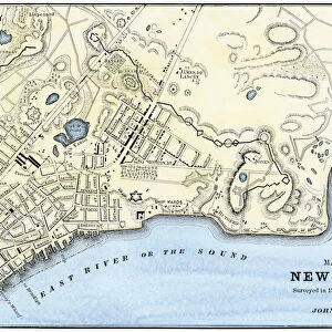
Glass Frame : New York City map, 1767


![]()
Mounted Prints from North Wind
New York City map, 1767
Map of New York City in 1767.
Hand-colored woodcut of an 18th-century illustration
North Wind Picture Archives brings history to life with stock images and hand-colored illustrations
Media ID 5882531
© North Wind Picture Archives
1700s 1760s 18th Century Chart Colonial Colonist Colony English English Colony Harbor Manhattan New York New York City 1767
7"x5" Glass Mount
Wall mounted or free-standing, these black edged glass frames feature a smooth chamfered edge and a stylish black border (on back face of the glass). Manufactured from 4mm thick glass, Glass Mounts are a durable, professional way of displaying and protecting your prints. Your 7x5 print is slotted into the back of the frame so can easily be changed if needed.
Tempered Glass Mounts are ideal for wall display, plus the smaller sizes can also be used free-standing via an integral stand
Estimated Image Size (if not cropped) is 17.7cm x 12.7cm (7" x 5")
Estimated Product Size is 20.3cm x 16.2cm (8" x 6.4")
These are individually made so all sizes are approximate
Artwork printed orientated as per the preview above, with landscape (horizontal) orientation to match the source image.
FEATURES IN THESE COLLECTIONS
> Historic
> Colonial America illustrations
> 18th century America
> Historic
> Colonial America illustrations
> Colonial America
> Historic
> Colonial America illustrations
> Historic
> Colonial history
> Colonial art and artists
> North America
> Related Images
> North America
> United States of America
> New York
> New York
> Manhattan
> Related Images
> North America
> United States of America
> New York
> New York
> Maps
> North America
> United States of America
> New York
> Related Images
> North Wind Picture Archives
> Maps
> North Wind Picture Archives
> New York City
EDITORS COMMENTS
This print showcases a remarkable piece of history - the New York City map from 1767. With its hand-colored woodcut and intricate details, this 18th-century illustration takes us back in time to the early days of America's most iconic city. The map depicts Manhattan as a colonial settlement, offering a glimpse into the past lives of colonists who called this place home. From the bustling harbor to the neatly laid out streets, every element tells a story of English colonization and the birth of an empire. As we study this vintage artwork, we can't help but marvel at how much has changed over centuries. The once small colony has transformed into one of the world's most vibrant metropolises - New York City. This historic illustration not only serves as a visual representation of our heritage but also reminds us that beneath today's modern skyscrapers lies a rich tapestry woven by generations before us. It is through such artifacts that we gain insight into our roots and appreciate how far we have come. Whether you are an art enthusiast or simply intrigued by history, this 1767 New York City map print is sure to captivate your imagination and transport you back to an era when dreams were being built upon these very streets.
MADE IN THE UK
Safe Shipping with 30 Day Money Back Guarantee
FREE PERSONALISATION*
We are proud to offer a range of customisation features including Personalised Captions, Color Filters and Picture Zoom Tools
SECURE PAYMENTS
We happily accept a wide range of payment options so you can pay for the things you need in the way that is most convenient for you
* Options may vary by product and licensing agreement. Zoomed Pictures can be adjusted in the Basket.