Glass Frame > Arts > Artists > S > George Smith
Glass Frame : Map of Smith Sound and Greenland, 1875


![]()
Mounted Prints from Mary Evans Picture Library
Map of Smith Sound and Greenland, 1875
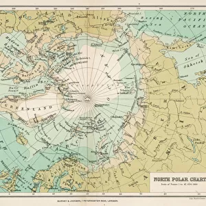
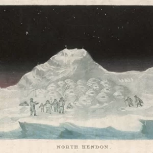
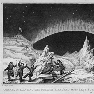
Engraving showing a map of Smith Sound and Greenland, as it was known in May 1875. Much of the map is erroneous or missing in detail, as the Arctic area had been little visited by Europeans up to that time. In the summer of 1875 the British Admiralty sent Captain George Nares with two ships, HMS Alert and HMS Discovery, to make an attempt to reach the North Pole via Smith Sound. The attempt was unsuccessful, but a new furthest North record was set, the coasts of Greenland and Ellesmere Island were further charted and much scientific data gathered
Mary Evans Picture Library makes available wonderful images created for people to enjoy over the centuries
Media ID 4385033
© Mary Evans Picture Library 2015 - https://copyrighthub.org/s0/hub1/creation/maryevans/MaryEvansPictureID/10217614
1875 Admiralty Arctic Area Attempt Charted Coasts Data Ellesmere Gathered Greenland Missing Nares Pole Reach Record Scientific Sound Unsuccessful Visited Europeans Smith
7"x5" Glass Mount
Wall mounted or free-standing, these black edged glass frames feature a smooth chamfered edge and a stylish black border (on back face of the glass). Manufactured from 4mm thick glass, Glass Mounts are a durable, professional way of displaying and protecting your prints. Your 7x5 print is slotted into the back of the frame so can easily be changed if needed.
Tempered Glass Mounts are ideal for wall display, plus the smaller sizes can also be used free-standing via an integral stand
Estimated Image Size (if not cropped) is 12.7cm x 17.7cm (5" x 7")
Estimated Product Size is 16.2cm x 20.3cm (6.4" x 8")
These are individually made so all sizes are approximate
Artwork printed orientated as per the preview above, with portrait (vertical) orientation to match the source image.
FEATURES IN THESE COLLECTIONS
> Arts
> Artists
> S
> George Smith
> Arts
> Artists
> S
> Mary Smith
> Europe
> Related Images
> Maps and Charts
> Early Maps
> Maps and Charts
> Related Images
> North America
> Greenland
> Maps
> North America
> Greenland
> Related Images
> Popular Themes
> North Island
EDITORS COMMENTS
This historical engraving from 1875 shows a map of Smith Sound and Greenland, capturing the limited knowledge Europeans had of the Arctic region at that time. The British Admiralty's attempt to reach the North Pole via Smith Sound with Captain George Nares leading the expedition aboard HMS Alert and HMS Discovery may have been unsuccessful in achieving their ultimate goal, but it did result in setting a new furthest North record.
The map itself is filled with errors and lacks detail due to the lack of European exploration in the area up to that point. However, this mission was not without its successes - further charting of the coasts of Greenland and Ellesmere Island took place, along with valuable scientific data being gathered.
This print serves as an important reminder of the challenges faced by early explorers venturing into uncharted territories, highlighting both their determination and resilience in pushing boundaries. It also stands as a testament to human curiosity and our relentless pursuit of knowledge about our world.
MADE IN THE UK
Safe Shipping with 30 Day Money Back Guarantee
FREE PERSONALISATION*
We are proud to offer a range of customisation features including Personalised Captions, Color Filters and Picture Zoom Tools
SECURE PAYMENTS
We happily accept a wide range of payment options so you can pay for the things you need in the way that is most convenient for you
* Options may vary by product and licensing agreement. Zoomed Pictures can be adjusted in the Basket.