Glass Frame > Maps and Charts > Related Images
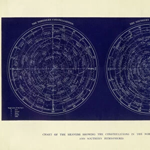
Glass Frame : Constellation map. On the left side, the northern


![]()
Mounted Prints from Mary Evans Picture Library
Constellation map. On the left side, the northern
" Constellation map. On the left side, the northern constellations and on the right side, the southern constellations. From the atlas " Tr鳯 r des cartes g鯧 raphiques des principaux Estats de Luniv". Engraving."
Mary Evans Picture Library makes available wonderful images created for people to enjoy over the centuries
Media ID 8278421
© Mary Evans Picture Library 2015 - https://copyrighthub.org/s0/hub1/creation/maryevans/MaryEvansPictureID/10683504
Astrological Astrology Atlas Constellation Constellations Engravings Southern Zodiac Zodiacal Cartes Firmament Planisphere Principaux
7"x5" Glass Mount
Wall mounted or free-standing, these black edged glass frames feature a smooth chamfered edge and a stylish black border (on back face of the glass). Manufactured from 4mm thick glass, Glass Mounts are a durable, professional way of displaying and protecting your prints. Your 7x5 print is slotted into the back of the frame so can easily be changed if needed.
Tempered Glass Mounts are ideal for wall display, plus the smaller sizes can also be used free-standing via an integral stand
Estimated Image Size (if not cropped) is 17.7cm x 12.7cm (7" x 5")
Estimated Product Size is 20.3cm x 16.2cm (8" x 6.4")
These are individually made so all sizes are approximate
Artwork printed orientated as per the preview above, with landscape (horizontal) orientation to match the source image.
EDITORS COMMENTS
1. Title: A Celestial Journey: Exploring the Northern and Southern Constellations through an Engraved Map from the 18th Century This print showcases an exquisite representation of the northern and southern constellations as depicted in the 1737 atlas "Très Noble et Curieuse Carte Géographique des Principaux États de Luneville et de leurs Environs, et Planisphère des Etoiles Fixedes" by Jean-Baptiste Nolin. The map is a testament to the intriguing world of astronomy and astrology during the Age of Enlightenment. On the left side of the map, the northern constellations are meticulously illustrated, each one named and connected by imaginary lines, forming a complex web of celestial patterns. The constellations, such as Ursa Major, Orion, and Cassiopeia, are instantly recognizable, their mythological stories and symbolism preserved through the ages. The zodiac, the twelve constellations that mark the path of the Sun throughout the year, is also delineated, adding an astrological dimension to the map. Conversely, the southern hemisphere is represented on the right side, with its unique constellations, such as Crux, Centaurus, and Scorpius, displayed in equal detail. These constellations were less familiar to northern observers, making their inclusion in the map a significant contribution to the growing body of astronomical knowledge. The intricate engravings, adorned with intricate borders and elaborate cartouches, attest to the meticulous craftsmanship and the dedication of the mapmaker to accurately represent the night sky. The map serves as a reminder of the fascination and wonder that the stars have held for humanity throughout history, inspiring generations of astronomers, astrologers, and curious minds to explore the mysteries of the universe.
MADE IN THE UK
Safe Shipping with 30 Day Money Back Guarantee
FREE PERSONALISATION*
We are proud to offer a range of customisation features including Personalised Captions, Color Filters and Picture Zoom Tools
SECURE PAYMENTS
We happily accept a wide range of payment options so you can pay for the things you need in the way that is most convenient for you
* Options may vary by product and licensing agreement. Zoomed Pictures can be adjusted in the Basket.