Glass Frame > Europe > France > Paris > Maps
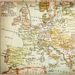
Glass Frame : Old Map of the World 1871


![]()
Mounted Prints from MapSeeker
Old Map of the World 1871
THE WORLD THAT WAS 1871 - End of Franco-Prussian War; Germany unified, and Empire formed; Third Republic in France; suppression of the Paris Commune. British Columbia joins Canada. Chicago fires. Stanley meets Livingstone near Lake Tanganyika (oDr Livingstone, I presume?o)
Welcome to the Mapseeker Image library and enter an historic gateway to one of the largest on-line collections of Historic Maps, Nostalgic Views, Vista's and Panorama's from a World gone by.
Media ID 20347533
© Collins Bartholomew - Mapseeker Publishing Ltd
Map Of The World Old Map Of The World The World World Map
7"x5" Glass Mount
Wall mounted or free-standing, these black edged glass frames feature a smooth chamfered edge and a stylish black border (on back face of the glass). Manufactured from 4mm thick glass, Glass Mounts are a durable, professional way of displaying and protecting your prints. Your 7x5 print is slotted into the back of the frame so can easily be changed if needed.
Tempered Glass Mounts are ideal for wall display, plus the smaller sizes can also be used free-standing via an integral stand
Estimated Image Size (if not cropped) is 17.7cm x 12.7cm (7" x 5")
Estimated Product Size is 20.3cm x 16.2cm (8" x 6.4")
These are individually made so all sizes are approximate
Artwork printed orientated as per the preview above, with landscape (horizontal) orientation to match the source image.
FEATURES IN THESE COLLECTIONS
> Europe
> France
> Lakes
> Related Images
> Europe
> France
> Paris
> Maps
> Europe
> Germany
> Lakes
> Related Images
> Historic
> World War I and II
> World War I
> Maps and Charts
> British Empire Maps
> Maps and Charts
> Related Images
> MapSeeker
> Maps Showing the World
> Maps of The World by Year PORTFOLIO
EDITORS COMMENTS
This print showcases an exquisite piece of history, the "Old Map of the World 1871". Stepping back in time, this map encapsulates a pivotal year marked by significant global events. As we explore its intricate details, we are transported to an era where the world was on the brink of transformation. The year 1871 witnessed several remarkable milestones that shaped nations and defined their destinies. The Franco-Prussian War had just concluded, leading to Germany's unification and the birth of a powerful empire. Meanwhile, France embraced a new era with the establishment of the Third Republic after enduring tumultuous times. Across continents, other notable occurrences left indelible marks on history. British Columbia joined Canada during this period, solidifying ties within North America. In Chicago, devastating fires ravaged through neighborhoods but failed to dampen spirits as resilience prevailed amidst adversity. Amidst these monumental events lies one extraordinary encounter: Stanley meets Livingstone near Lake Tanganyika - immortalized by those famous words: "Dr Livingstone, I presume?". This meeting between two renowned explorers symbolizes mankind's insatiable curiosity for discovery and adventure. As we admire this old map of the world from MapSeeker's collection, let us appreciate not only its aesthetic beauty but also its ability to transport us into a bygone era filled with triumphs and challenges alike. It serves as a testament to our collective journey through time while reminding us how far we have come since 1871.
MADE IN THE UK
Safe Shipping with 30 Day Money Back Guarantee
FREE PERSONALISATION*
We are proud to offer a range of customisation features including Personalised Captions, Color Filters and Picture Zoom Tools
SECURE PAYMENTS
We happily accept a wide range of payment options so you can pay for the things you need in the way that is most convenient for you
* Options may vary by product and licensing agreement. Zoomed Pictures can be adjusted in the Basket.