Glass Frame > Europe > United Kingdom > Scotland > Edinburgh > Edinburgh
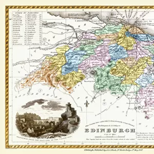
Glass Frame : Old Map of the County of Edinburgh from the Philips Handy Atlas of 1882


![]()
Mounted Prints from MapSeeker
Old Map of the County of Edinburgh from the Philips Handy Atlas of 1882
PHA010
Welcome to the Mapseeker Image library and enter an historic gateway to one of the largest on-line collections of Historic Maps, Nostalgic Views, Vista's and Panorama's from a World gone by.
Media ID 20348183
County Map County Map Of Scotland Edinburgh Historic Map Old County Map Old Scottish County Map Scottish County Map
7"x5" Glass Mount
Wall mounted or free-standing, these black edged glass frames feature a smooth chamfered edge and a stylish black border (on back face of the glass). Manufactured from 4mm thick glass, Glass Mounts are a durable, professional way of displaying and protecting your prints. Your 7x5 print is slotted into the back of the frame so can easily be changed if needed.
Tempered Glass Mounts are ideal for wall display, plus the smaller sizes can also be used free-standing via an integral stand
Estimated Image Size (if not cropped) is 17.7cm x 12.7cm (7" x 5")
Estimated Product Size is 20.3cm x 16.2cm (8" x 6.4")
These are individually made so all sizes are approximate
Artwork printed orientated as per the preview above, with landscape (horizontal) orientation to match the source image.
FEATURES IN THESE COLLECTIONS
> Europe
> United Kingdom
> Scotland
> Edinburgh
> Edinburgh
> Europe
> United Kingdom
> Scotland
> Edinburgh
> Europe
> United Kingdom
> Scotland
> Lothian
> Edinburgh
> Europe
> United Kingdom
> Scotland
> Maps
> Europe
> United Kingdom
> Scotland
> Posters
> Europe
> United Kingdom
> Scotland
> Related Images
> Maps and Charts
> Early Maps
> Maps and Charts
> Related Images
> MapSeeker
> Maps from the British Isles
> Scotland and Counties PORTFOLIO
EDITORS COMMENTS
This print showcases an exquisite piece of history, the "Old Map of the County of Edinburgh from the Philips Handy Atlas of 1882". Transporting us back in time, this Scottish county map offers a fascinating glimpse into the past. With intricate details and delicate craftsmanship, it serves as a testament to cartographic artistry. The carefully preserved lines and contours on this old county map provide valuable insights into the geography and boundaries of Edinburgh during a bygone era. As we explore its faded hues and weathered edges, we can almost hear echoes from centuries ago whispering tales of ancient settlements, bustling towns, and picturesque landscapes. This historic map is not merely an artifact; it is a portal to another world. It invites us to embark on a journey through time, unraveling stories woven within every inch. From majestic castles dotting the countryside to winding rivers meandering through lush valleys, each element tells a unique story about Scotland's capital city. Whether you are an avid historian or simply captivated by maps' allure, this old county map of Edinburgh will undoubtedly ignite your imagination. Its rich historical significance makes it perfect for educational purposes or as an eye-catching decorative piece that adds character and charm to any space. Embrace the nostalgia evoked by this remarkable photographic print—a tangible connection between our present-day lives and those who once walked these ancient lands.
MADE IN THE UK
Safe Shipping with 30 Day Money Back Guarantee
FREE PERSONALISATION*
We are proud to offer a range of customisation features including Personalised Captions, Color Filters and Picture Zoom Tools
SECURE PAYMENTS
We happily accept a wide range of payment options so you can pay for the things you need in the way that is most convenient for you
* Options may vary by product and licensing agreement. Zoomed Pictures can be adjusted in the Basket.