Glass Frame > Europe > United Kingdom > Scotland > Highlands > Cromarty
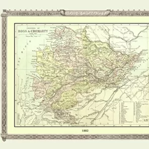
Glass Frame : Old Map of the Counties of Ross and Cromarty from the Philips Handy Atlas of 1882


![]()
Mounted Prints from MapSeeker
Old Map of the Counties of Ross and Cromarty from the Philips Handy Atlas of 1882
PHA026
Welcome to the Mapseeker Image library and enter an historic gateway to one of the largest on-line collections of Historic Maps, Nostalgic Views, Vista's and Panorama's from a World gone by.
Media ID 20348205
County Map County Map Of Scotland Historic Map Old County Map Old Scottish County Map Scottish County Map Cromarty Ross Ross And Cromarty Ross Shire
7"x5" Glass Mount
Wall mounted or free-standing, these black edged glass frames feature a smooth chamfered edge and a stylish black border (on back face of the glass). Manufactured from 4mm thick glass, Glass Mounts are a durable, professional way of displaying and protecting your prints. Your 7x5 print is slotted into the back of the frame so can easily be changed if needed.
Tempered Glass Mounts are ideal for wall display, plus the smaller sizes can also be used free-standing via an integral stand
Estimated Image Size (if not cropped) is 17.7cm x 12.7cm (7" x 5")
Estimated Product Size is 20.3cm x 16.2cm (8" x 6.4")
These are individually made so all sizes are approximate
Artwork printed orientated as per the preview above, with landscape (horizontal) orientation to match the source image.
FEATURES IN THESE COLLECTIONS
> Europe
> United Kingdom
> Scotland
> Cromartyshire
> Europe
> United Kingdom
> Scotland
> Highlands
> Cromarty
> Europe
> United Kingdom
> Scotland
> Maps
> Europe
> United Kingdom
> Scotland
> Posters
> Europe
> United Kingdom
> Scotland
> Related Images
> Europe
> United Kingdom
> Scotland
> Ross-shire
> Maps and Charts
> Early Maps
> Maps and Charts
> Related Images
> MapSeeker
> Maps from the British Isles
> Scotland and Counties PORTFOLIO
EDITORS COMMENTS
This print showcases an exquisite piece of history, the "Old Map of the Counties of Ross and Cromarty from the Philips Handy Atlas of 1882". Steeped in Scottish heritage, this vintage county map offers a fascinating glimpse into the past. With intricate details and delicate craftsmanship, this old Scottish county map takes us on a journey through time. It reveals the boundaries and topography of Ross and Cromarty, two counties nestled in Scotland's breathtaking landscapes. The historic map provides a window into the rich tapestry of these regions, offering insights into their cultural significance and historical importance. The careful preservation of this remarkable piece allows us to appreciate its beauty as well as unravel stories hidden within its lines. As we explore each contour and landmark depicted on this old county map, we can imagine ourselves traversing through quaint villages, ancient castles, and rolling hills that have witnessed centuries unfold. Whether you are an avid cartography enthusiast or simply captivated by Scotland's allure, this print is sure to ignite your imagination. Its historical value combined with its aesthetic appeal make it a cherished addition to any collection or display. Let yourself be transported back in time as you immerse yourself in the enchanting world captured within this stunning image – a testament to both artistry and history intertwined.
MADE IN THE UK
Safe Shipping with 30 Day Money Back Guarantee
FREE PERSONALISATION*
We are proud to offer a range of customisation features including Personalised Captions, Color Filters and Picture Zoom Tools
SECURE PAYMENTS
We happily accept a wide range of payment options so you can pay for the things you need in the way that is most convenient for you
* Options may vary by product and licensing agreement. Zoomed Pictures can be adjusted in the Basket.