Glass Frame > Animals > Mammals > Cricetidae > Meridionalis
Glass Frame : Map Circuli Saxoniae superioris pars meridionalis


![]()
Mounted Prints from Liszt Collection
Map Circuli Saxoniae superioris pars meridionalis
Map, Circuli Saxoniae superioris pars meridionalis in qua sunt ducatus Saxoniae comitatus Mansfeldiae et Voitlandiae landgraviat Thuringiae, marchionatus Misniae principatus Anhaltinus et episcopatus Hallensis, Frederick de Wit (1610-1698), Copperplate print
Liszt Collection of nineteenth-century engravings and images to browse and enjoy
Media ID 19585638
© Artokoloro
1610 1698 Copperplate Print Frederick De Wit
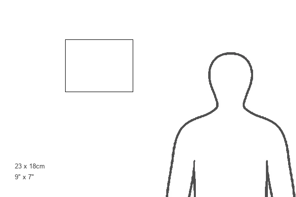
8"x6" Glass Mount
Wall mounted or free-standing, these black edged glass frames feature a smooth chamfered edge and a stylish black border (on back face of the glass). Manufactured from 4mm thick glass, Glass Mounts are a durable, professional way of displaying and protecting your prints. Your 8x6 print is slotted into the back of the frame so can easily be changed if needed.
Tempered Glass Mounts are ideal for wall display, plus the smaller sizes can also be used free-standing via an integral stand
Estimated Image Size (if not cropped) is 20.3cm x 15.2cm (8" x 6")
Estimated Product Size is 22.8cm x 17.7cm (9" x 7")
These are individually made so all sizes are approximate
Artwork printed orientated as per the preview above, with landscape (horizontal) orientation to match the source image.
FEATURES IN THESE COLLECTIONS
> Animals
> Mammals
> Cricetidae
> Meridionalis
> Animals
> Mammals
> Sciuridae
> Meridionalis
> Arts
> Artists
> W
> Frederick de Wit
> Maps and Charts
> Related Images
EDITORS COMMENTS
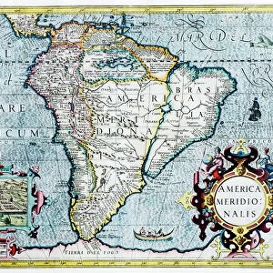
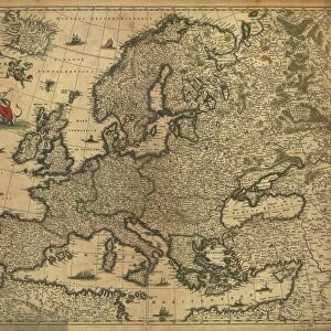
This print showcases the intricate details of "Map Circuli Saxoniae superioris pars meridionalis" by Frederick de Wit. The map depicts the southern part of Saxony, including various territories such as the Duchy of Saxony, Mansfeld County, Voitlandia, Thuringian Landgraviate, Margraviate of Meissen, Principality of Anhalt and Bishopric of Halle. With its copperplate print technique, this historical masterpiece exudes a sense of elegance and precision. Every line and contour is meticulously etched onto the surface to create a visually stunning representation of the region's geographical features. The Map Circuli Saxoniae superioris pars meridionalis not only serves as a navigational tool but also provides valuable insights into the political divisions during that era. It offers a glimpse into how power was distributed among different ruling entities within Saxony. Frederick de Wit's expertise in cartography is evident through his attention to detail and artistic flair. This print allows us to appreciate his craftsmanship and dedication to accurately capturing the essence of this significant region in Germany's history. Whether you are an avid collector or simply fascinated by historical maps, this print will undoubtedly be a remarkable addition to your collection. Its timeless beauty and rich historical context make it an invaluable piece for any enthusiast seeking to delve deeper into Europe's past.
MADE IN THE UK
Safe Shipping with 30 Day Money Back Guarantee
FREE PERSONALISATION*
We are proud to offer a range of customisation features including Personalised Captions, Color Filters and Picture Zoom Tools
SECURE PAYMENTS
We happily accept a wide range of payment options so you can pay for the things you need in the way that is most convenient for you
* Options may vary by product and licensing agreement. Zoomed Pictures can be adjusted in the Basket.