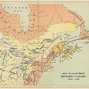
Glass Frame : COLONIAL AMERICA: MAP, c1770. The British Dominions in America. Map showing the British colonies and provinces in America, by Thomas Kitchin, c1770


![]()
Mounted Prints from Granger
COLONIAL AMERICA: MAP, c1770. The British Dominions in America. Map showing the British colonies and provinces in America, by Thomas Kitchin, c1770
Granger holds millions of images spanning more than 25,000 years of world history, from before the Stone Age to the dawn of the Space Age
Media ID 7561635
1770 Atlantic Ocean British Coast Colonial Colony East Great Lakes Lake Shore North America Province Dominion Kitchin
8"x6" Glass Mount
Wall mounted or free-standing, these black edged glass frames feature a smooth chamfered edge and a stylish black border (on back face of the glass). Manufactured from 4mm thick glass, Glass Mounts are a durable, professional way of displaying and protecting your prints. Your 8x6 print is slotted into the back of the frame so can easily be changed if needed.
Tempered Glass Mounts are ideal for wall display, plus the smaller sizes can also be used free-standing via an integral stand
Estimated Image Size (if not cropped) is 20.3cm x 15.2cm (8" x 6")
Estimated Product Size is 22.8cm x 17.7cm (9" x 7")
These are individually made so all sizes are approximate
Artwork printed orientated as per the preview above, with landscape (horizontal) orientation to match the source image.
EDITORS COMMENTS
COLONIAL AMERICA: MAP, c1770. The British Dominions in America. A fascinating glimpse into the past, this print showcases a meticulously detailed map of Colonial America by Thomas Kitchin, circa 1770. With its intricate engravings and precise cartographic representation, this historical artifact offers a visual narrative of the British colonies and provinces that once dominated the American continent. As we gaze upon this piece, we are transported back to an era when the East Coast of North America was teeming with colonial settlements and territories under British rule. From the Atlantic Ocean to the Great Lakes' shores, every province and colony is meticulously labeled, providing us with invaluable insights into how these regions were organized during that time. The craftsmanship displayed in this engraving is truly remarkable; it reflects Kitchin's dedication to accuracy and his commitment to capturing even the smallest details of geographical features. This map serves as both a testament to Kitchin's skill as a cartographer and an essential resource for historians seeking to understand Colonial America's political landscape. Whether you are an enthusiast of history or simply appreciate fine artistry, this print from Granger Art on Demand allows you to own a piece of our nation's rich heritage. Let it serve as a reminder of how far we have come since those early days while also honoring the legacy left behind by those who shaped our nation.
MADE IN THE UK
Safe Shipping with 30 Day Money Back Guarantee
FREE PERSONALISATION*
We are proud to offer a range of customisation features including Personalised Captions, Color Filters and Picture Zoom Tools
SECURE PAYMENTS
We happily accept a wide range of payment options so you can pay for the things you need in the way that is most convenient for you
* Options may vary by product and licensing agreement. Zoomed Pictures can be adjusted in the Basket.