Glass Frame > Africa > South Africa > Maps
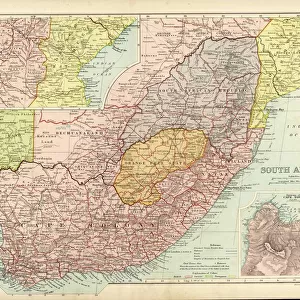
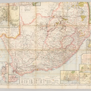
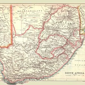
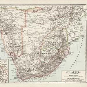
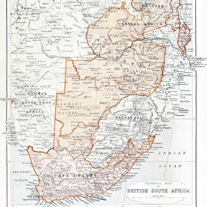
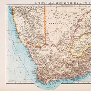
Glass Frame : Map of South Africa during the Second Boer War


![]()
Mounted Prints from Fine Art Storehouse
Map of South Africa during the Second Boer War
Vintage Map of South Africa during the Second Boer War
Unleash your creativity and transform your space into a visual masterpiece!
duncan1890
Media ID 13667087
© duncan1890
1890 1899 66698 78279 94456 Anglo Boer War Boer Free State Province Historical Geopolitical Location Historical War Event Image Created 1890 1899 Navigational Equipment South Africa Southern Africa Styles Image Created 19th Century Obsolete
7"x5" Glass Mount
Wall mounted or free-standing, these black edged glass frames feature a smooth chamfered edge and a stylish black border (on back face of the glass). Manufactured from 4mm thick glass, Glass Mounts are a durable, professional way of displaying and protecting your prints. Your 7x5 print is slotted into the back of the frame so can easily be changed if needed.
Tempered Glass Mounts are ideal for wall display, plus the smaller sizes can also be used free-standing via an integral stand
Estimated Image Size (if not cropped) is 12.7cm x 17.7cm (5" x 7")
Estimated Product Size is 16.2cm x 20.3cm (6.4" x 8")
These are individually made so all sizes are approximate
Artwork printed orientated as per the preview above, with portrait (vertical) orientation to match the source image.
FEATURES IN THESE COLLECTIONS
> Fine Art Storehouse
> Map
> Historical Maps
> Africa
> Related Images
> Africa
> South Africa
> Maps
> Africa
> South Africa
> Related Images
> Maps and Charts
> Early Maps
> Maps and Charts
> Related Images
EDITORS COMMENTS
This vintage print takes us back to the tumultuous era of the Second Boer War in South Africa. The intricately engraved image showcases a detailed map, meticulously illustrating the geopolitical landscape of this historical war event. Created in the 19th century, it exudes an air of authenticity and transports us to a bygone era. The vibrant colors bring life to this obsolete yet significant piece of history, allowing us to delve into the past and explore the territorial divisions during this time. The Free State Province and Transvaal Province are prominently featured, reminding us of their crucial roles in shaping Southern Africa's destiny. As we gaze at this vertical illustration, our eyes wander across its borders, tracing navigational routes that were once vital for strategic planning during conflicts. It serves as a reminder of how maps were not only tools but also witnesses to historical events. The image evokes thoughts about the brave Boer fighters who valiantly defended their land against British forces during the Anglo-Boer War. It sparks curiosity about their struggles and resilience amidst adversity. Duncan1890's artistic rendition beautifully captures all these elements, preserving an important chapter in South African history within one frame. This print is more than just an antique; it is a testament to human perseverance and serves as a visual gateway connecting us with our past.
MADE IN THE UK
Safe Shipping with 30 Day Money Back Guarantee
FREE PERSONALISATION*
We are proud to offer a range of customisation features including Personalised Captions, Color Filters and Picture Zoom Tools
SECURE PAYMENTS
We happily accept a wide range of payment options so you can pay for the things you need in the way that is most convenient for you
* Options may vary by product and licensing agreement. Zoomed Pictures can be adjusted in the Basket.