
Maps Glass Frame Collection
Discover the beauty and rich cultural heritage of Pakistan with our Maps of Pakistan, Asia collection of Glass Frames from Media Storehouse. These elegant frames showcase intricately detailed maps of Pakistan and the Asian region, handcrafted with precision and care. Each glass frame adds a touch of sophistication and worldly charm to any room, making it an ideal gift for the globetrotter, history buff, or geography enthusiast in your life. Explore the world, one frame at a time.
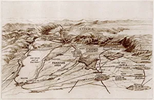
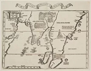
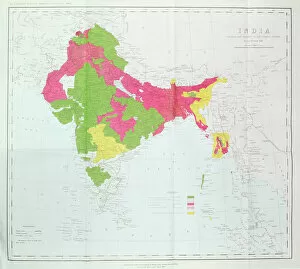
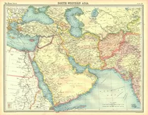
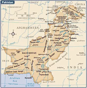
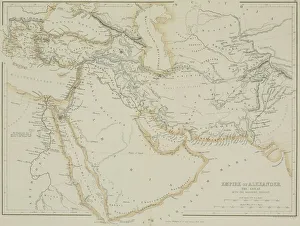
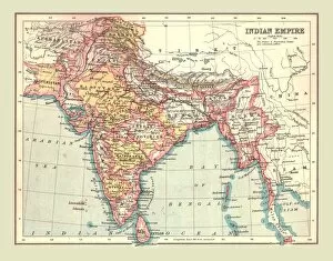
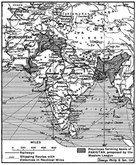
Pakistan is a country in South Asia, located at the crossroads of Central Asia and Western Asia, and is bordered by India to the east, Afghanistan to the west
Choose a picture from our Maps Glass Frame Collection for your Wall Art and Photo Gifts
55 Glass Frames


All Professionally Made to Order for Quick Shipping
-
Maps Glass Frame Collection
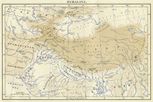
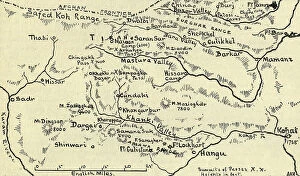
Pakistan is a country in South Asia, located at the crossroads of Central Asia and Western Asia, and is bordered by India to the east, Afghanistan to the west, Iran to the southwest and China in the far northeast. Maps of Pakistan are important tools for understanding its geography and political divisions. Maps show physical features such as rivers, mountains, deserts and forests; major cities; provincial boundaries; international borders; road networks; and other infrastructure. They also provide information about population density, economic activity, climate zones and other socio-economic indicators. Maps of Pakistan are essential for anyone travelling or doing business there as they provide an invaluable overview of this diverse country with its complex history.
+
Our beautiful Wall Art and Photo Gifts include Framed Prints, Photo Prints, Poster Prints, Canvas Prints, Jigsaw Puzzles, Metal Prints and so much more
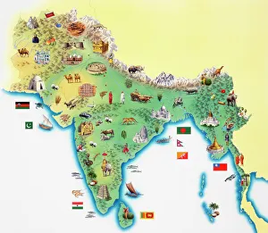
The Maps of Pakistan Asia collection from Media Storehouse is a stunning assortment of wall art and framed prints that showcase the beauty and diversity of Pakistan. Our collection features an array of maps, ranging from vintage to contemporary styles, which depict the country's geography, topography, and political boundaries. Each print in our collection is carefully crafted using high-quality materials to ensure longevity and durability. Customers can choose from a variety of sizes and framing options to suit their preferences. Whether you're looking for a unique piece of home decor or a thoughtful gift for someone who loves maps or has an interest in Pakistani culture, our collection offers something for everyone. With its striking colors and intricate details, each map is sure to be a conversation starter that will add character and charm to any room.
+
What are Maps of Pakistan Asia art prints?
Maps of Pakistan Asia art prints are high-quality reproductions of maps depicting the geographical features, cities, and regions of Pakistan. These prints are designed to showcase the beauty and intricacy of cartography as an art form while also providing a useful reference tool for those interested in exploring or studying the region. These maps can be used for educational purposes, such as in classrooms or libraries, or simply as decorative pieces in homes or offices. They come in a variety of sizes and styles to suit different preferences and needs. Whether you're looking to learn more about Pakistan's geography or simply appreciate the aesthetic value of these intricate maps, Maps of Pakistan Asia art prints offer a unique way to explore this fascinating country. With their detailed depictions of mountains, rivers, deserts, and other natural features, they provide a window into one of the world's most diverse and complex regions.
+
What Maps of Pakistan Asia art prints can I buy from Media Storehouse?
We offer a wide range of Maps of Pakistan Asia art prints that are perfect for anyone looking to add some cultural flair to their home or office. These maps showcase the intricate details and unique features of Pakistan, including its diverse geography, landmarks, and cities. Some popular options include vintage maps that capture the country's history and evolution over time, as well as contemporary designs that highlight its modernity and vibrancy. In addition to traditional paper prints, Media Storehouse also offers canvas prints that provide a more textured look and feel. These high-quality reproductions are created using state-of-the-art printing technology to ensure maximum clarity and color accuracy. Whether you're a collector of world maps or simply looking for an eye-catching piece of wall art, we have something for everyone. With so many different styles and sizes available, it's easy to find the perfect Maps of Pakistan Asia art print to suit your personal taste and decor style.
+
How do I buy Maps of Pakistan Asia art prints?
To buy Maps of Pakistan Asia art prints from Media Storehouse, you can browse through their vast collection of maps and select the one that suits your preferences. Once you have chosen the map, click on it to view its details and options for customization. You can choose from a range of sizes and framing options to suit your needs. To place an order, simply add the item to your cart and proceed to checkout. You will be prompted to enter your shipping address and payment information before completing the purchase. We offer high-quality art prints that are perfect for decorating homes or offices. Their maps are printed using state-of-the-art technology on premium quality paper, ensuring vibrant colors and sharp detail. Whether you're a collector or just looking for a unique piece of wall decor, buying Maps of Pakistan Asia art prints from Media Storehouse is easy and hassle-free.
+
How much do Maps of Pakistan Asia art prints cost?
We offer a wide range of Maps of Pakistan Asia art prints for purchase. The cost of these prints varies depending on the size and type of print that you choose. We have options ranging from small to large sizes, as well as different printing materials such as canvas or paper. Our Maps of Pakistan Asia art prints are high-quality reproductions that capture the beauty and detail of the original artwork. They make great additions to any home or office decor, adding a touch of culture and history to your space. We take pride in offering affordable prices for our customers without compromising on quality. Our goal is to provide you with beautiful art pieces that will last for years to come at a reasonable price point. If you're interested in purchasing one of our Maps of Pakistan Asia art prints, please visit our website or contact us directly for more information about pricing and availability.
+
How will my Maps of Pakistan Asia art prints be delivered to me?
We take great care in ensuring that your Maps of Pakistan Asia art prints are delivered to you safely and securely. We use high-quality packaging materials to protect your prints during transit, so they arrive at your doorstep in pristine condition. Once you place an order with us, our team will process it promptly and dispatch the prints from our warehouse. Depending on your location, we may use a variety of delivery services to get your order to you as quickly as possible. We understand how important it is for you to receive your artwork in a timely manner, which is why we work hard to ensure that all orders are shipped out within a reasonable timeframe. You can track the progress of your shipment using the tracking number provided by our delivery partners. We pride ourselves on delivering exceptional customer service and quality products. We hope that you enjoy your Maps of Pakistan Asia art prints.