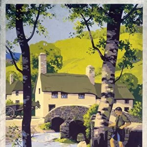
Glass Coaster > Europe > United Kingdom > England > Sussex > Albourne
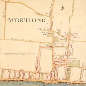
Glass Coaster : Albourne Tithe Map, 1838


![]()
Home Decor from West Sussex County Council
Albourne Tithe Map, 1838
Surveyed by Willm Bishop Harding, Land Surveyor & Draughtsman of Frome, Somerset, Septr 1838. Copied by Willm Duncum, March 1841.rn26.6 in. to 1 m. Original map sixe 80in. × 48in.
Tithe Award Map Collection
West Sussex Record Office Ref No: TD/E104
West Sussex County Council Record Office contains a fascinating history of the county of West Sussex, England
Media ID 7914363
© West Sussex County Council - All Rights Reserved
Glass Coaster
Individual Glass Coaster. Stylish and elegant polished safety glass, toughened and heat resistant (10x10cm, 7mm thick). Price shown is per individual coaster.
Individual Glass Coaster. Elegant polished safety toughened glass and heat resistant, matching Place Mats are also available
Estimated Image Size (if not cropped) is 4.6cm x 7.6cm (1.8" x 3")
Estimated Product Size is 10cm x 10cm (3.9" x 3.9")
These are individually made so all sizes are approximate
Artwork printed orientated as per the preview above, with portrait (vertical) orientation to match the source image.
FEATURES IN THESE COLLECTIONS
> Arts
> Artists
> H
> Harding Harding
> Europe
> France
> Canton
> Landes
> Europe
> United Kingdom
> England
> Somerset
> Aller
> Europe
> United Kingdom
> England
> Somerset
> Frome
> Europe
> United Kingdom
> England
> Somerset
> Related Images
> Europe
> United Kingdom
> England
> Sussex
> Albourne
> Europe
> United Kingdom
> England
> Sussex
> Related Images
> Europe
> United Kingdom
> England
> West Sussex
> Related Images
> Maps and Charts
> Early Maps
> Maps and Charts
> Related Images
> West Sussex County Council
> West Sussex Record Office
> Tithe Award Maps, 1808-1859
EDITORS COMMENTS
This print showcases the Albourne Tithe Map from 1838, a remarkable piece of historical mapping. The map was meticulously surveyed by Willm Bishop Harding, a skilled Land Surveyor & Draughtsman from Frome, Somerset in September 1838. It is worth noting that this particular copy was made by Willm Duncum in March 1841. Measuring an impressive size of 80 inches by 48 inches, this detailed map offers a fascinating glimpse into the past. With a scale ratio of 26.6 inches to one meter, it provides an accurate representation of the area it covers. Part of the esteemed Tithe Award Map Collection held at West Sussex Record Office, this valuable artifact sheds light on land ownership and usage during the early nineteenth century. Its significance lies not only in its historical value but also as a testament to the meticulous workmanship and dedication put forth by surveyors like Willm Bishop Harding. It is important to note that while this print captures the essence and beauty of this historic map, it should not be used for commercial purposes without proper authorization. Nevertheless, it serves as a reminder of our rich heritage and invites us to explore and appreciate our local history through cartography's lens.
MADE IN THE UK
Safe Shipping with 30 Day Money Back Guarantee
FREE PERSONALISATION*
We are proud to offer a range of customisation features including Personalised Captions, Color Filters and Picture Zoom Tools
SECURE PAYMENTS
We happily accept a wide range of payment options so you can pay for the things you need in the way that is most convenient for you
* Options may vary by product and licensing agreement. Zoomed Pictures can be adjusted in the Basket.