Glass Coaster > Maps and Charts > Abraham Ortelius
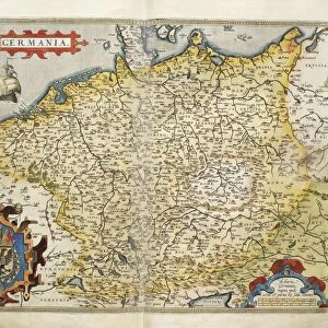
Glass Coaster : Orteliuss map of Germany, 1570


![]()
Home Decor from Science Photo Library
Orteliuss map of Germany, 1570
Orteliuss map of Germany. This map is from the 1570 first edition of Theatrum orbis terrarum ( Theatre of the World ). Drawn by the Flemish mapmaker Abraham Ortelius (1527-1598), and published by Gilles Coppens de Diest in Antwerp, this collection of 53 maps is considered to be the first true modern atlas
Science Photo Library features Science and Medical images including photos and illustrations
Media ID 6297325
© LIBRARY OF CONGRESS, GEOGRAPHY AND MAP DIVISION/SCIENCE PHOTO LIBRARY
1500s 1570 1570 Edition 16th Century Abraham Ortelius Age Of Discovery Antwerp Edition Cartographic Cartography Country Dutch Empire First Edition First Modern Atlas Flemish German Germany Gilles Coppens De Diest Holy Roman Empire Imperial Latin Latin Edition Nation Orteliuss Text Theatre Of The World Theatrum Orbis Terrarum Writing Germania Germanic
Glass Coaster
Individual Glass Coaster. Stylish and elegant polished safety glass, toughened and heat resistant (10x10cm, 7mm thick). Price shown is per individual coaster.
Individual Glass Coaster. Elegant polished safety toughened glass and heat resistant, matching Place Mats are also available
Estimated Image Size (if not cropped) is 7.6cm x 5.6cm (3" x 2.2")
Estimated Product Size is 10cm x 10cm (3.9" x 3.9")
These are individually made so all sizes are approximate
Artwork printed orientated as per the preview above, with landscape (horizontal) orientation to match the source image.
EDITORS COMMENTS
This print showcases Orteliuss map of Germany, a remarkable piece of cartographic art from the 16th century. Created by the renowned Flemish mapmaker Abraham Ortelius and published in Antwerp by Gilles Coppens de Diest, this particular edition is considered to be the first true modern atlas. The map itself is a testament to both historical significance and artistic brilliance. With intricate details and precise geographical accuracy, it offers a glimpse into the Germanic region during the age of discovery. The Latin text accompanying the illustration adds an air of authenticity and scholarly depth. As one explores this ancient depiction, they are transported back in time to witness the grandeur of the Holy Roman Empire. From imperial cities to sprawling landscapes, every corner of Germany is meticulously portrayed on this masterpiece. Orteliuss map not only serves as a valuable tool for understanding European history but also stands as a work of art in its own right. Its vibrant colors and meticulous craftsmanship make it an exquisite addition to any collection or display. In essence, this print captures more than just a map; it encapsulates centuries worth of knowledge, exploration, and human ingenuity. It reminds us that even in our modern world dominated by digital maps, there is still immense value in preserving these tangible pieces that connect us with our past.
MADE IN THE UK
Safe Shipping with 30 Day Money Back Guarantee
FREE PERSONALISATION*
We are proud to offer a range of customisation features including Personalised Captions, Color Filters and Picture Zoom Tools
SECURE PAYMENTS
We happily accept a wide range of payment options so you can pay for the things you need in the way that is most convenient for you
* Options may vary by product and licensing agreement. Zoomed Pictures can be adjusted in the Basket.