Glass Coaster > Africa > Morocco > Maps
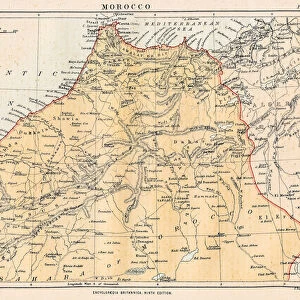
Glass Coaster : MAP / AFRICA / MOROCCO 1719


![]()
Home Decor from Mary Evans Picture Library
MAP / AFRICA / MOROCCO 1719
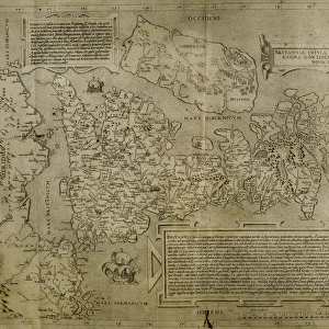
LEmpire du Cherif de Fez, Maroc, Sus &c. the Moroccan empire in the early 18th century, with the Atlas Mountains and the Sahara Date: 1719
Mary Evans Picture Library makes available wonderful images created for people to enjoy over the centuries
Media ID 20143953
© Bubblepunk
1719 Atlas Cherif Maps Maroc Moroccan Morocco Sahara
Glass Coaster
Individual Glass Coaster. Stylish and elegant polished safety glass, toughened and heat resistant (10x10cm, 7mm thick). Price shown is per individual coaster.
Individual Glass Coaster. Elegant polished safety toughened glass and heat resistant, matching Place Mats are also available
Estimated Image Size (if not cropped) is 5cm x 7.6cm (2" x 3")
Estimated Product Size is 10cm x 10cm (3.9" x 3.9")
These are individually made so all sizes are approximate
Artwork printed orientated as per the preview above, with portrait (vertical) orientation to match the source image.
FEATURES IN THESE COLLECTIONS
> Africa
> Morocco
> Related Images
> Africa
> Related Images
> Maps and Charts
> Early Maps
> Maps and Charts
> Related Images
> Mary Evans Prints Online
> New Images July 2020
EDITORS COMMENTS
This exquisite map print, titled "Empire du Cherif de Fez, Maroc, Sus &c." and dated 1719, offers a captivating glimpse into the Moroccan empire during the early 18th century. The map, from the Mary Evans Prints Online collection, provides a detailed and intricate depiction of Morocco's geography, with a focus on the regions of Fez, Maroc, and Sus. The map's central feature is the representation of the Atlas Mountains, a mountain range that stretches from northwest Africa through Algeria and Tunisia. The Atlas Mountains are depicted in stunning detail, with their peaks and valleys accurately rendered. The Sahara desert, to the south, is also shown, its vast expanse of sand dunes and oases contrasting sharply with the mountainous terrain to the north. The Moroccan empire at this time was ruled by the Alaouite dynasty, with the city of Fez serving as the spiritual and cultural center of the kingdom. The map reflects the empire's political divisions, with various provinces and territories labeled in intricate detail. The map also includes several notable cities, such as Marrakech, Rabat, and Tangier, as well as important landmarks, such as the Strait of Gibraltar and the Rif Mountains. The map's intricate detail and accurate representation of the geography of Morocco during this period make it an invaluable resource for historians, geographers, and anyone interested in the history of North Africa. The map's beautiful and ornate design, with its use of intricate cartouches and detailed border, adds to its aesthetic appeal and makes it a true work of art. Overall, this map print offers a fascinating glimpse into the Moroccan empire during the early 18th century, a time of political and cultural significance in North African history.
MADE IN THE UK
Safe Shipping with 30 Day Money Back Guarantee
FREE PERSONALISATION*
We are proud to offer a range of customisation features including Personalised Captions, Color Filters and Picture Zoom Tools
SECURE PAYMENTS
We happily accept a wide range of payment options so you can pay for the things you need in the way that is most convenient for you
* Options may vary by product and licensing agreement. Zoomed Pictures can be adjusted in the Basket.