Glass Coaster > Arts > Landscape paintings > Waterfall and river artworks > River artworks
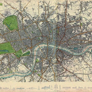
Glass Coaster : Historic map of London (18th Century)
")
")


![]()
Home Decor from Fine Art Storehouse
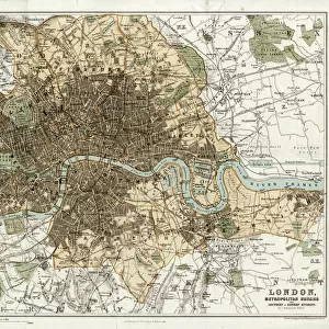
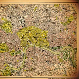
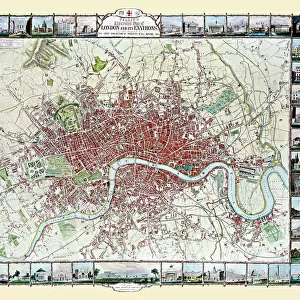
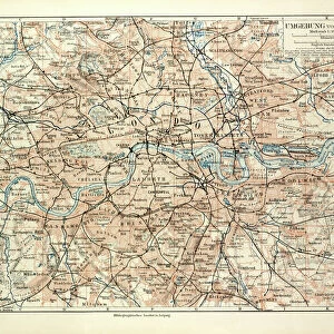
Historic map of London (18th Century)
map/plan of the inner city of London from 1898
Unleash your creativity and transform your space into a visual masterpiece!
Nastasic
Media ID 15241457
© Nikola Nastasic
City Map City Of London City Of Westminster Greater London Hyde Park London Image Created 1890 1899 Inner London Inside Of Kensington And Chelsea Lambeth London England Navigational Equipment Northern Europe Regents Park Sepia Toned Southeast England Styles Thames River Thoroughfare Urban Road Urban Scene Vignette Image Created 19th Century Obsolete Retro Styled Victorian Style
Glass Coaster
Individual Glass Coaster. Stylish and elegant polished safety glass, toughened and heat resistant (10x10cm, 7mm thick). Price shown is per individual coaster.
Individual Glass Coaster. Elegant polished safety toughened glass and heat resistant, matching Place Mats are also available
Estimated Image Size (if not cropped) is 7.6cm x 6.1cm (3" x 2.4")
Estimated Product Size is 10cm x 10cm (3.9" x 3.9")
These are individually made so all sizes are approximate
Artwork printed orientated as per the preview above, with landscape (horizontal) orientation to match the source image.
FEATURES IN THESE COLLECTIONS
> Fine Art Storehouse
> Map
> Historical Maps
> Arts
> Landscape paintings
> Waterfall and river artworks
> River artworks
> Arts
> Portraits
> Pop art gallery
> Street art portraits
> Europe
> Related Images
> Europe
> United Kingdom
> England
> Greater London
> Related Images
> Europe
> United Kingdom
> England
> London
> Boroughs
> City of London
> Europe
> United Kingdom
> England
> London
> Boroughs
> City of Westminster
> Europe
> United Kingdom
> England
> London
> Boroughs
> Kensington and Chelsea
> Europe
> United Kingdom
> England
> London
> Boroughs
> Lambeth
> Europe
> United Kingdom
> England
> London
> Related Images
> Europe
> United Kingdom
> England
> London
> River Thames
EDITORS COMMENTS
This print takes us back in time to the bustling streets of 18th century London. With its retro styling and vignette effect, it exudes a sense of nostalgia for a bygone era. The intricate details of this antique engraved image transport us to the heart of the city, offering a glimpse into its rich history. The map showcases the inner city of London as it stood in 1898, during the height of Victorian England. From Regents Park to Hyde Park, from Lambeth to Kensington and Chelsea, every corner is meticulously depicted with precision and artistry. It encompasses not only the City of Westminster but also Greater London itself. As we explore this sepia-toned urban scene, we are reminded that this was an age before modern navigational equipment guided our way. Instead, people relied on beautifully crafted maps like these to navigate their journeys through the winding streets and along the Thames River. This print serves as a testament to both cartography as an art form and London's enduring legacy as one of Europe's great cities. It invites us to immerse ourselves in history and appreciate how much has changed since those times gone by. As we gaze upon this illustration created over a century ago, we can't help but feel connected to those who once walked these same roads and experienced life in this vibrant metropolis known simply as London.
MADE IN THE UK
Safe Shipping with 30 Day Money Back Guarantee
FREE PERSONALISATION*
We are proud to offer a range of customisation features including Personalised Captions, Color Filters and Picture Zoom Tools
SECURE PAYMENTS
We happily accept a wide range of payment options so you can pay for the things you need in the way that is most convenient for you
* Options may vary by product and licensing agreement. Zoomed Pictures can be adjusted in the Basket.