Glass Coaster > Fine Art Finder > Maps (celestial & Terrestrial)
Glass Coaster : The Kingdome of England, engraved by Jodocus Hondius (1563-1612) from John Speed s
 from John Speed s")
 from John Speed s")


![]()
Home Decor from Fine Art Finder
The Kingdome of England, engraved by Jodocus Hondius (1563-1612) from John Speed s
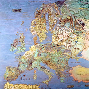
XCF113483 The Kingdome of England, engraved by Jodocus Hondius (1563-1612) from John Speeds Theatre of the Empire of Great Britain, pub. by John Sudbury and George Humble, 1611-12 (hand coloured copper engraving) by Speed, John (1552-1629); Private Collection; English, out of copyright
Media ID 12710179
© www.bridgemanart.com
1552 1629 Cartouche Classes Counties Crest Speed Types
Glass Coaster
Individual Glass Coaster. Stylish and elegant polished safety glass, toughened and heat resistant (10x10cm, 7mm thick). Price shown is per individual coaster.
Individual Glass Coaster. Elegant polished safety toughened glass and heat resistant, matching Place Mats are also available
Estimated Image Size (if not cropped) is 7.6cm x 5.8cm (3" x 2.3")
Estimated Product Size is 10cm x 10cm (3.9" x 3.9")
These are individually made so all sizes are approximate
Artwork printed orientated as per the preview above, with landscape (horizontal) orientation to match the source image.
FEATURES IN THESE COLLECTIONS
> Fine Art Finder
> Artists
> John Speed
> Fine Art Finder
> Maps (celestial & Terrestrial)
EDITORS COMMENTS
This print showcases "The Kingdome of England" an exquisite engraved map created by Jodocus Hondius in the late 16th century. The artwork is a part of John Speed's renowned publication, "Theatre of the Empire of Great Britain" which was published between 1611 and 1612. Hondius' masterful craftsmanship is evident in this hand-colored copper engraving, capturing the intricate details of each county within England. The map not only serves as a geographical representation but also provides a glimpse into the rich history and culture of this majestic kingdom. As one explores this remarkable piece, they are transported back in time to an era where cartography was both art and science. Each crest, coat of arms, and cartouche tells its own story, reflecting the diversity and uniqueness found throughout England's various regions. Moreover, the inclusion of different types and classes within English society adds depth to this visual narrative. From noble lords to common folk adorned in their distinctive costumes, every element contributes to painting a vivid picture of life during that period. This print from Fine Art Finder allows us to appreciate not only the artistic brilliance behind Hondius' work but also offers insight into how maps were used as tools for exploration and understanding centuries ago. It stands as a testament to our enduring fascination with history and geography while reminding us that even through time's passage, beauty can be preserved for generations to come.
MADE IN THE UK
Safe Shipping with 30 Day Money Back Guarantee
FREE PERSONALISATION*
We are proud to offer a range of customisation features including Personalised Captions, Color Filters and Picture Zoom Tools
SECURE PAYMENTS
We happily accept a wide range of payment options so you can pay for the things you need in the way that is most convenient for you
* Options may vary by product and licensing agreement. Zoomed Pictures can be adjusted in the Basket.