Glass Coaster > Animals > Birds > Passerines > Finches > Atlantic Canary
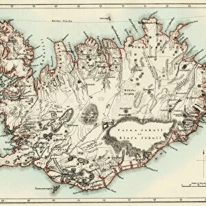
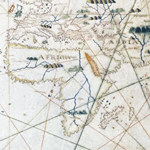
Glass Coaster : A Nautical Map, detail of the Canary Islands, 1564 (colour litho)
")
")


![]()
Home Decor from Fine Art Finder
A Nautical Map, detail of the Canary Islands, 1564 (colour litho)
955467 A Nautical Map, detail of the Canary Islands, 1564 (colour litho) by Maggiolo, Giacomo (16th Century); Biblioteca Civica Bertoliana, Vicenza, Italy; Alinari
Media ID 23527258
© Bridgeman Images
Archipelago Atlantic Canaries Canary Cartographic Coast Scenery Coastal Feature Coastl Compass Iceland Icelander Icelandic Islands Nautical Naval School Navigation Shipping Topographical Whole Window
Glass Coaster
Individual Glass Coaster. Stylish and elegant polished safety glass, toughened and heat resistant (10x10cm, 7mm thick). Price shown is per individual coaster.
Individual Glass Coaster. Elegant polished safety toughened glass and heat resistant, matching Place Mats are also available
Estimated Image Size (if not cropped) is 0.8cm x 7.6cm (0.3" x 3")
Estimated Product Size is 10cm x 10cm (3.9" x 3.9")
These are individually made so all sizes are approximate
Artwork printed orientated as per the preview above, with portrait (vertical) orientation to match the source image.
FEATURES IN THESE COLLECTIONS
> Fine Art Finder
> Artists
> French School
> Fine Art Finder
> Artists
> Giacomo Maggiolo
> Fine Art Finder
> Maps (celestial & Terrestrial)
> Fine Art Finder
> Temp Classification
> Animals
> Birds
> Passerines
> Finches
> Atlantic Canary
> Arts
> Art Movements
> Renaissance Art
> Arts
> Artists
> I
> Italian School Italian School
> Arts
> Artists
> O
> Oceanic Oceanic
> Arts
> Artists
> S
> Spanish School
> Europe
> Iceland
> Related Images
> Europe
> Italy
> Heritage Sites
> City of Vicenza and the Palladian
EDITORS COMMENTS
This print showcases a stunning detail of a nautical map depicting the Canary Islands in 1564. Created by the talented Italian cartographer Giacomo Maggiolo, this color lithograph offers a glimpse into the intricate world of maritime navigation during the Renaissance era. The map beautifully captures the archipelago's coastline, revealing its topographical features and highlighting its significance as a crucial point for Spanish shipping routes. The attention to detail is remarkable, with each island meticulously depicted along with compass markings and other navigational elements. As we delve into this historical artwork, we are transported back in time to an era when maps were not only practical tools but also works of art. The vibrant colors and precise lines evoke a sense of adventure and discovery that characterized European exploration during this period. The presence of naval ships further emphasizes the importance of these islands in terms of strategic military positioning. It serves as a reminder that beyond their natural beauty, these islands played a vital role in shaping history. Displayed proudly at Biblioteca Civica Bertoliana in Vicenza, Italy, this print allows us to appreciate both the artistic mastery behind it and its invaluable contribution to our understanding of geographical knowledge from centuries ago.
MADE IN THE UK
Safe Shipping with 30 Day Money Back Guarantee
FREE PERSONALISATION*
We are proud to offer a range of customisation features including Personalised Captions, Color Filters and Picture Zoom Tools
SECURE PAYMENTS
We happily accept a wide range of payment options so you can pay for the things you need in the way that is most convenient for you
* Options may vary by product and licensing agreement. Zoomed Pictures can be adjusted in the Basket.