Fraud Blocker Skip to main content

Demography Collection

"Exploring the Nighttime Demography: A Satellite Journey Across Continents" North America at night

Background imageDemography Collection: Europe at night, satellite image

Europe at night, satellite image. City lights (yellow) show areas of dense population. There are few lights in North Africa (bottom) and the Arctic (top) since they are more sparsely populated

Background imageDemography Collection: North America at night, satellite image

North America at night, satellite image
Africa at night. Satellite image of the Earth at night, set against a background of stars, centred on the continent of Africa. North is at top. City lights (yellow) show areas of dense population

Background imageDemography Collection: South America at night, satellite image

South America at night, satellite image
South America at night. Satellite image of the Earth at night, set against a background of stars, centred on the continent of South America. North is at top

Background imageDemography Collection: South America at night, satellite image

South America at night, satellite image. City lights (yellow) show areas of dense population, particularly in North America (top left) and South Americas coasts

Background imageDemography Collection: North America at night, satellite image

North America at night, satellite image. City lights (yellow) show areas of dense population, particularly in North America (upper centre)

Background imageDemography Collection: Southeast Asia at night, satellite image

Southeast Asia at night, satellite image
Southeast Asia at night. Satellite image of the Earth seen at 18:00 (6pm) GMT (UCT), centred on China. City lights (yellow) show areas of dense population, particularly in India (left)

Background imageDemography Collection: Africa, night-day satellite image

Africa, night-day satellite image. This composite image of the Earth is set against a background of stars, and is centred on the continent of Africa. North is at top

Background imageDemography Collection: Whole Earth at night, satellite image

Whole Earth at night, satellite image. This map is centred on the Greenwich meridian, at zero degrees latitude. City lights (yellow) show areas of dense population

Background imageDemography Collection: Australia at night, satellite image

Australia at night, satellite image. City lights (yellow) show areas of more dense population, particularly in Southeast Asia (top left) and on Australias east coast

Background imageDemography Collection: Title page of Principle of Population written by Thomas Robert Malthus

Title page of Principle of Population written by Thomas Robert Malthus
5312123 Title page of Principle of Population written by Thomas Robert Malthus; (add.info.: Title page of Principle of Population written by Thomas Robert Malthus)

Background imageDemography Collection: SPAIN. Sitges. Spanish Civil War (1936-1939)

SPAIN. Sitges. Spanish Civil War (1936-1939). Children summer camp in Sitges (1st May 1938). SPAIN. Madrid. Fundacion de Estudios Libertarios Anselmo Lorenzo (FAL)

Background imageDemography Collection: Depopulation and Repopulation in France, booklet by Arthur Le Creps against

Depopulation and Repopulation in France, booklet by Arthur Le Creps against
CHT220321 Depopulation and Repopulation in France, booklet by Arthur Le Creps against Malthusianism, 1895 (colour engraving) by French School, (19th century); Bibliotheque des Arts Decoratifs, Paris

Background imageDemography Collection: Density of distribution of the natives of Ireland and their proportion to the aggregate

Density of distribution of the natives of Ireland and their proportion to the aggregate
5848264 Density of distribution of the natives of Ireland and their proportion to the aggregate population, 1898 (print) by American School

Background imageDemography Collection: Depopulation and Repopulation in France, booklet by Arthur Le Creps against

Depopulation and Repopulation in France, booklet by Arthur Le Creps against
CHT164235 Depopulation and Repopulation in France, booklet by Arthur Le Creps against Malthusianism, 1895 (colour engraving) by French School, (19th century); Bibliotheque des Arts Decoratifs, Paris

Background imageDemography Collection: Physik Atlas, 1848 (colour litho)

Physik Atlas, 1848 (colour litho)
1265898 Physik Atlas, 1848 (colour litho) by Berghaus, Heinrich (1797-1884); Newberry Library, Chicago, Illinois, USA; eNewberry Library; German, out of copyright

Background imageDemography Collection: Taking the Census, 1854 (oil on canvas)

Taking the Census, 1854 (oil on canvas)
3613966 Taking the Census, 1854 (oil on canvas) by Edmonds, Francis William (1806-63); 71.1x96.5 cm; Metropolitan Museum of Art, New York

Background imageDemography Collection: Europe, night-day satellite image

Europe, night-day satellite image. This composite image of the Earth is set against a background of stars, and is centred on Europe. North is at top

Background imageDemography Collection: Map of religious affiliation in Germany, lithograph, published in 1897

Map of religious affiliation in Germany, lithograph, published in 1897
Map of the religious affiliation in Germany at the end of the 19th century. Lithograph, published in 1897

Background imageDemography Collection: Africa at night, satellite image

Africa at night, satellite image. City lights (yellow) show areas of dense population, particularly in Europe and the Middle East (top)

Background imageDemography Collection: East Asia at night, satellite image

East Asia at night, satellite image
East Asia at night. Satellite image of the Earth at night, centred over China. City lights (yellow) show areas of dense population

Background imageDemography Collection: Distribution of the Jews in Germany, lithograph, published in 1897

Distribution of the Jews in Germany, lithograph, published in 1897
Map of the distribution of the Jews in Germany at the end of the 19th century. Lithograph, published in 1897

Background imageDemography Collection: ENGLAND (19 century). London. India Company. Engraving

ENGLAND (19 century). London. India Company. Engraving
ENGLAND (19 century). London. East India Company. Engraving. SPAIN. CATALONIA. Barcelona. Biblioteca de Catalunya (National Library of Catalonia)

Background imageDemography Collection: VILANOVA i PIERA, Joan (1821-1893). Agronomic map

VILANOVA i PIERA, Joan (1821-1893). Agronomic map of Madrid municipal area. SPAIN. MADRID (AUTONOMOUS COMMUNITY). Madrid. Instituto Geol󧩣 o y Minero de Espa

Background imageDemography Collection: Peru. Lima. Engraving

Peru. Lima. Engraving
Lima in 1850. Engraving

Background imageDemography Collection: BOBERG, Ferdinand. S�District

BOBERG, Ferdinand. S�District
BOBERG, Ferdinand (1860-1946). S� District. 1927. Watercolour. SWEDEN. Stockholm. The Nacional Museum of Fine Arts

Background imageDemography Collection: Barcelona. Citadel tower. Engraving

Barcelona. Citadel tower. Engraving
Tower of the Citadel of Barcelona in 19th c. Engraving. SPAIN. CATALONIA. Barcelona. Barcelona City History Museum

Background imageDemography Collection: FRANKLIN: TITLE PAGE, 1751. First page of Benjamin Franklins essay, Observations

FRANKLIN: TITLE PAGE, 1751. First page of Benjamin Franklins essay, Observations Concerning the Increase of Mankind, Peopling of Countries, etc. 1751

Background imageDemography Collection: Title page of mortality bill for London for 1664 / 5, covering part of the period of the Great

Title page of mortality bill for London for 1664 / 5, covering part of the period of the Great Plague
Title page of mortality bill for London for 1664/5, covering part of the period of the Great Plague. John Graunt (1620-1674) based his statistical analysis on these weekly and yearly tables

Background imageDemography Collection: Earths population, artwork

Earths population, artwork
Earths population. Computer artwork showing the number of people per square kilometre (grid) across the globe. The most densely populated areas are bright red

Background imageDemography Collection: Prague in 18th c. Drawing. CZECH Rep Prague

Prague in 18th c. Drawing. CZECH Rep Prague
Prague in 18th c. Drawing. CZECH Rep.. Prague

Background imageDemography Collection: Venice (17th c. ). Detail of Saint Marks Square

Venice (17th c. ). Detail of Saint Marks Square
Venice (17th c.). Detail of Saint Marks Square

Background imageDemography Collection: Map of Freiburg im Breisgau (17th c. ). Engraving

Map of Freiburg im Breisgau (17th c. ). Engraving
Map of Freiburg im Breisgau (17th c.). Engraving

Background imageDemography Collection: Badajoz (1812). Litography. SPAIN. Madrid. National

Badajoz (1812). Litography. SPAIN. Madrid. National Library

Background imageDemography Collection: The city and port of Barcelona (18th c. ). Engraving

The city and port of Barcelona (18th c. ). Engraving
The city and port of Barcelona (18th c.). Engraving

Background imageDemography Collection: Frontis Malthus Principle of Population

Frontis Malthus Principle of Population
Frontis plate from the 1826 Sixth edition of Malthus " Principle of Population". This is the edition which was read by Charles Darwin

Background imageDemography Collection: 1736 Edmond Halley astronomer & physicist 1736 Edmond Halley astronomer & physicist

1736 Edmond Halley astronomer & physicist 1736 Edmond Halley astronomer & physicist
Edmond Halley astronomer and physicist (8 November 1656 - 14 January 1742). 1832 Engraving by W.D. Fry in the " Gallery of Portraits" after the painting by Dahl 1736 at age 80 with later

Background imageDemography Collection: Europe at night, satellite image

Europe at night, satellite image
Europe at night. Satellite image of the Earth seen at 00:00 (midnight) GMT (UTC), centred on Europe. City lights (yellow) in dark areas show areas of dense population

Background imageDemography Collection: The Americas, satellite image

The Americas, satellite image. Oceans are blue and land is green and brown. City lights (yellow) in dark areas show areas of dense population

Background imageDemography Collection: The Arctic, night-day satellite image

The Arctic, night-day satellite image
Asia, night-day satellite image. This composite image of the Earth is set against a background of stars, and is centred on the continent of Asia. North is at top

Background imageDemography Collection: Asia at night, satellite image

Asia at night, satellite image. City lights (yellow) show areas of dense population. Large, densely populated areas include India (lower centre), China (lower right) and Japan (right)


All Professionally Made to Order for Quick Shipping

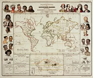
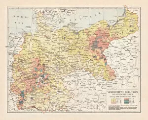
"Exploring the Nighttime Demography: A Satellite Journey Across Continents" North America at night, satellite image: Witness the vibrant tapestry of lights illuminating North America as darkness falls. This captivating satellite image unveils the diverse demography that thrives across this vast continent. Europe at night, satellite image: Behold the enchanting sight of Europe sparkling under a starry sky. From bustling cities to tranquil villages, this mesmerizing satellite image reflects the rich demographic mosaic that defines this culturally diverse continent. South America at night, satellite image: As daylight fades over South America, witness a breathtaking spectacle from above. This stunning satellite image showcases the dynamic demographics and urban landscapes that shape this vibrant region. Southeast Asia at night, satellite image: Embark on an awe-inspiring journey through Southeast Asia after sunset with this captivating satellite image. Marvel at how various demographics coexist amidst bustling metropolises and serene rural areas. Africa, night-day satellite image: Experience the contrasting beauty of Africa in one extraordinary snapshot – a blend of nighttime allure and daytime vibrancy captured by satellites overhead. Discover how demographics thrive across this vast continent day and night. Whole Earth at night, satellite image: Gaze upon our planet like never before with an astonishing view from space during nighttime hours. This remarkable composite picture reveals global demography patterns as lights twinkle across continents and oceans alike. Australia at night, satellite image: Delve into Australia's nocturnal charm with a strikingly vivid aerial perspective captured by satellites above its vast expanse. Explore how demographics shape both urban centers and remote regions down under. SPAIN Sitges Spanish Civil War (1936-1939): Unearth Spain's historical past through an evocative lens - delve into Sitges' role during the Spanish Civil War (1936-1939). Understand how conflicts can reshape demographics and leave lasting imprints on communities.