Fraud Blocker Skip to main content

Caribbean Collection (page 17)

"Discover the Vibrant Spirit of the Caribbean: A Tapestry of Cultures and Natural Wonders" Jamaicans on board the Empire Windrush

Background imageCaribbean Collection: Santo Domingo, 1796

Santo Domingo, 1796
2902892 Santo Domingo, 1796; (add.info.: Santo Domingo, Dominican Republic, 1796.); Buyenlarge Archive/UIG.

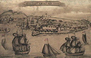
Background imageCaribbean Collection: Panorama of harbor showing siege of Curacao by English sailors and soldiers in 1800

Panorama of harbor showing siege of Curacao by English sailors and soldiers in 1800
2902887 Panorama of harbor showing siege of Curacao by English sailors and soldiers in 1800; (add.info.: Panorama of harbor showing siege of Curacao by English sailors and soldiers in 1800)

Background imageCaribbean Collection: Chart of the West Indies, 1796

Chart of the West Indies, 1796
2902871 Chart of the West Indies, 1796; (add.info.: Chart of the West Indies, 1796.); Buyenlarge Archive/UIG.

Background imageCaribbean Collection: Map showing the Gulf of Paria or De La Ballena as Christopher Columbus named it on his third

Map showing the Gulf of Paria or De La Ballena as Christopher Columbus named it on his third voyage, 1892 (print)
2915323 Map showing the Gulf of Paria or De La Ballena as Christopher Columbus named it on his third voyage, 1892 (print); (add.info.: From the book Life of Christopher Columbus by Clements R)

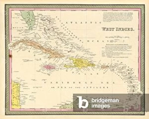
Background imageCaribbean Collection: West Indies, 1849

West Indies, 1849
2902888 West Indies, 1849; (add.info.: West Indies, 1849.); Buyenlarge Archive/UIG.

Background imageCaribbean Collection: Caribbean pygmymelon, Psiguria pedata (Anguria pedata). Handcoloured copperplate engraving after

Caribbean pygmymelon, Psiguria pedata (Anguria pedata). Handcoloured copperplate engraving after an illustration by
FLO4618390 Caribbean pygmymelon, Psiguria pedata (Anguria pedata). Handcoloured copperplate engraving after an illustration by Richard Duppa from his The Clours

Background imageCaribbean Collection: Idols and axe or buton of the Island Carib or Kalinago people

Idols and axe or buton of the Island Carib or Kalinago people. Handcoloured copperplate engraving from Giulio
FLO4621613 Idols and axe or buton of the Island Carib or Kalinago people. Handcoloured copperplate engraving from Giulio Ferrario's Costumes Antique and Modern of All Peoples

Background imageCaribbean Collection: Hammock, rattan basketball, cassava beer-fermenting net, and other utensils made by the Island

Hammock, rattan basketball, cassava beer-fermenting net, and other utensils made by the Island Carib or Kalinago
FLO4621597 Hammock, rattan basketball, cassava beer-fermenting net, and other utensils made by the Island Carib or Kalinago people, West Indies

Background imageCaribbean Collection: Crantzia tigrina (Heintzia tigrina). Native to Caracas, Venezuela

Crantzia tigrina (Heintzia tigrina). Native to Caracas, Venezuela. Handcoloured lithograph from Louis van Houtte
FLO4628584 Crantzia tigrina (Heintzia tigrina). Native to Caracas, Venezuela. Handcoloured lithograph from Louis van Houtte and Charles Lemaire's Flowers of the Gardens and Hothouses of Europe

Background imageCaribbean Collection: Portrait and signature of Francois Dominique Toussaint dit 'Toussaint-Louverture'

Portrait and signature of Francois Dominique Toussaint dit "Toussaint-Louverture" (Toussaint Louverture)
PCT4272266 Portrait and signature of Francois Dominique Toussaint dit "Toussaint-Louverture" (Toussaint Louverture, 1743-1803), a Haitian statesman

Background imageCaribbean Collection: Cupid's bower, Achimenes erecta, native of the Caribbean. Handcoloured stipple engraving on copper

Cupid's bower, Achimenes erecta, native of the Caribbean. Handcoloured stipple engraving on copper by Barrois
FLO4569567 Cupid's bower, Achimenes erecta, native of the Caribbean. Handcoloured stipple engraving on copper by Barrois from a botanical illustration by Pancrace Bessa from Mordant de

Background imageCaribbean Collection: Singapore holly, Malpighia coccigera, native to the Caribbean

Singapore holly, Malpighia coccigera, native to the Caribbean. Handcoloured stipple engraving on copper by Barrois
FLO4569557 Singapore holly, Malpighia coccigera, native to the Caribbean. Handcoloured stipple engraving on copper by Barrois from a botanical illustration by Pancrace Bessa from Mordant de

Background imageCaribbean Collection: Giant cabuya - choca vert or cadere - Furcraea foetida (Fourcroya gigantea), flower A

Giant cabuya - choca vert or cadere - Furcraea foetida (Fourcroya gigantea), flower A, native to the Caribbean
FLO4576753 Giant cabuya - choca vert or cadere - Furcraea foetida (Fourcroya gigantea), flower A, native to the Caribbean

Background imageCaribbean Collection: Universal Geography: the West Indies. Advertising images edited for the brand Louit

Universal Geography: the West Indies. Advertising images edited for the brand Louit. Debut 20th century. (lithograph)
DUV4218177 Universal Geography: the West Indies. Advertising images edited for the brand Louit. Debut 20th century. (lithograph); 9.5x6.5 cm; Photo © Duvallon.

Background imageCaribbean Collection: Common smoothhand, Mustelus mustelus, Vulnerable 1, angler fish, Lophius piscatorius 2, burrfish

Common smoothhand, Mustelus mustelus, Vulnerable 1, angler fish, Lophius piscatorius 2, burrfish
FLO4652692 Common smoothhand, Mustelus mustelus, Vulnerable 1, angler fish, Lophius piscatorius 2, burrfish, Chilomycterus schoepfi 3, and bill of a sawfish, Pristis pectinata

Background imageCaribbean Collection: Engraving depicting a Carolina anole, an arboreal lizard found primarily in the south-eastern

Engraving depicting a Carolina anole, an arboreal lizard found primarily in the south-eastern United States
5308950 Engraving depicting a Carolina anole, an arboreal lizard found primarily in the south-eastern United States and some Caribbean islands

Background imageCaribbean Collection: The Battle of the Saints, 12 April 1782, end of the action, 1782 (oil on canvas)

The Battle of the Saints, 12 April 1782, end of the action, 1782 (oil on canvas)
7337668 The Battle of the Saints, 12 April 1782, end of the action, 1782 (oil on canvas) by Whitcombe, Thomas (1760-1824); 78.7x127 cm; National Maritime Museum, London

Background imageCaribbean Collection: Quasi-war (Quasi-war) (1798-1800): naval battle between the American ship 'Boston'

Quasi-war (Quasi-war) (1798-1800): naval battle between the American ship "Boston"
NWI4839908 Quasi-war (Quasi-war) (1798-1800): naval battle between the American ship "Boston" and the French ship "Le Cradle", in the Caribbean Sea, around 1800

Background imageCaribbean Collection: English West Indies - French Antilles - Le Francois, Habitation Clement, Domaine de l'Mahogany

English West Indies - French Antilles - Le Francois, Habitation Clement, Domaine de l'Mahogany
JEB4949605 English West Indies - French Antilles - Le Francois, Habitation Clement, Domaine de l'Mahogany. Homere Clement (1858-1923), Doctor of Medicine in 1878, Mayor of the Francois 1885-1923

Background imageCaribbean Collection: French West Indies - French Antilles - Fonds Saint Jacques, Sugar Housing du Pere Labat (1663-1736)

French West Indies - French Antilles - Fonds Saint Jacques, Sugar Housing du Pere Labat (1663-1736)
JEB4950121 French West Indies - French Antilles - Fonds Saint Jacques, Sugar Housing du Pere Labat (1663-1736). Cane mill - Martinique

Background imageCaribbean Collection: French West Indies - French Antilles - Fonds Saint Jacques, Sugar Housing du Pere Labat (1663-1736)

French West Indies - French Antilles - Fonds Saint Jacques, Sugar Housing du Pere Labat (1663-1736) - Martinique
JEB4950068 French West Indies - French Antilles - Fonds Saint Jacques, Sugar Housing du Pere Labat (1663-1736) - Martinique

Background imageCaribbean Collection: Trois Ilets, Domaine de la Pagerie, Bust of Josephine de Beauharnais - Martinique

Trois Ilets, Domaine de la Pagerie, Bust of Josephine de Beauharnais - Martinique, island of the French Antilles
JEB4949222 Trois Ilets, Domaine de la Pagerie, Bust of Josephine de Beauharnais - Martinique, island of the French Antilles; (add.info.: Trois Ilets, Domaine de la Pagerie)

Background imageCaribbean Collection: French West Indies - French Antilles - La Trinite, Le chateau Dubuc was built in 1721

French West Indies - French Antilles - La Trinite, Le chateau Dubuc was built in 1721, by Louis du Buc du Galion
JEB4949096 French West Indies - French Antilles - La Trinite, Le chateau Dubuc was built in 1721, by Louis du Buc du Galion, grandson of Pierre du Buc, Sieur de La Caravelle et du Marigot

Background imageCaribbean Collection: French West Indies - French Antilles - Fort de France, cathedrale Saint Louis inspired by

French West Indies - French Antilles - Fort de France, cathedrale Saint Louis inspired by the Eiffel style
JEB4948748 French West Indies - French Antilles - Fort de France, cathedrale Saint Louis inspired by the Eiffel style. Its construction began in 1893 under the direction of Pierre Henri Picq

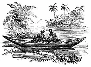
Background imageCaribbean Collection: A canoe being used by Island Caribs, 1850

A canoe being used by Island Caribs, 1850
3330590 A canoe being used by Island Caribs, 1850; (add.info.: Engraving depicting a canoe being used by Island Caribs, an indigenous peoples of the Lesser Antilles in the Caribbean)

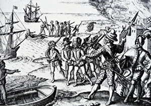
Background imageCaribbean Collection: Sir Walter Raleigh's Conquest of the City of St Joseph in the Isle of Trinidad

Sir Walter Raleigh's Conquest of the City of St Joseph in the Isle of Trinidad
3329529 Sir Walter Raleigh's Conquest of the City of St Joseph in the Isle of Trinidad; (add.info.: Engraving depicting Sir Walter Raleigh's Conquest of the City of St Joseph in the Isle of)

Background imageCaribbean Collection: Map of the island of Hispaniola (Santo Domingo or Haiti), Caribbean Sea

Map of the island of Hispaniola (Santo Domingo or Haiti), Caribbean Sea, circa 1870 - Lithograph 19th century
NWI4866878 Map of the island of Hispaniola (Santo Domingo or Haiti), Caribbean Sea, circa 1870 - Lithograph 19th century (Map of Hispaniola, including Haiti and Santo Domingo, 1870s)

Background imageCaribbean Collection: Geography map: double page of an Atlas showing maps and descriptive texts of the islands of Jamaica

Geography map: double page of an Atlas showing maps and descriptive texts of the islands of Jamaica
VEN5030435 Geography map: double page of an Atlas showing maps and descriptive texts of the islands of Jamaica and Cuba in the Caribbean. Engraving of the 17th century

Background imageCaribbean Collection: Geography map: representation of the southern island of Cuba and the island of Hispaniola

Geography map: representation of the southern island of Cuba and the island of Hispaniola and the small Caribbean
VEN5030180 Geography map: representation of the southern island of Cuba and the island of Hispaniola and the small Caribbean, made by the Dutch cartographer Gerard van Keulen (1678-1726) 1709-1713

Background imageCaribbean Collection: Geography Atlas: representation of the island of Hispaniola (which includes Santo Domingo and Haiti)

Geography Atlas: representation of the island of Hispaniola (which includes Santo Domingo and Haiti)
VEN5031366 Geography Atlas: representation of the island of Hispaniola (which includes Santo Domingo and Haiti) in the Caribbean archipelago. Map by the Knight Lapie, 1819

Background imageCaribbean Collection: Geography Atlas: representation of the island of Santo Domingo

Geography Atlas: representation of the island of Santo Domingo, the Bahamas of Puerto Rico to the West Indies
VEN5031345 Geography Atlas: representation of the island of Santo Domingo, the Bahamas of Puerto Rico to the West Indies. Map from an atlas of 1867

Background imageCaribbean Collection: Geography: map showing the Gulf of Mexico and the Caribbean Sea islands (Caribbean)

Geography: map showing the Gulf of Mexico and the Caribbean Sea islands (Caribbean)
VEN5031257 Geography: map showing the Gulf of Mexico and the Caribbean Sea islands (Caribbean). Plate taken from an Atlas by Philippe Buache (1700-1773) 1780

Background imageCaribbean Collection: Geography Atlas: description of the Caribbean Sea, Caribbean Sea (Cuba, Jamaica, Hispaniola)

Geography Atlas: description of the Caribbean Sea, Caribbean Sea (Cuba, Jamaica, Hispaniola, Jamaica)
VEN5031247 Geography Atlas: description of the Caribbean Sea, Caribbean Sea (Cuba, Jamaica, Hispaniola, Jamaica), the Bahamas Islands and the Lesser Antilles with map

Background imageCaribbean Collection: Geography: map showing Central America (Mexico, Honduras, Yucatan)

Geography: map showing Central America (Mexico, Honduras, Yucatan) and the Caribbean Sea Islands (Antilles)
VEN5031211 Geography: map showing Central America (Mexico, Honduras, Yucatan) and the Caribbean Sea Islands (Antilles). Plate from a British Atlas of 1737

Background imageCaribbean Collection: Geography: map of the islands of Central America (Antilles), the Detroit of Panama

Geography: map of the islands of Central America (Antilles), the Detroit of Panama and representation of Mexico City
VEN5031188 Geography: map of the islands of Central America (Antilles), the Detroit of Panama and representation of Mexico City

Background imageCaribbean Collection: Geography: representation of the island of Hispaniola with the east coast of the island of Cuba in

Geography: representation of the island of Hispaniola with the east coast of the island of Cuba in the Caribbean Sea
VEN5031183 Geography: representation of the island of Hispaniola with the east coast of the island of Cuba in the Caribbean Sea

Background imageCaribbean Collection: Geography Atlas: representation of the region of the Caribbean Sea, the Greater Antilles (Cuba)

Geography Atlas: representation of the region of the Caribbean Sea, the Greater Antilles (Cuba, Jamaica)
VEN5030081 Geography Atlas: representation of the region of the Caribbean Sea, the Greater Antilles (Cuba, Jamaica, Hispaniola) and the small Antilles with colours indicating membership to France

Background imageCaribbean Collection: Geography Atlas: representation of the Caribbean Sea region, the Caribbean (Cuba, Jamaica)

Geography Atlas: representation of the Caribbean Sea region, the Caribbean (Cuba, Jamaica)
VEN5030071 Geography Atlas: representation of the Caribbean Sea region, the Caribbean (Cuba, Jamaica, Hispaniola) and the Lesser Antilles. Map from an Atlas of 1637

Background imageCaribbean Collection: Geography Atlas: representation of North America and the Caribbean Sea region, Caribbean (Cuba)

Geography Atlas: representation of North America and the Caribbean Sea region, Caribbean (Cuba, Jamaica, Hispaniola)
VEN5030064 Geography Atlas: representation of North America and the Caribbean Sea region, Caribbean (Cuba, Jamaica, Hispaniola, Jamaica). Map from an Atlas by Adrien Hubert Brue (1786-1832), 1821

Background imageCaribbean Collection: Geography Atlas: representation of the Caribbean archipelago (Cuba, Hispaniola, Puerto Rico)

Geography Atlas: representation of the Caribbean archipelago (Cuba, Hispaniola, Puerto Rico), the Bahamas Islands
VEN5030034 Geography Atlas: representation of the Caribbean archipelago (Cuba, Hispaniola, Puerto Rico), the Bahamas Islands. Map from a Spanish Atlas of 1825

Background imageCaribbean Collection: Geography Atlas: representation of the island of Hispaniola (which includes Santo Domingo and Haiti)

Geography Atlas: representation of the island of Hispaniola (which includes Santo Domingo and Haiti)
VEN5030030 Geography Atlas: representation of the island of Hispaniola (which includes Santo Domingo and Haiti) in the Caribbean archipelago

Background imageCaribbean Collection: Geography Atlas: representation of the island of Saint Lucia (Antilles)

Geography Atlas: representation of the island of Saint Lucia (Antilles). Map taken from "The west indian atlas or
VEN5030018 Geography Atlas: representation of the island of Saint Lucia (Antilles). Map taken from "The west indian atlas or general description of west indies" by Thomas Jefferys

Background imageCaribbean Collection: Geography Atlas: representation of the island of Jamaica (Antilles)

Geography Atlas: representation of the island of Jamaica (Antilles). Map taken from "The west indian atlas or
VEN5030010 Geography Atlas: representation of the island of Jamaica (Antilles). Map taken from "The west indian atlas or general description of west indies" by Thomas Jefferys

Background imageCaribbean Collection: Alonso de Ojeda (1468-1515), Spanish navigator captured the Indian chief Caonabo to take him to

Alonso de Ojeda (1468-1515), Spanish navigator captured the Indian chief Caonabo to take him to Queen Isabella in
NWI4903953 Alonso de Ojeda (1468-1515), Spanish navigator captured the Indian chief Caonabo to take him to Queen Isabella in Spain. Engraving

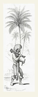
Background imageCaribbean Collection: A member of the Carib tribe of Dutch Guyana, south America in the 19th century

A member of the Carib tribe of Dutch Guyana, south America in the 19th century
3252971 A member of the Carib tribe of Dutch Guyana, south America in the 19th century; (add.info.: A member of the Carib tribe of Dutch Guyana, south America in the 19th century)

Background imageCaribbean Collection: Harvesting of tree's resin called chibou, cachibou or gomartis or gum or mastic

Harvesting of tree's resin called chibou, cachibou or gomartis or gum or mastic on the gumbo-limbo, copperwood
ELD4919328 Harvesting of tree's resin called chibou, cachibou or gomartis or gum or mastic on the gumbo-limbo, copperwood, chaca

Background imageCaribbean Collection: Map of the New World in 1511 (Caribbean Sea, Central America)

Map of the New World in 1511 (Caribbean Sea, Central America), with the first representation of the Bermuda Archipelago
NWI4853682 Map of the New World in 1511 (Caribbean Sea, Central America), with the first representation of the Bermuda Archipelago discovered in 1505 - Colorful engraving after the account of Pierre

Background imageCaribbean Collection: Spanish Caribbean Cup hilted rapier

Spanish Caribbean Cup hilted rapier
3029977 Spanish Caribbean Cup hilted rapier; Private Collection; (add.info.: Spanish Caribbean Cup hilted rapier, often used by pirates and buccaneers)


All Professionally Made to Order for Quick Shipping

"Discover the Vibrant Spirit of the Caribbean: A Tapestry of Cultures and Natural Wonders" Jamaicans on board the Empire Windrush: Celebrating the rich heritage and resilience brought by Jamaican immigrants, who embarked on a journey that forever shaped the Caribbean's cultural landscape. Small airplane landing at the airport of St. Barth (Saint Barthelemy), Lesser Antilles: Unveiling breathtaking views as you touch down in this idyllic island paradise, where luxury meets tranquility in perfect harmony. Cruz Bay, St. John, U. S. Virgin Islands, West Indies, Caribbean: Immerse yourself in the laid-back charm of this picturesque town nestled amidst lush greenery and crystal-clear waters – a true slice of heaven. Dunns River Falls, Ocho Rios, Jamaica: Feel your heart race as you climb these majestic cascades surrounded by verdant tropical foliage – an exhilarating adventure that captures Jamaica's natural beauty. Hammock hanging on famous White Bay, Jost Van Dyke, British Virgin Islands: Surrender to pure bliss as you sway gently in a hammock overlooking pristine white sands and turquoise waters – an oasis for relaxation seekers. The Pitons, St. Lucia: Marvel at nature's masterpiece - two towering volcanic peaks rising majestically from azure seas - a UNESCO World Heritage site that embodies Saint Lucia's dramatic allure. Divi Divi Trees on Eagle Beach, Aruba: Find solace under these iconic bent trees while basking in Aruba's year-round sunshine – an invitation to unwind amidst stunning coastal scenery. Poster advertising Royal Mail Lines to the West Indies: Step back in time through vintage artwork showcasing glamorous ocean voyages that once connected travelers with exotic destinations across the West Indies' archipelago. Cinnamon Bay beach and palms, St. John, U. S. Virgin Islands.