Framed Print > Arts > Artists > P > John Parker
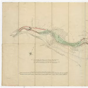
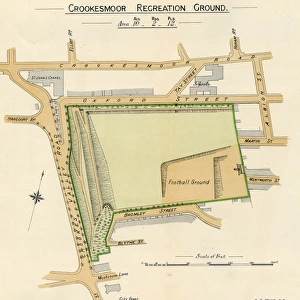
Framed Print : A map of the lands at and near Crooks [Crookes] part in Ecclesall and part in Nether Hallam, 1790
![A map of the lands at and near Crooks [Crookes] part in Ecclesall and part in Nether Hallam, 1790](/image/716/14049486/14049486_600_600_80876_736_fit_0_a1fcbbcf461e6ba38047b75135aa3dc3.jpg.webp "A map of the lands at and near Crooks [Crookes] part in Ecclesall and part in Nether Hallam, 1790")


![A map of the lands at and near Crooks [Crookes] part in Ecclesall and part in Nether Hallam, 1790](/p/716/map-lands-near-crooks-crookes-ecclesall-nether-14049486.jpg.webp "A map of the lands at and near Crooks [Crookes] part in Ecclesall and part in Nether Hallam, 1790")


![]()
Framed Photos from Sheffield City Archives
A map of the lands at and near Crooks [Crookes] part in Ecclesall and part in Nether Hallam, 1790
Scale: 26 inches : 1 mile.Surveyor: William Fairbank II.The old open fields, with some of the strips still open, but mostly enclosed, bounded by Walkley Bank, Crookesmoor, Lydgate and Steel Bank; colours distinguish the lands of the Duke of Norfolk, John Parker and John Spooner, and other owners are given on the map; a few acreages given on the map; fields, etc. numbered, with reference to a survey of 1790.The numerical and alphabetical survey is in the Fairbank Collection, ME 472.Original at Sheffield Archives ACM/MAPS/SheD/832
Sheffield City Archives and Local Studies Library has an unrivalled collection of images of Sheffield, England
Media ID 14049486
© Sheffield City Council
Bank Crookes House Maps Road Street Walkley Harper Lydgate
14"x12" (38x32cm) Modern Frame
Discover the rich history of Sheffield with this beautiful framed print from Media Storehouse. Featuring a rare map of Crookes part in Ecclesall and Nether Hallam, dated 1790, this detailed and intriguing piece showcases the open fields and enclosed lands as surveyed by William Fairbank II. With a scale of 26 inches to 1 mile, this vintage map offers a unique glimpse into the past, bound by Walkley Bank and Crookesmoor. Bring history into your home with this exquisite framed print.
Wood effect frame, card mounted, 10x8 archival quality photo print. Overall outside dimensions 14x12 inches (38x32cm). Environmentally and ozone friendly, 40mm wide x 15mm Polycore® moulding has the look of real wood, is durable and light and easy to hang. Biodegradable and made with non-chlorinated gases (no toxic fumes) it is efficient; producing 100 tons of polystyrene can save 300 tons of trees! Prints are glazed with lightweight, shatterproof, optical clarity acrylic (providing the same general protection from the environment as glass). The back is stapled hardboard with a sawtooth hanger attached. Note: To minimise original artwork cropping, for optimum layout, and to ensure print is secure, the visible print may be marginally smaller
Contemporary Framed and Mounted Prints - Professionally Made and Ready to Hang
Estimated Image Size (if not cropped) is 24.4cm x 16.9cm (9.6" x 6.7")
Estimated Product Size is 37.6cm x 32.5cm (14.8" x 12.8")
These are individually made so all sizes are approximate
Artwork printed orientated as per the preview above, with landscape (horizontal) orientation to match the source image.
FEATURES IN THESE COLLECTIONS
> Arts
> Artists
> F
> John Field
> Arts
> Artists
> P
> John Parker
> Europe
> United Kingdom
> England
> Norfolk
> Related Images
> Maps and Charts
> Related Images
> Sheffield City Archives
> Maps and Plans
EDITORS COMMENTS
This print showcases a historical map dating back to 1790, titled "A map of the lands at and near Crookes part in Ecclesall and part in Nether Hallam". The intricate details on this map were meticulously surveyed by William Fairbank II, with a scale of 26 inches to 1 mile. The map vividly depicts the old open fields that once graced this area, now mostly enclosed but still revealing traces of their former glory. Bounded by Walkley Bank, Crookesmoor, Lydgate, and Steel Bank, it offers an intriguing glimpse into the past. Different colors distinguish the lands owned by notable figures such as the Duke of Norfolk, John Parker, John Spooner, and other landowners whose names are carefully marked on the map. Additionally, this remarkable piece provides numerical references to a survey conducted in 1790. Each field is numbered and labeled accordingly for easy identification. For those interested in delving deeper into this historical record's rich content or conducting further research about these lands' history and ownership patterns can refer to the Fairbank Collection (ME 472) at Sheffield Archives. Preserved within Sheffield City Archives ACM/MAPS/SheD/832 collection today is an original copy of this invaluable artifact that sheds light on how these landscapes have evolved over time. It serves as a testament to our shared heritage while offering glimpses into a world long gone - one where vast open fields stretched across what we now know as Crookes
MADE IN THE UK
Safe Shipping with 30 Day Money Back Guarantee
FREE PERSONALISATION*
We are proud to offer a range of customisation features including Personalised Captions, Color Filters and Picture Zoom Tools
SECURE PAYMENTS
We happily accept a wide range of payment options so you can pay for the things you need in the way that is most convenient for you
* Options may vary by product and licensing agreement. Zoomed Pictures can be adjusted in the Basket.


![Plan of Freehold Estate at Crookes Moor [Crookesmoor] belonging to the executors of the late P Ashberry esquire, as laid out for building purposes, 1881](/sq/716/plan-freehold-estate-crookes-moor-crookesmoor-14049212.jpg.webp)