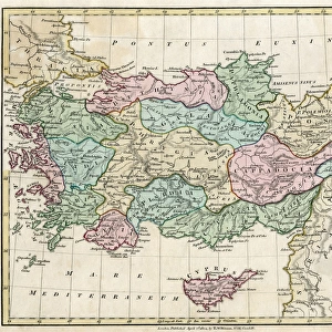
Framed Print : Portolan Atlas, 1587. Map of Asia, from Armenia


![]()
Framed Photos from Mary Evans Picture Library
Portolan Atlas, 1587. Map of Asia, from Armenia
Portolan Atlas, 1587. Map of Asia, from Armenia, Iran, Afghanistan to the Indus River. Made in Messina. Facsimile. Miniature Painting. SPAIN. Madrid. National Library
Mary Evans Picture Library makes available wonderful images created for people to enjoy over the centuries
Media ID 8270551
© Mary Evans Picture Library 2015 - https://copyrighthub.org/s0/hub1/creation/maryevans/MaryEvansPictureID/10686813
Afghanistan Armenia Atlas Compass Facsimile Geographic Illuminated Indus Iran Manuscript Manuscripts Messina Miniatures Portolan Made
14"x12" (38x32cm) Modern Frame
Introducing the latest addition to our Framed Prints collection at Media Storehouse: The Portolan Atlas, 1587. Map of Asia, from Armenia. This exquisite print is a reproduction of an original miniature painting from the National Library in Madrid, Spain. Dating back to the late 16th century, this Portolan Atlas is a testament to the rich cartographic history of the time. The map covers a vast expanse of Asia, from Armenia to the Indus River, showcasing intricate detail and stunning accuracy for its era. Each print is professionally framed and ready to hang, making it a beautiful and educational addition to any home or office. Experience the history and artistry of this rare and captivating map. Order your Framed Print of the Portolan Atlas today.
Wood effect frame, card mounted, 10x8 archival quality photo print. Overall outside dimensions 14x12 inches (38x32cm). Environmentally and ozone friendly, 40mm wide x 15mm Polycore® moulding has the look of real wood, is durable and light and easy to hang. Biodegradable and made with non-chlorinated gases (no toxic fumes) it is efficient; producing 100 tons of polystyrene can save 300 tons of trees! Prints are glazed with lightweight, shatterproof, optical clarity acrylic (providing the same general protection from the environment as glass). The back is stapled hardboard with a sawtooth hanger attached. Note: To minimise original artwork cropping, for optimum layout, and to ensure print is secure, the visible print may be marginally smaller
Contemporary Framed and Mounted Prints - Professionally Made and Ready to Hang
Estimated Image Size (if not cropped) is 24.4cm x 18.9cm (9.6" x 7.4")
Estimated Product Size is 37.6cm x 32.5cm (14.8" x 12.8")
These are individually made so all sizes are approximate
Artwork printed orientated as per the preview above, with landscape (horizontal) orientation to match the source image.
EDITORS COMMENTS
1. Title: Portolan Atlas, 1587: A Glimpse into the Past through an Illuminated Map of Asia The Portolan Atlas, created in 1587, is a testament to the rich cartographic heritage of the past. This intricately detailed map, focusing on Asia from Armenia to the Indus River, is a miniature painting housed in the National Library of Spain in Madrid. The map, which measures approximately 21 x 29 cm, is a facsimile of an original work produced in Messina, Italy. It showcases the geographic knowledge of the time, with an emphasis on the eastern hemisphere. The map includes various countries, such as Iran and Afghanistan, and major water bodies like the Indus River. The Portolan Atlas is a prime example of the illuminated manuscripts and miniatures that were popular during the Renaissance period. The map is adorned with vibrant colors and intricate designs, making it a visual treat for historians, cartographers, and art enthusiasts alike. One of the most striking features of this map is the use of a compass rose, which was a common addition to nautical charts during the late Middle Ages. The compass rose indicates the cardinal directions and is an essential tool for navigation. The Portolan Atlas is a valuable addition to the National Library of Spain's extensive collection of manuscripts and miniatures. It offers a unique perspective into the geographic knowledge and artistic styles of the late 16th century. The map serves as a reminder of the importance of cartography in shaping our understanding of the world and the role of illuminated manuscripts in preserving historical records. In conclusion, the Portolan Atlas, 1587, is a captivating piece of cartographic history that continues to intrigue scholars and enthusiasts. Its intricate details, vibrant colors, and historical significance make it a must-see for anyone interested in the history of maps, cartography, or the Renaissance period.
MADE IN THE UK
Safe Shipping with 30 Day Money Back Guarantee
FREE PERSONALISATION*
We are proud to offer a range of customisation features including Personalised Captions, Color Filters and Picture Zoom Tools
SECURE PAYMENTS
We happily accept a wide range of payment options so you can pay for the things you need in the way that is most convenient for you
* Options may vary by product and licensing agreement. Zoomed Pictures can be adjusted in the Basket.