Framed Print > Europe > United Kingdom > Wales > Powys > Montgomery
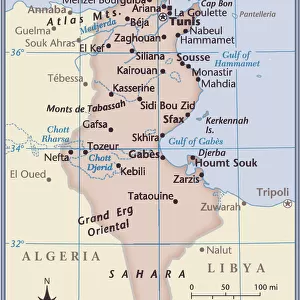
Framed Print : Mareth Line, Tunisia, by G. H. Davis


![]()
Framed Photos from Mary Evans Picture Library
Mareth Line, Tunisia, by G. H. Davis
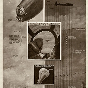
A large-scale contour map of the complicated Mareth Line in Tunisia, North Africa, where General Montgomery stated that the enemys fate would be decided. It was the tactical objective of Allied operations at this stage of the Second World War. Date: 1943
Mary Evans Picture Library makes available wonderful images created for people to enjoy over the centuries
Media ID 14125816
© Illustrated London News Ltd/Mary Evans
1943 Allied Allies Contour Davis Decided Djerba Enemy Fate Germans Gulf Maps Montgomery Operations Scale Strategy Tactical Tunisia Tunisian Gabes Objective
14"x12" (38x32cm) Modern Frame
Introducing the captivating 'Mareth Line, Tunisia' framed print from the Media Storehouse collection. This exquisite piece, sourced from Mary Evans Prints Online, showcases the large-scale contour map of the intricate Mareth Line in Tunisia, North Africa. With historic significance, this map was the focus of intense strategic importance during World War II, where General Montgomery famously declared that the enemy's fate would be decided here. Add this striking framed print to your home or office to showcase the rich history of military strategy and the intricacies of geography. The high-quality print is expertly framed, making it a beautiful and thought-provoking addition to any space.
Wood effect frame, card mounted, 10x8 archival quality photo print. Overall outside dimensions 14x12 inches (38x32cm). Environmentally and ozone friendly, 40mm wide x 15mm Polycore® moulding has the look of real wood, is durable and light and easy to hang. Biodegradable and made with non-chlorinated gases (no toxic fumes) it is efficient; producing 100 tons of polystyrene can save 300 tons of trees! Prints are glazed with lightweight, shatterproof, optical clarity acrylic (providing the same general protection from the environment as glass). The back is stapled hardboard with a sawtooth hanger attached. Note: To minimise original artwork cropping, for optimum layout, and to ensure print is secure, the visible print may be marginally smaller
Contemporary Framed and Mounted Prints - Professionally Made and Ready to Hang
Estimated Image Size (if not cropped) is 17.8cm x 24.4cm (7" x 9.6")
Estimated Product Size is 32.5cm x 37.6cm (12.8" x 14.8")
These are individually made so all sizes are approximate
Artwork printed orientated as per the preview above, with portrait (vertical) orientation to match the source image.
FEATURES IN THESE COLLECTIONS
> Africa
> Related Images
> Africa
> Tunisia
> Related Images
> Europe
> France
> Canton
> Allier
> Europe
> France
> Canton
> Landes
> Europe
> United Kingdom
> Wales
> Powys
> Montgomery
> Historic
> World War I and II
> Generals and leaders
> Maps and Charts
> Early Maps
EDITORS COMMENTS
This large-scale contour map, created by G.H. Davis in 1943, depicts the intricate Mareth Line in Tunisia, North Africa, a strategic position that became the tactical objective of Allied operations during the Second World War. The Mareth Line was a series of fortifications and defensive positions extending from the Gulf of Gabes to the Mediterranean Sea, and was the Germans' final defensive line in Tunisia before their retreat. The line was named after the nearby town of Mareth, and was considered a formidable obstacle due to its natural defenses, including mountains, islands, and the Bou Grara and Grara rivers. At the time this map was made, the outcome of the war in North Africa was uncertain, and the fate of the Axis powers in the region was a topic of intense debate. Allied Commander-in-Chief, General Bernard Montgomery, famously declared that the enemy's fate would be decided at the Mareth Line. The Allied forces launched a series of attacks against the position, culminating in the Battle of Wadi Akarit in March 1943, which ultimately led to the German retreat and the end of the Tunisian campaign. This map provides a detailed view of the complex terrain and strategic features of the Mareth Line, including the Djerba Island, the mountains, and the various fortifications and defensive positions. It is an invaluable historical document, offering insights into the military strategy and tactics employed by both sides during the North African campaign of the Second World War.
MADE IN THE UK
Safe Shipping with 30 Day Money Back Guarantee
FREE PERSONALISATION*
We are proud to offer a range of customisation features including Personalised Captions, Color Filters and Picture Zoom Tools
SECURE PAYMENTS
We happily accept a wide range of payment options so you can pay for the things you need in the way that is most convenient for you
* Options may vary by product and licensing agreement. Zoomed Pictures can be adjusted in the Basket.