Framed Print > Europe > France > Paris > Maps
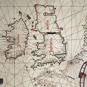
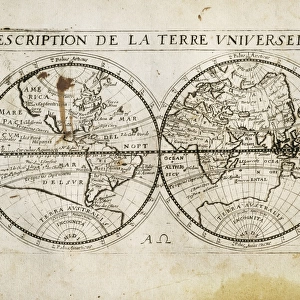
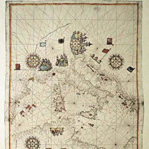
Framed Print : The Caverio Map or Caveri Map, circa 1505. This


![]()
Framed Photos from Mary Evans Picture Library
The Caverio Map or Caveri Map, circa 1505. This
The Caverio Map or Caveri Map, circa 1505. This map was one of the primary sources used to make the Waldseem� map. Miniature Painting. FRANCE. Paris. National Library
Mary Evans Picture Library makes available wonderful images created for people to enjoy over the centuries
Media ID 8282169
© Mary Evans Picture Library 2015 - https://copyrighthub.org/s0/hub1/creation/maryevans/MaryEvansPictureID/10682011
Illuminated Manuscript Manuscripts Miniatures Primary Sources Nicolay
22"x18" (58x48cm) Modern Frame
Introducing the Media Storehouse Framed Prints collection featuring the fascinating "The Caverio Map or Caveri Map, circa 1505." This exquisite piece is a miniature painting sourced from the National Library in Paris, France. One of the primary sources used to create the Waldseemüller map, this rare and historic map showcases intricate details and vibrant colors. Bring a touch of history and artistry to your home or office with our high-quality framed prints. Each print is carefully crafted with attention to detail, ensuring a stunning display that will captivate and inspire. Order yours today and join the ranks of those who appreciate the beauty and significance of historical cartography.
Wood effect frame, card mounted, 16x12 archival quality photo print. Overall outside dimensions 22x18 inches (58x48cm). Environmentally and ozone friendly, 40mm wide x 15mm Polycore® moulding has the look of real wood, is durable and light and easy to hang. Biodegradable and made with non-chlorinated gases (no toxic fumes) it is efficient; producing 100 tons of polystyrene can save 300 tons of trees! Prints are glazed with lightweight, shatterproof, optical clarity acrylic (providing the same general protection from the environment as glass). The back is stapled hardboard with a sawtooth hanger attached. Note: To minimise original artwork cropping, for optimum layout, and to ensure print is secure, the visible print may be marginally smaller
Contemporary Framed and Mounted Prints - Professionally Made and Ready to Hang
Estimated Image Size (if not cropped) is 39.6cm x 21.7cm (15.6" x 8.5")
Estimated Product Size is 57.9cm x 47.8cm (22.8" x 18.8")
These are individually made so all sizes are approximate
Artwork printed orientated as per the preview above, with landscape (horizontal) orientation to match the source image.
FEATURES IN THESE COLLECTIONS
> Europe
> France
> Paris
> Maps
> Europe
> France
> Paris
> Related Images
> Maps and Charts
> Related Images
EDITORS COMMENTS
1. Title: The Caverio Map, Circa 1505: A Glimpse into Early Cartography and Manuscript Illumination The Caverio Map, also known as the Caveri Map, is an exquisite example of early cartography and manuscript illumination, dating back to approximately 1505. This intricately detailed and beautifully colored miniature painting is currently housed in the National Library of France in Paris. As one of the primary sources used to create the renowned Waldseemüller map, the Caverio Map holds significant historical importance. The Waldseemüller map, produced in 1507, is considered the first map to depict the Americas with the names "America" and "New World." The Caverio Map showcases an impressive level of detail, with various geographical features, including rivers, mountains, and coastlines, meticulously rendered. The map is horizontal in orientation, and its vibrant colors and illuminated elements add a striking visual appeal. The map's creation was likely influenced by the extensive travel and exploration of the late 15th and early 16th centuries. The Caverio Map reflects the contemporary understanding of the world at that time, with some inaccuracies and misconceptions that were common during the era. This magnificent manuscript is a testament to the artistic and cartographic achievements of the period. Its intricate details and historical significance make it an essential piece in the study of early cartography and manuscript illumination. The Caverio Map continues to captivate scholars, historians, and enthusiasts alike, offering a fascinating glimpse into the world of exploration and discovery during the Renaissance era.
MADE IN THE UK
Safe Shipping with 30 Day Money Back Guarantee
FREE PERSONALISATION*
We are proud to offer a range of customisation features including Personalised Captions, Color Filters and Picture Zoom Tools
SECURE PAYMENTS
We happily accept a wide range of payment options so you can pay for the things you need in the way that is most convenient for you
* Options may vary by product and licensing agreement. Zoomed Pictures can be adjusted in the Basket.