Fine Art Print > Europe > France > Paris > Maps
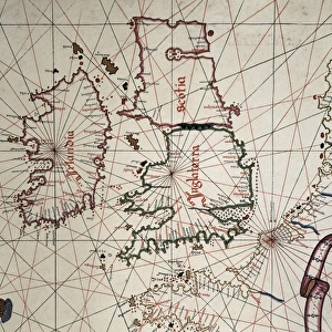
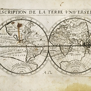
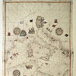
Fine Art Print : The Caverio Map or Caveri Map, circa 1505. This


![]()
Fine Art Prints from Mary Evans Picture Library
The Caverio Map or Caveri Map, circa 1505. This
The Caverio Map or Caveri Map, circa 1505. This map was one of the primary sources used to make the Waldseem� map. Miniature Painting. FRANCE. Paris. National Library
Mary Evans Picture Library makes available wonderful images created for people to enjoy over the centuries
Media ID 8282169
© Mary Evans Picture Library 2015 - https://copyrighthub.org/s0/hub1/creation/maryevans/MaryEvansPictureID/10682011
Illuminated Manuscript Manuscripts Miniatures Primary Sources Nicolay
A2 (42x59cm) Fine Art Print
Discover the captivating detail of the Caverio Map, a rare and intriguing piece from the annals of cartography. Dating back to circa 1505, this exquisite miniature painting is considered one of the primary sources for the creation of the Waldseemüller map. With its vibrant colors and intricate depiction of geographical features, this Fine Art Print from Media Storehouse transports you back in time, offering a glimpse into the world as it was perceived over 500 years ago. Rights Managed through Mary Evans Prints Online, this fine art print is a must-have for history buffs, cartographers, and art enthusiasts alike.
Our Fine Art Prints are printed on 100% acid free, PH neutral paper with archival properties. This printing method is used by museums and art collections to exhibit photographs and art reproductions. Hahnemühle certified studio for digital fine art printing. Printed on 308gsm Photo Rag Paper.
Our fine art prints are high-quality prints made using a paper called Photo Rag. This 100% cotton rag fibre paper is known for its exceptional image sharpness, rich colors, and high level of detail, making it a popular choice for professional photographers and artists. Photo rag paper is our clear recommendation for a fine art paper print. If you can afford to spend more on a higher quality paper, then Photo Rag is our clear recommendation for a fine art paper print.
Estimated Image Size (if not cropped) is 59.4cm x 32.6cm (23.4" x 12.8")
Estimated Product Size is 59.4cm x 42cm (23.4" x 16.5")
These are individually made so all sizes are approximate
Artwork printed orientated as per the preview above, with landscape (horizontal) orientation to match the source image.
FEATURES IN THESE COLLECTIONS
> Europe
> France
> Paris
> Maps
> Europe
> France
> Paris
> Related Images
> Maps and Charts
> Related Images
EDITORS COMMENTS
1. Title: The Caverio Map, Circa 1505: A Glimpse into Early Cartography and Manuscript Illumination The Caverio Map, also known as the Caveri Map, is an exquisite example of early cartography and manuscript illumination, dating back to approximately 1505. This intricately detailed and beautifully colored miniature painting is currently housed in the National Library of France in Paris. As one of the primary sources used to create the renowned Waldseemüller map, the Caverio Map holds significant historical importance. The Waldseemüller map, produced in 1507, is considered the first map to depict the Americas with the names "America" and "New World." The Caverio Map showcases an impressive level of detail, with various geographical features, including rivers, mountains, and coastlines, meticulously rendered. The map is horizontal in orientation, and its vibrant colors and illuminated elements add a striking visual appeal. The map's creation was likely influenced by the extensive travel and exploration of the late 15th and early 16th centuries. The Caverio Map reflects the contemporary understanding of the world at that time, with some inaccuracies and misconceptions that were common during the era. This magnificent manuscript is a testament to the artistic and cartographic achievements of the period. Its intricate details and historical significance make it an essential piece in the study of early cartography and manuscript illumination. The Caverio Map continues to captivate scholars, historians, and enthusiasts alike, offering a fascinating glimpse into the world of exploration and discovery during the Renaissance era.
MADE IN THE UK
Safe Shipping with 30 Day Money Back Guarantee
FREE PERSONALISATION*
We are proud to offer a range of customisation features including Personalised Captions, Color Filters and Picture Zoom Tools
SECURE PAYMENTS
We happily accept a wide range of payment options so you can pay for the things you need in the way that is most convenient for you
* Options may vary by product and licensing agreement. Zoomed Pictures can be adjusted in the Basket.