Framed Print > Arts > Artists > H > Jodocus Hondius
Framed Print : Old County Map of Buckinghamshire 1648 by Johan Blaeu from the Atlas Novus


![]()
Framed Photos from MapSeeker
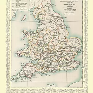
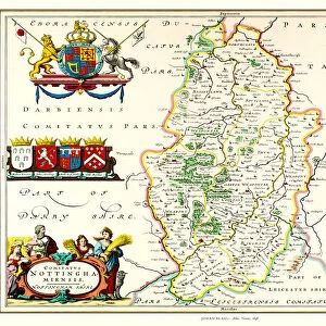
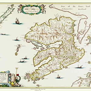
Old County Map of Buckinghamshire 1648 by Johan Blaeu from the Atlas Novus
This detailed and most attractive reproduction map of Buckinghamshire has been carefully art worked from a scan of an antique original. The famous firm of Dutch cartographers and publishers was established in the late 16th century by Willem Janszoon Blaeu in Amsterdam. Blaeu was a maker of globes and scientific instruments and purchased some of his early map plates from Jodocus Hondius. From this small beginning was to emerge one of the largest and most prolific map publishing houses of the seventeenth century
Welcome to the Mapseeker Image library and enter an historic gateway to one of the largest on-line collections of Historic Maps, Nostalgic Views, Vista's and Panorama's from a World gone by.
Media ID 20348164
Blaeu Blaeu Family Blaue Map County Map County Map Of England English County Map Historic Map Johan Blaeu Johan Blaeu Map Old Blaue Map Old County Map Old English County Map Buckinghamshire
22"x18" (58x48cm) Modern Frame
Discover the rich history of Buckinghamshire with our exquisite Framed Print of the Old County Map by Johan Blaeu from the Atlas Novus, available at Media Storehouse. This detailed and captivating reproduction, sourced from MapSeeker, showcases the intricate cartography of Buckinghamshire in 1648 with meticulous artistry. Bring a piece of historical charm into your home or office with this beautifully framed antique map, perfect for history enthusiasts and those who appreciate the beauty of the past.
Wood effect frame, card mounted, 16x12 archival quality photo print. Overall outside dimensions 22x18 inches (58x48cm). Environmentally and ozone friendly, 40mm wide x 15mm Polycore® moulding has the look of real wood, is durable and light and easy to hang. Biodegradable and made with non-chlorinated gases (no toxic fumes) it is efficient; producing 100 tons of polystyrene can save 300 tons of trees! Prints are glazed with lightweight, shatterproof, optical clarity acrylic (providing the same general protection from the environment as glass). The back is stapled hardboard with a sawtooth hanger attached. Note: To minimise original artwork cropping, for optimum layout, and to ensure print is secure, the visible print may be marginally smaller
Contemporary Framed and Mounted Prints - Professionally Made and Ready to Hang
Estimated Image Size (if not cropped) is 26.4cm x 39.6cm (10.4" x 15.6")
Estimated Product Size is 47.8cm x 57.9cm (18.8" x 22.8")
These are individually made so all sizes are approximate
Artwork printed orientated as per the preview above, with portrait (vertical) orientation to match the source image.
FEATURES IN THESE COLLECTIONS
> Arts
> Artists
> B
> Willem Blaeu
> Arts
> Artists
> H
> Jodocus Hondius
> Arts
> Photorealistic artworks
> Detailed art pieces
> Masterful detailing in art
> Europe
> United Kingdom
> England
> Buckinghamshire
> Related Images
> Europe
> United Kingdom
> England
> Maps
> Maps and Charts
> Early Maps
> Maps and Charts
> Related Images
> Maps and Charts
> Willem Janszoon Blaeu
> MapSeeker
> Maps from the British Isles
> England and Counties PORTFOLIO
EDITORS COMMENTS
This beautifully crafted reproduction of the "Old County Map of Buckinghamshire 1648" by Johan Blaeu takes us back in time to explore the historical landscape of this English county. Carefully art worked from a scan of an antique original, this map showcases the intricate details and artistic flair that made Blaeu's maps so renowned. The famous Dutch cartographer and publisher, Willem Janszoon Blaeu, established his firm in Amsterdam during the late 16th century. Initially known for crafting globes and scientific instruments, Blaeu soon expanded his repertoire by acquiring map plates from Jodocus Hondius. This marked the beginning of what would become one of the largest and most prolific map publishing houses of the seventeenth century. As we delve into this old English county map, we are transported to a time when Buckinghamshire was shaped by its rural landscapes, charming villages, and historic landmarks. The attention to detail allows us to trace ancient roads, discover hidden rivers and forests, as well as identify towns that have stood the test of time. Whether you are a history enthusiast or simply appreciate fine cartography, this historic Buckinghamshire map offers a captivating glimpse into England's past. Let your imagination wander through centuries gone by as you explore every corner of this meticulously reproduced piece from Johan Blaeu's Atlas Novus collection.
MADE IN THE UK
Safe Shipping with 30 Day Money Back Guarantee
FREE PERSONALISATION*
We are proud to offer a range of customisation features including Personalised Captions, Color Filters and Picture Zoom Tools
SECURE PAYMENTS
We happily accept a wide range of payment options so you can pay for the things you need in the way that is most convenient for you
* Options may vary by product and licensing agreement. Zoomed Pictures can be adjusted in the Basket.