Framed Print > Europe > United Kingdom > England > Manchester > Salford
Framed Print : Old Map of Manchester and Salford 1898 from the Royal Atlas by Bartholomew


![]()
Framed Photos from MapSeeker
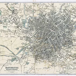
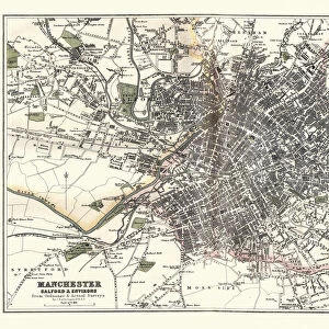
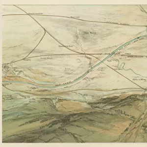
Old Map of Manchester and Salford 1898 from the Royal Atlas by Bartholomew
A fine very detailed plan of the City of Manchester and Salford remastered from an original contained within " The Royal Atlas of England and Wales" ; edited by J.G. Bartholomew, published by George Newnes, Limited, London
Welcome to the Mapseeker Image library and enter an historic gateway to one of the largest on-line collections of Historic Maps, Nostalgic Views, Vista's and Panorama's from a World gone by.
Media ID 20347783
Bartholomew Bartholomew Map Historic Map Old Town Plan Royal Atlas Royal Atlas Map City Of Manchester Manchester Manchester City Salford
22"x18" (58x48cm) Modern Frame
Discover the rich history of Manchester and Salford with our exquisitely detailed Framed Print from Media Storehouse. This Old Map of Manchester and Salford, dated 1898, is an intricately remastered reproduction from the Royal Atlas by Bartholomew. Originally published in "The Royal Atlas of England and Wales" edited by J.G, this vintage map showcases the City of Manchester and Salford in meticulous detail. Bring a piece of historical cartography into your home or office and transport yourself back in time with this beautiful framed print.
Wood effect frame, card mounted, 16x12 archival quality photo print. Overall outside dimensions 22x18 inches (58x48cm). Environmentally and ozone friendly, 40mm wide x 15mm Polycore® moulding has the look of real wood, is durable and light and easy to hang. Biodegradable and made with non-chlorinated gases (no toxic fumes) it is efficient; producing 100 tons of polystyrene can save 300 tons of trees! Prints are glazed with lightweight, shatterproof, optical clarity acrylic (providing the same general protection from the environment as glass). The back is stapled hardboard with a sawtooth hanger attached. Note: To minimise original artwork cropping, for optimum layout, and to ensure print is secure, the visible print may be marginally smaller
Contemporary Framed and Mounted Prints - Professionally Made and Ready to Hang
Estimated Image Size (if not cropped) is 39.6cm x 26.4cm (15.6" x 10.4")
Estimated Product Size is 57.9cm x 47.8cm (22.8" x 18.8")
These are individually made so all sizes are approximate
Artwork printed orientated as per the preview above, with landscape (horizontal) orientation to match the source image.
FEATURES IN THESE COLLECTIONS
> Arts
> Photorealistic artworks
> Detailed art pieces
> Masterful detailing in art
> Europe
> United Kingdom
> England
> London
> Royalty
> Europe
> United Kingdom
> England
> Manchester
> Manchester
> Europe
> United Kingdom
> England
> Manchester
> Salford
> Europe
> United Kingdom
> England
> Maps
> Europe
> United Kingdom
> England
> Salford
> Europe
> United Kingdom
> Wales
> Maps
> Europe
> United Kingdom
> Wales
> Posters
> Maps and Charts
> Related Images
> Maps and Charts
> Wales
> MapSeeker
> British Town And City Plans
> English & Welsh PORTFOLIO
EDITORS COMMENTS
This beautifully preserved print showcases the "Old Map of Manchester and Salford 1898" from the esteemed Royal Atlas by Bartholomew. A true treasure for history enthusiasts, this fine and incredibly detailed plan offers a glimpse into the past, capturing the essence of these bustling cities in their earlier years. Remastered from an original found within "The Royal Atlas of England and Wales" edited by J. G. Bartholomew and published by George Newnes, Limited in London, this map holds immense historical significance. It provides a captivating visual representation of Manchester's urban landscape during a time when it was rapidly evolving. With its intricate cartography and meticulous attention to detail, this old town plan transports us back to an era long gone but not forgotten. The streets are lined with charming buildings that have witnessed countless stories unfold over the years. As we explore this historic map, we can't help but marvel at how much has changed since 1898. From major landmarks to smaller neighborhoods, every corner tells a tale of growth and transformation. Whether you're a proud Mancunian or simply fascinated by history, this royal atlas map is sure to captivate your imagination as you trace the footsteps of those who walked these streets generations ago. It serves as both a testament to our shared heritage and a reminder that even amidst progress, traces of our past continue to shape our present-day cityscape.
MADE IN THE UK
Safe Shipping with 30 Day Money Back Guarantee
FREE PERSONALISATION*
We are proud to offer a range of customisation features including Personalised Captions, Color Filters and Picture Zoom Tools
SECURE PAYMENTS
We happily accept a wide range of payment options so you can pay for the things you need in the way that is most convenient for you
* Options may vary by product and licensing agreement. Zoomed Pictures can be adjusted in the Basket.