Framed Print > Europe > United Kingdom > England > Bristol > Clifton
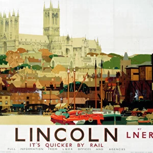
Framed Print : Old Map of Bristol 1851 by John Tallis


![]()
Framed Photos from MapSeeker
Old Map of Bristol 1851 by John Tallis
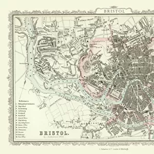
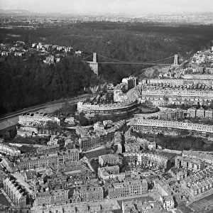
This 1851 John Tallis map of Bristol shows the new course of the River Avon and the Floating Harbour. At Clifton Down the famous suspension bridge is yet to be constructed, but clearly marked as Proposed Suspension Bridge, it was officially opened over a decade later in 1864. The illustrations are of Clifton Down from Rownham Ferry, south side of Bristol Cathedral, Clifton Observatory, High Cross Green, Redcliff Church and a busy scene across Broad Quay Bristol
Welcome to the Mapseeker Image library and enter an historic gateway to one of the largest on-line collections of Historic Maps, Nostalgic Views, Vista's and Panorama's from a World gone by.
Media ID 20347959
Historic Map John Tallis John Tallis Map Old Town Plan Tallis Map Bristol Bristol City
22"x18" (58x48cm) Modern Frame
Step back in time with our Old Map of Bristol 1851 by John Tallis from Media Storehouse. This beautifully framed print showcases an intriguing snapshot of Bristol's history, highlighting the new course of the River Avon and the emerging Floating Harbour. A must-have for history enthusiasts and locals, this map offers a unique perspective on the city's past, with Clifton Down's iconic suspension bridge yet to be constructed. Embrace the charm of the past and add a touch of history to your home decor with our Old Map of Bristol 1851 by John Tallis.
Wood effect frame, card mounted, 16x12 archival quality photo print. Overall outside dimensions 22x18 inches (58x48cm). Environmentally and ozone friendly, 40mm wide x 15mm Polycore® moulding has the look of real wood, is durable and light and easy to hang. Biodegradable and made with non-chlorinated gases (no toxic fumes) it is efficient; producing 100 tons of polystyrene can save 300 tons of trees! Prints are glazed with lightweight, shatterproof, optical clarity acrylic (providing the same general protection from the environment as glass). The back is stapled hardboard with a sawtooth hanger attached. Note: To minimise original artwork cropping, for optimum layout, and to ensure print is secure, the visible print may be marginally smaller
Contemporary Framed and Mounted Prints - Professionally Made and Ready to Hang
Estimated Image Size (if not cropped) is 39.6cm x 26.4cm (15.6" x 10.4")
Estimated Product Size is 57.9cm x 47.8cm (22.8" x 18.8")
These are individually made so all sizes are approximate
Artwork printed orientated as per the preview above, with landscape (horizontal) orientation to match the source image.
FEATURES IN THESE COLLECTIONS
> Architecture
> Bridges
> Clifton Suspension Bridge
> Arts
> Artists
> T
> John Tallis
> Europe
> United Kingdom
> England
> Avon
> Europe
> United Kingdom
> England
> Bristol
> Bristol
> Europe
> United Kingdom
> England
> Bristol
> Clifton
> Europe
> United Kingdom
> Wales
> Ceredigion
> New Quay
> Historic
> Medieval architecture
> Cathedrals and churches
> Church history
> Maps and Charts
> Related Images
> MapSeeker
> British Town And City Plans
> English & Welsh PORTFOLIO
EDITORS COMMENTS
This print showcases the "Old Map of Bristol 1851" by John Tallis, offering a glimpse into the city's rich history. The map depicts Bristol during a transformative period, highlighting significant changes in its landscape and infrastructure. One notable feature is the altered course of the River Avon and the Floating Harbour, reflecting efforts to improve navigation and trade within the city. While exploring this vintage map, one can observe several fascinating illustrations that bring key landmarks to life. Clifton Down captures attention with its absence of the iconic suspension bridge we know today; instead, it is labeled as a proposed project that would later become an emblematic symbol of Bristol's identity when it opened in 1864. Other illustrations include scenic views from Rownham Ferry overlooking Clifton Down, the majestic south side of Bristol Cathedral, Clifton Observatory providing panoramic vistas over the cityscape, High Cross Green bustling with activity, Redcliff Church standing tall against time's passage, and a vibrant scene across Broad Quay showcasing Bristol's thriving commerce. As we delve into this historic treasure trove capturing Bristol's past glory through intricate details and meticulous cartography by John Tallis himself, we are transported back to an era where progress was shaping this remarkable city. This old town plan serves as a testament to both our fascination with history and our appreciation for how far Bristol has come since then.
MADE IN THE UK
Safe Shipping with 30 Day Money Back Guarantee
FREE PERSONALISATION*
We are proud to offer a range of customisation features including Personalised Captions, Color Filters and Picture Zoom Tools
SECURE PAYMENTS
We happily accept a wide range of payment options so you can pay for the things you need in the way that is most convenient for you
* Options may vary by product and licensing agreement. Zoomed Pictures can be adjusted in the Basket.