Home > Europe > United Kingdom > Wales > Maps
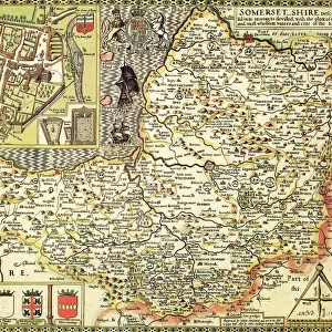
Old Map of Bristol 1866 by Fullarton & Co

![]()
Wall Art and Photo Gifts from MapSeeker
Old Map of Bristol 1866 by Fullarton & Co
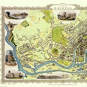
This is an interesting and detailed reproduction Victorian town plan of Bristol which was originally published in John Marius Wilsons The Imperial Gazeteer of England and Wales (A.Fullarton & co. 1865-1874)
Welcome to the Mapseeker Image library and enter an historic gateway to one of the largest on-line collections of Historic Maps, Nostalgic Views, Vista's and Panorama's from a World gone by.
Media ID 20347426
© Mapseeker Publishing Ltd
Historic Map Old Town Plan Bristol Bristol City
FEATURES IN THESE COLLECTIONS
> Arts
> Artists
> W
> Wilson Wilson
> Arts
> Photorealistic artworks
> Detailed art pieces
> Masterful detailing in art
> Europe
> United Kingdom
> England
> Maps
> Europe
> United Kingdom
> Wales
> Maps
> Europe
> United Kingdom
> Wales
> Posters
> Europe
> United Kingdom
> Wales
> Related Images
> Maps and Charts
> Related Images
> Maps and Charts
> Wales
> MapSeeker
> British Town And City Plans
> English & Welsh PORTFOLIO
EDITORS COMMENTS
This print showcases an exquisite reproduction of the "Old Map of Bristol 1866" by Fullarton & Co. Delving into the rich history of Victorian England, this detailed town plan originally appeared in John Marius Wilson's esteemed publication, The Imperial Gazetteer of England and Wales. Transporting us back to a bygone era, this map offers a fascinating glimpse into the bustling cityscape of Bristol during the mid-19th century. Every intricate detail has been meticulously preserved, allowing us to explore the streets and landmarks that once defined this vibrant metropolis. From its charming neighborhoods to its grand architectural marvels, this historic map provides an invaluable resource for historians and enthusiasts alike. Whether you are tracing your family roots or simply captivated by cartographic beauty, this reproduction is sure to ignite your curiosity about Bristol's past. The craftsmanship exhibited in Archibold Fullarton & Co's work is truly remarkable. Their dedication to accuracy and attention to detail shines through every line and contour on this piece. As we study each street name and building outline, we can't help but appreciate their commitment to preserving our collective heritage. With its timeless appeal and historical significance, this Old Map of Bristol serves as both a decorative centerpiece for any space and a gateway into the city's storied past. Let it transport you back in time as you uncover hidden stories within its carefully inked lines - a true testament to the artistry of cartography.
MADE IN THE UK
Safe Shipping with 30 Day Money Back Guarantee
FREE PERSONALISATION*
We are proud to offer a range of customisation features including Personalised Captions, Color Filters and Picture Zoom Tools
SECURE PAYMENTS
We happily accept a wide range of payment options so you can pay for the things you need in the way that is most convenient for you
* Options may vary by product and licensing agreement. Zoomed Pictures can be adjusted in the Basket.