Framed Print > Europe > United Kingdom > England > Norfolk > Beeston
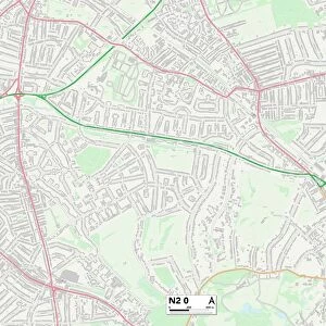
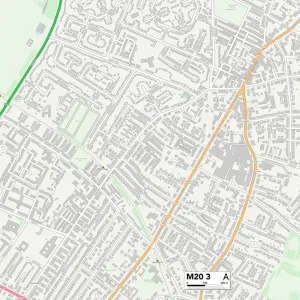
Framed Print : Bury M45 6 Map


![]()
Framed Photos From Map Marketing
Bury M45 6 Map
Postcode Sector Map of Bury M45 6
Media ID 19974274
Alexandra Avenue Argyle Avenue Arundel Avenue Balmoral Avenue Barn Street Barnard Avenue Berwick Avenue Buckingham Avenue Bury Bury New Road Cambridge Grove Carlisle Close Charles Street Chester Avenue Clarence Avenue Clarendon Street Clegg Street Coniston Avenue Connaught Avenue Dalton Avenue Dartmouth Road Derby Road Ducie Street Dudley Avenue Elizabeth Street Furness Avenue Gloucester Avenue Hastings Avenue Hastings Close Heap Street Jackson Street Kenilworth Avenue Kensington Street Kingsley Avenue Lancaster Avenue Ludlow Avenue Mardale Close Mayfair Avenue Morley Street Norfolk Avenue Nursery Road Oak Bank Oxford Avenue Penrith Avenue Peveril Close Raglan Avenue Sandgate Road Thompson Avenue Victoria Avenue Victoria Lane Walker Avenue Warwick Avenue Warwick Close Westminster Avenue Windsor Avenue York Street Whitefield
14"x12" (38x32cm) Modern Frame
Wood effect frame, card mounted, 10x8 archival quality photo print. Overall outside dimensions 14x12 inches (38x32cm). Environmentally and ozone friendly, 40mm wide x 15mm Polycore® moulding has the look of real wood, is durable and light and easy to hang. Biodegradable and made with non-chlorinated gases (no toxic fumes) it is efficient; producing 100 tons of polystyrene can save 300 tons of trees! Prints are glazed with lightweight, shatterproof, optical clarity acrylic (providing the same general protection from the environment as glass). The back is stapled hardboard with a sawtooth hanger attached. Note: To minimise original artwork cropping, for optimum layout, and to ensure print is secure, the visible print may be marginally smaller
Contemporary Framed and Mounted Prints - Professionally Made and Ready to Hang
Estimated Image Size (if not cropped) is 24.4cm x 17.3cm (9.6" x 6.8")
Estimated Product Size is 37.6cm x 32.5cm (14.8" x 12.8")
These are individually made so all sizes are approximate
Artwork printed orientated as per the preview above, with landscape (horizontal) orientation to match the source image.
FEATURES IN THESE COLLECTIONS
> Arts
> Artists
> K
> Charles Kingsley
> Europe
> United Kingdom
> England
> Norfolk
> Beeston
> Europe
> United Kingdom
> England
> Norfolk
> Related Images
> Europe
> United Kingdom
> England
> Norfolk
> Thompson
> Europe
> United Kingdom
> Scotland
> Stirlingshire
> Stirling
> Europe
> United Kingdom
> Wales
> Gwynedd
> Harlech
> Europe
> United Kingdom
> Wales
> Monmouthshire
> Usk
> Europe
> United Kingdom
> Wales
> West Glamorgan
> Neath
> North America
> United States of America
> New York
> New York
> Maps
> Map Marketing
> Postcode Sector Maps
> M - Manchester
MADE IN THE UK
Safe Shipping with 30 Day Money Back Guarantee
FREE PERSONALISATION*
We are proud to offer a range of customisation features including Personalised Captions, Color Filters and Picture Zoom Tools
SECURE PAYMENTS
We happily accept a wide range of payment options so you can pay for the things you need in the way that is most convenient for you
* Options may vary by product and licensing agreement. Zoomed Pictures can be adjusted in the Basket.