Framed Print > Europe > United Kingdom > Northern Ireland > Railways
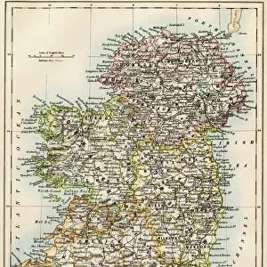
Framed Print : Ireland Political Road Map


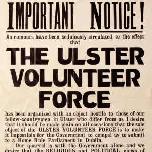
![]()
Framed Photos from Map Marketing
Ireland Political Road Map
A detailed road map of the island of Ireland colour coded by county/district. The detailed map base consists of a comprehensive road network and all main towns as a backdrop with each county shaded in a different colour for ease of identification. In Ulster the county boundaries are marked and named to include the county changes that came into effect in April 2015. Major railway lines, ferry routes and rivers are also shown. City centre street insets are included for Dublin, Belfast and Cork. Information concerning physical features, population, surface area and currency is shown in an inset box
Media ID 19949310
© Map Marketing Ltd 2019, Map derived from Collins Bartholomew Digital Data Collins Bartholomew Ltd 2020
Belfast Cork Counties Dublin Eire Motorways Northern Ireland
14"x12" (38x32cm) Modern Frame
Wood effect frame, card mounted, 10x8 archival quality photo print. Overall outside dimensions 14x12 inches (38x32cm). Environmentally and ozone friendly, 40mm wide x 15mm Polycore® moulding has the look of real wood, is durable and light and easy to hang. Biodegradable and made with non-chlorinated gases (no toxic fumes) it is efficient; producing 100 tons of polystyrene can save 300 tons of trees! Prints are glazed with lightweight, shatterproof, optical clarity acrylic (providing the same general protection from the environment as glass). The back is stapled hardboard with a sawtooth hanger attached. Note: To minimise original artwork cropping, for optimum layout, and to ensure print is secure, the visible print may be marginally smaller
Contemporary Framed and Mounted Prints - Professionally Made and Ready to Hang
Estimated Image Size (if not cropped) is 20.2cm x 24.4cm (8" x 9.6")
Estimated Product Size is 32.5cm x 37.6cm (12.8" x 14.8")
These are individually made so all sizes are approximate
Artwork printed orientated as per the preview above, with portrait (vertical) orientation to match the source image.
FEATURES IN THESE COLLECTIONS
> Arts
> Contemporary art
> Digital artwork
> Street art
> Arts
> Photorealistic artworks
> Detailed art pieces
> Masterful detailing in art
> Europe
> Republic of Ireland
> Cork
> Europe
> Republic of Ireland
> Dublin
> Europe
> Republic of Ireland
> Maps
> Europe
> United Kingdom
> Northern Ireland
> Belfast
> Europe
> United Kingdom
> Northern Ireland
> Maps
> Europe
> United Kingdom
> Northern Ireland
> Politics
> Europe
> United Kingdom
> Northern Ireland
> Posters
> Europe
> United Kingdom
> Northern Ireland
> Railways
MADE IN THE UK
Safe Shipping with 30 Day Money Back Guarantee
FREE PERSONALISATION*
We are proud to offer a range of customisation features including Personalised Captions, Color Filters and Picture Zoom Tools
SECURE PAYMENTS
We happily accept a wide range of payment options so you can pay for the things you need in the way that is most convenient for you
* Options may vary by product and licensing agreement. Zoomed Pictures can be adjusted in the Basket.