Framed Print > Fine Art Storehouse > Photo Libraries > Dorling Kindersley Prints
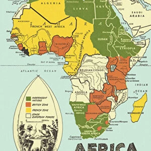
Framed Print : Illustrated map of Africa


![]()
Framed Photos from Fine Art Storehouse
Illustrated map of Africa
Unleash your creativity and transform your space into a visual masterpiece!
Dorling Kindersley
Media ID 13540811
© This content is subject to copyright
African Tribal Culture Background People Geography Human Settlement Illustrated Map Incidental People Indigenous Culture Village African Tribe Watercolour Painting
30"x26" (78x68cm) Modern Frame
Discover the beauty and complexity of Africa with our exquisitely detailed Illustrated Map of Africa by Dorling Kindersley. Part of the Fine Art Storehouse collection from Media Storehouse, this framed print showcases intricately illustrated features, making it an elegant and educational addition to any home or office. The vibrant colors and high-quality printing technique bring the map to life, providing a stunning visual representation of the African continent. Elevate your space with this captivating and conversation-starting piece of art. Order your Illustrated Map of Africa framed print today!
Wood effect frame, card mounted, 24x20 archival quality photo print. Overall outside dimensions 30x26 inches (76x68cm). Environmentally and ozone friendly, 43mm wide x 32mm Polycore® moulding has the look of real wood, is durable and light and easy to hang. Biodegradable and made with non-chlorinated gases (no toxic fumes) it is efficient; producing 100 tons of polystyrene can save 300 tons of trees! Prints are glazed with lightweight, shatterproof, optical clarity acrylic (providing the same general protection from the environment as glass). The back is stapled hardboard with a sawtooth hanger attached. Note: To minimise original artwork cropping, for optimum layout, and to ensure print is secure, the visible print may be marginally smaller
Contemporary Framed and Mounted Prints - Professionally Made and Ready to Hang
Estimated Image Size (if not cropped) is 57.2cm x 59.9cm (22.5" x 23.6")
Estimated Product Size is 68.2cm x 78.2cm (26.9" x 30.8")
These are individually made so all sizes are approximate
Artwork printed orientated as per the preview above, with portrait (vertical) orientation to match the source image.
EDITORS COMMENTS
This print showcases an exquisitely detailed "Illustrated map of Africa" by Dorling Kindersley. Bursting with vibrant colors and intricate designs, this artwork takes us on a visual journey across the vast continent. The artist's skillful use of watercolor painting brings to life the diverse landscapes, human settlements, and indigenous cultures that define Africa. The map is adorned with illustrations depicting various African tribes engaged in their daily activities, creating a rich tapestry of traditions and customs. In the background, we catch glimpses of bustling villages and serene natural wonders that dot the landscape. This fusion of geography and human settlement offers a comprehensive understanding of Africa's physical features alongside its vibrant cultural heritage. Against a clean white background, every detail stands out vividly - from the flowing rivers to towering mountains - allowing viewers to immerse themselves in this artistic interpretation of Africa's beauty. The inclusion of incidental people adds depth and realism to the composition while emphasizing the importance of community within African tribal culture. Whether displayed in homes or educational institutions, this vertical masterpiece serves as both an informative tool for geographical exploration and a celebration of Africa's rich diversity. With its impeccable craftsmanship and attention to detail, Dorling Kindersley has created an illustrated map that invites viewers into an enchanting world where art seamlessly intertwines with knowledge about one remarkable continent – Africa.
MADE IN THE UK
Safe Shipping with 30 Day Money Back Guarantee
FREE PERSONALISATION*
We are proud to offer a range of customisation features including Personalised Captions, Color Filters and Picture Zoom Tools
SECURE PAYMENTS
We happily accept a wide range of payment options so you can pay for the things you need in the way that is most convenient for you
* Options may vary by product and licensing agreement. Zoomed Pictures can be adjusted in the Basket.