Framed Print > North America > United States of America > New York > New York > Maps
Framed Print : Canada British America map of 1869


![]()
Framed Photos From Fine Art Storehouse
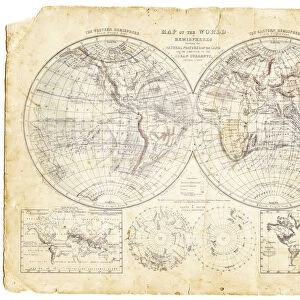
Canada British America map of 1869
Cornells Grammar School Geography By S.S. Cornell - New York 1869
Unleash your creativity and transform your space into a visual masterpiece!
THEPALMER
Media ID 18106821
© 2014 Roberto Adrian Photography
14"x12" (38x32cm) Modern Frame
Step back in time with our exquisite Framed Print of the "Canada British America Map of 1869" from ThePalmer collection at Media Storehouse. This fascinating piece of cartographic history comes from the Cornell's Grammar School Geography book published in New York in 1869. Each detail of this vintage map is meticulously captured in high resolution, allowing you to explore the intricacies of Canada and British America during this era. The museum-quality print is beautifully framed, adding a touch of historical charm to any room in your home or office. Bring a piece of the past into your present with this captivating Framed Print from Media Storehouse's Fine Art collection.
Wood effect frame, card mounted, 10x8 archival quality photo print. Overall outside dimensions 14x12 inches (38x32cm). Environmentally and ozone friendly, 40mm wide x 15mm Polycore® moulding has the look of real wood, is durable and light and easy to hang. Biodegradable and made with non-chlorinated gases (no toxic fumes) it is efficient; producing 100 tons of polystyrene can save 300 tons of trees! Prints are glazed with lightweight, shatterproof, optical clarity acrylic (providing the same general protection from the environment as glass). The back is stapled hardboard with a sawtooth hanger attached. Note: To minimise original artwork cropping, for optimum layout, and to ensure print is secure, the visible print may be marginally smaller
Contemporary Framed and Mounted Prints - Professionally Made and Ready to Hang
Estimated Image Size (if not cropped) is 24.4cm x 19.4cm (9.6" x 7.6")
Estimated Product Size is 37.6cm x 32.5cm (14.8" x 12.8")
These are individually made so all sizes are approximate
Artwork printed orientated as per the preview above, with landscape (horizontal) orientation to match the source image.
FEATURES IN THESE COLLECTIONS
> Fine Art Storehouse
> Map
> Historical Maps
> Maps and Charts
> Related Images
> North America
> Canada
> Maps
> North America
> Canada
> Related Images
> North America
> United States of America
> New York
> New York
> Maps
> North America
> United States of America
> New York
> Related Images
EDITORS COMMENTS
This print showcases a historical gem, the Canada British America map of 1869. A true testament to the rich tapestry of our past, this piece is taken from "Cornells Grammar School Geography" by S. S. Cornell - New York 1869. The intricate details and exquisite craftsmanship transport us back to an era when cartography was both an art form and a scientific endeavor. The map itself is a visual feast for the eyes, meticulously depicting the vast expanse of Canada's territories during that time. Every contour and boundary line tells a story of exploration, colonization, and cultural exchange. It serves as a window into an age where geographical knowledge was expanding rapidly. The choice to present this particular photograph in black and white adds depth and nostalgia to its overall aesthetic appeal. The monochromatic tones lend themselves perfectly to capturing the essence of history frozen in time. "ThePALMER" through their lens, has masterfully captured not only the physicality but also the spirit encapsulated within this vintage map print. This artwork invites us on a journey through time while simultaneously reminding us of how far we have come as nations united under one flag. Whether you are an avid historian or simply appreciate fine art with historical significance, this print promises to be an intriguing addition to any collection or space it graces – offering endless opportunities for reflection upon our shared heritage.
MADE IN THE UK
Safe Shipping with 30 Day Money Back Guarantee
FREE PERSONALISATION*
We are proud to offer a range of customisation features including Personalised Captions, Color Filters and Picture Zoom Tools
SECURE PAYMENTS
We happily accept a wide range of payment options so you can pay for the things you need in the way that is most convenient for you
* Options may vary by product and licensing agreement. Zoomed Pictures can be adjusted in the Basket.