Framed Print > Arts > Landscape paintings > Waterfall and river artworks > River artworks
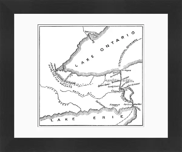
Framed Print : Antique Map of Niagara River Area during the War of 1812 - 19th Century


![]()
Framed Photos from Fine Art Storehouse
Antique Map of Niagara River Area during the War of 1812 - 19th Century
Vintage map showing early territorial borders and military positions in the Niagara River area during the War of 1812. Vintage etching circa late 19th century
Unleash your creativity and transform your space into a visual masterpiece!
powerofforever
Media ID 15149729
© This content is subject to copyright
30"x26" (78x68cm) Modern Frame
Step back in time with this stunning antique map of the Niagara River Area during the War of 1812, part of the Media Storehouse Framed Prints collection from Fine Art Storehouse. This vintage etching, circa late 19th century, offers a captivating glimpse into the early territorial borders and military positions in the Niagara River area during this pivotal historical period. With intricate detail and authentic aged patina, this framed print is not only a beautiful addition to your home or office decor, but also a fascinating conversation starter and educational piece. Bring history to life with the Media Storehouse Framed Prints collection.
Wood effect frame, card mounted, 24x20 archival quality photo print. Overall outside dimensions 30x26 inches (76x68cm). Environmentally and ozone friendly, 43mm wide x 32mm Polycore® moulding has the look of real wood, is durable and light and easy to hang. Biodegradable and made with non-chlorinated gases (no toxic fumes) it is efficient; producing 100 tons of polystyrene can save 300 tons of trees! Prints are glazed with lightweight, shatterproof, optical clarity acrylic (providing the same general protection from the environment as glass). The back is stapled hardboard with a sawtooth hanger attached. Note: To minimise original artwork cropping, for optimum layout, and to ensure print is secure, the visible print may be marginally smaller
Contemporary Framed and Mounted Prints - Professionally Made and Ready to Hang
Estimated Image Size (if not cropped) is 59.9cm x 59.6cm (23.6" x 23.5")
Estimated Product Size is 78.2cm x 68.2cm (30.8" x 26.9")
These are individually made so all sizes are approximate
Artwork printed orientated as per the preview above, with landscape (horizontal) orientation to match the source image.
FEATURES IN THESE COLLECTIONS
> Fine Art Storehouse
> Map
> Historical Maps
> Arts
> Landscape paintings
> Waterfall and river artworks
> River artworks
> Maps and Charts
> Early Maps
> Maps and Charts
> Related Images
EDITORS COMMENTS
This antique map takes us back in time to the tumultuous era of the War of 1812. A true treasure for history enthusiasts, this vintage etching from the late 19th century offers a glimpse into the early territorial borders and military positions along the Niagara River area during this significant conflict. With intricate details and expert craftsmanship, this print showcases not only geographical features but also strategic fortifications such as Fort Schlosser that played a crucial role during those turbulent times. The map's faded hues and delicate lines evoke a sense of nostalgia, transporting us to an era long gone. As we study this remarkable piece, we can't help but imagine the soldiers who once stood on these very grounds, defending their territories with unwavering determination. It serves as a poignant reminder of the sacrifices made by countless individuals during one of America's defining moments. Whether you're an avid historian or simply appreciate artistry from bygone eras, this Antique Map of Niagara River Area during the War of 1812 is sure to captivate your imagination and spark conversations about our shared past. Display it proudly in your home or office as a testament to our collective heritage and an enduring symbol of resilience amidst adversity.
MADE IN THE UK
Safe Shipping with 30 Day Money Back Guarantee
FREE PERSONALISATION*
We are proud to offer a range of customisation features including Personalised Captions, Color Filters and Picture Zoom Tools
SECURE PAYMENTS
We happily accept a wide range of payment options so you can pay for the things you need in the way that is most convenient for you
* Options may vary by product and licensing agreement. Zoomed Pictures can be adjusted in the Basket.