Framed Print > Maps and Charts > Related Images
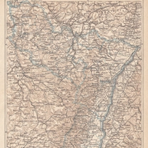
Framed Print : Alsace-Lorraine map 1880


![]()
Framed Photos from Fine Art Storehouse
Alsace-Lorraine map 1880
Illustration of a Alsace-Lorraine map 1880
Unleash your creativity and transform your space into a visual masterpiece!
Nastasic
Media ID 14756708
© This content is subject to copyright
Franco Prussian War Alsace Lorraine
14"x12" (38x32cm) Modern Frame
Step back in time with our exquisite Framed Print of the Alsace-Lorraine Map 1880 by Nastasic from the Fine Art Storehouse. This beautifully detailed map, hailing from the late 19th century, showcases the historical borders of Alsace-Lorraine during an era of significant European history. The intricate lines and borders are brought to life with vibrant colors, making this a must-have for history enthusiasts and art collectors alike. Framed in a sleek, contemporary design, this print not only adds a touch of historical charm to any room but also makes for a stunning conversation starter. Bring a piece of the past into your present with the Alsace-Lorraine Map 1880 Framed Print from the Media Storehouse Fine Art Collection.
Wood effect frame, card mounted, 10x8 archival quality photo print. Overall outside dimensions 14x12 inches (38x32cm). Environmentally and ozone friendly, 40mm wide x 15mm Polycore® moulding has the look of real wood, is durable and light and easy to hang. Biodegradable and made with non-chlorinated gases (no toxic fumes) it is efficient; producing 100 tons of polystyrene can save 300 tons of trees! Prints are glazed with lightweight, shatterproof, optical clarity acrylic (providing the same general protection from the environment as glass). The back is stapled hardboard with a sawtooth hanger attached. Note: To minimise original artwork cropping, for optimum layout, and to ensure print is secure, the visible print may be marginally smaller
Contemporary Framed and Mounted Prints - Professionally Made and Ready to Hang
Estimated Image Size (if not cropped) is 19.2cm x 24.4cm (7.6" x 9.6")
Estimated Product Size is 32.5cm x 37.6cm (12.8" x 14.8")
These are individually made so all sizes are approximate
Artwork printed orientated as per the preview above, with portrait (vertical) orientation to match the source image.
FEATURES IN THESE COLLECTIONS
> Fine Art Storehouse
> Map
> Historical Maps
> Maps and Charts
> Related Images
EDITORS COMMENTS
This print showcases a historical gem, the Alsace-Lorraine map from 1880. With intricate details and vibrant colors, this illustration takes us back to a significant era in European history. The Alsace-Lorraine region, nestled between France and Germany, witnessed intense conflicts during the Franco-Prussian War of 1870-1871. As we gaze upon this artwork by Nastasic, we are transported to a time when borders were fiercely contested and power struggles shaped nations. This map serves as a visual testament to the complex history of Alsace-Lorraine, reflecting its cultural diversity and strategic importance. The delicate lines trace the contours of towns and rivers while highlighting key landmarks that defined this disputed territory. From Strasbourg's majestic cathedral to Metz's formidable fortifications, each detail tells a story of resilience amidst turmoil. Beyond its historical significance, this print also captivates with its aesthetic appeal. The artist's skillful rendering brings life to every corner of the map – whether it be lush forests or charming villages dotting the landscape. Whether you are an avid historian or simply appreciate fine art, this print is sure to spark curiosity and ignite conversations about geopolitics and identity. It stands as both an educational tool for understanding past conflicts and an exquisite piece that adds character to any space it graces.
MADE IN THE UK
Safe Shipping with 30 Day Money Back Guarantee
FREE PERSONALISATION*
We are proud to offer a range of customisation features including Personalised Captions, Color Filters and Picture Zoom Tools
SECURE PAYMENTS
We happily accept a wide range of payment options so you can pay for the things you need in the way that is most convenient for you
* Options may vary by product and licensing agreement. Zoomed Pictures can be adjusted in the Basket.