Fine Art Print > Maps and Charts > Related Images
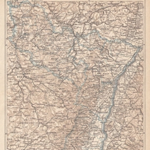
Fine Art Print : Alsace-Lorraine map 1880


![]()
Fine Art Prints from Fine Art Storehouse
Alsace-Lorraine map 1880
Illustration of a Alsace-Lorraine map 1880
Unleash your creativity and transform your space into a visual masterpiece!
Nastasic
Media ID 14756708
© This content is subject to copyright
Franco Prussian War Alsace Lorraine
A2 (42x59cm) Fine Art Print
Discover the rich history and cultural heritage of Alsace-Lorraine with our exquisite Fine Art Print of the 1880 map by Nastasic, available at Media Storehouse. This detailed and intricately designed map transports you back in time, capturing the political boundaries and geographical features of the region during a pivotal period in European history. The vibrant colors and high-quality printing bring the map to life, making it a stunning addition to any home or office. Relive the stories of the past and add a touch of history to your space with our Fine Art Print of Alsace-Lorraine 1880 by Nastasic.
Our Fine Art Prints are printed on 100% acid free, PH neutral paper with archival properties. This printing method is used by museums and art collections to exhibit photographs and art reproductions. Hahnemühle certified studio for digital fine art printing. Printed on 308gsm Photo Rag Paper.
Our fine art prints are high-quality prints made using a paper called Photo Rag. This 100% cotton rag fibre paper is known for its exceptional image sharpness, rich colors, and high level of detail, making it a popular choice for professional photographers and artists. Photo rag paper is our clear recommendation for a fine art paper print. If you can afford to spend more on a higher quality paper, then Photo Rag is our clear recommendation for a fine art paper print.
Estimated Image Size (if not cropped) is 42cm x 53.5cm (16.5" x 21.1")
Estimated Product Size is 42cm x 59.4cm (16.5" x 23.4")
These are individually made so all sizes are approximate
Artwork printed orientated as per the preview above, with portrait (vertical) orientation to match the source image.
FEATURES IN THESE COLLECTIONS
> Maps and Charts
> Related Images
> Fine Art Storehouse
> Map
> Historical Maps
EDITORS COMMENTS
This print showcases a historical gem, the Alsace-Lorraine map from 1880. With intricate details and vibrant colors, this illustration takes us back to a significant era in European history. The Alsace-Lorraine region, nestled between France and Germany, witnessed intense conflicts during the Franco-Prussian War of 1870-1871. As we gaze upon this artwork by Nastasic, we are transported to a time when borders were fiercely contested and power struggles shaped nations. This map serves as a visual testament to the complex history of Alsace-Lorraine, reflecting its cultural diversity and strategic importance. The delicate lines trace the contours of towns and rivers while highlighting key landmarks that defined this disputed territory. From Strasbourg's majestic cathedral to Metz's formidable fortifications, each detail tells a story of resilience amidst turmoil. Beyond its historical significance, this print also captivates with its aesthetic appeal. The artist's skillful rendering brings life to every corner of the map – whether it be lush forests or charming villages dotting the landscape. Whether you are an avid historian or simply appreciate fine art, this print is sure to spark curiosity and ignite conversations about geopolitics and identity. It stands as both an educational tool for understanding past conflicts and an exquisite piece that adds character to any space it graces.
MADE IN THE UK
Safe Shipping with 30 Day Money Back Guarantee
FREE PERSONALISATION*
We are proud to offer a range of customisation features including Personalised Captions, Color Filters and Picture Zoom Tools
SECURE PAYMENTS
We happily accept a wide range of payment options so you can pay for the things you need in the way that is most convenient for you
* Options may vary by product and licensing agreement. Zoomed Pictures can be adjusted in the Basket.