Framed Print > Europe > France > Paris > Maps
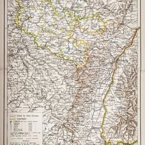
Framed Print : France Alsace-Lorraine map 1887


![]()
Framed Photos From Fine Art Storehouse
France Alsace-Lorraine map 1887
Map from La Premiere Annee de Geographie par P. Foncin - Paris 1887
Unleash your creativity and transform your space into a visual masterpiece!
THEPALMER
Media ID 20773137
© A 2014 Roberto Adrian Photography
14"x12" (38x32cm) Modern Frame
Step back in time with our exquisite Framed Print of "France Alsace-Lorraine Map 1887" from THEPALMER's Fine Art Storehouse collection. This beautifully preserved antique map, originally published in P. Foncin's "La Premiere Annee de Geographie" in Paris, 1887, offers a captivating glimpse into the historical cartography of France during the late 19th century. The intricate details and rich colors of the map are showcased in our high-quality frame, making it an excellent addition to any home or office for those who appreciate history and the art of cartography.
Wood effect frame, card mounted, 10x8 archival quality photo print. Overall outside dimensions 14x12 inches (38x32cm). Environmentally and ozone friendly, 40mm wide x 15mm Polycore® moulding has the look of real wood, is durable and light and easy to hang. Biodegradable and made with non-chlorinated gases (no toxic fumes) it is efficient; producing 100 tons of polystyrene can save 300 tons of trees! Prints are glazed with lightweight, shatterproof, optical clarity acrylic (providing the same general protection from the environment as glass). The back is stapled hardboard with a sawtooth hanger attached. Note: To minimise original artwork cropping, for optimum layout, and to ensure print is secure, the visible print may be marginally smaller
Contemporary Framed and Mounted Prints - Professionally Made and Ready to Hang
Estimated Image Size (if not cropped) is 19.8cm x 24.4cm (7.8" x 9.6")
Estimated Product Size is 32.5cm x 37.6cm (12.8" x 14.8")
These are individually made so all sizes are approximate
Artwork printed orientated as per the preview above, with portrait (vertical) orientation to match the source image.
FEATURES IN THESE COLLECTIONS
> Europe
> France
> Paris
> Maps
> Maps and Charts
> Related Images
EDITORS COMMENTS
This print showcases a historical gem - the France Alsace-Lorraine map from 1887. Taken from the renowned publication "La Premiere Annee de Geographie" by P. Foncin, this exquisite piece of cartography takes us back to a time when borders were shifting and Europe was undergoing significant changes. The map itself is a testament to the intricate artistry and attention to detail that went into creating such masterpieces in the late 19th century. With its delicate lines, vibrant colors, and meticulously labeled towns and regions, it offers an immersive glimpse into the geographical landscape of France's Alsace-Lorraine region during that era. As we gaze upon this remarkable print by THEPALMER, we are transported to a time when political boundaries were fluid, reflecting the complex history of this region. It serves as a reminder of how geography can be intertwined with cultural identity and national aspirations. Whether you are an avid historian or simply appreciate fine art, this print is sure to captivate your imagination. Its timeless appeal lies not only in its historical significance but also in its ability to evoke curiosity about our past and spark conversations about geopolitical transformations. Displaying this stunning artwork on your wall will undoubtedly become a conversation starter for guests who will marvel at both its aesthetic beauty and rich historical context. So why not bring home a piece of history with this extraordinary France Alsace-Lorraine map from 1887?
MADE IN THE UK
Safe Shipping with 30 Day Money Back Guarantee
FREE PERSONALISATION*
We are proud to offer a range of customisation features including Personalised Captions, Color Filters and Picture Zoom Tools
SECURE PAYMENTS
We happily accept a wide range of payment options so you can pay for the things you need in the way that is most convenient for you
* Options may vary by product and licensing agreement. Zoomed Pictures can be adjusted in the Basket.